
China News Service, November 12, according to the website of the Central Meteorological Observatory, starting on the morning of the 12th, affected by the weak cold air, the haze weather in North China, the central and western parts of Huanghuai and the Fenwei Plain will gradually weaken or dissipate from north to south.
Affected by the typhoon's "ring high" and cold air, from 08:00 on the 12th to 08:00 on the 13th, there will be 7-8 strong winds in the Bashi Strait, northern and central parts of the South China Sea, among which the eastern part of the South China Sea and the waters near Huangyan Island , There will be 9-10 strong winds in the waters near the Zhongsha Islands.
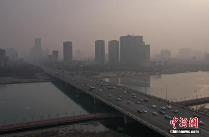
Data map: The city's tall buildings are looming in the smog.
Photo by China News Agency reporter Wu Junjie
Haze or fog appears in Beijing, Tianjin, Hebei and other places this morning
This morning, haze or fog appeared in Beijing, western Tianjin, southern Hebei, central and southern Shanxi, central and southern Shandong, most of Henan, and Guanzhong. Local areas such as Beijing and central Hebei were heavily haze.
Yesterday, most of the country's precipitation was weak, and there was moderate rain in the eastern part of Hainan Island.
Haze weather in Huanghuai and other places in North China will gradually weaken or dissipate
Starting from the morning of the 12th, affected by the weak cold air, the haze weather in North China, the central and western Huanghuai, and the Fenwei Plain will gradually weaken or dissipate from north to south. However, before the arrival of the cold air, there will still be light to moderate haze in these areas. There is severe haze on the ground.
Starting from the 14th, the atmospheric diffusion conditions in the Beijing-Tianjin-Hebei region will deteriorate again.
In addition, from the 12th to the 13th, there will be 4 to 6 winds in the central and eastern parts of Inner Mongolia and the northeastern region, and the temperature will drop by 4 to 8°C, and the local temperature will be above 8°C.
There will be heavy wind and rain in the central and northern areas of the South China Sea
The center of this year's No. 22 typhoon "Huan Gao" made landfall on the eastern coast of Luzon Island in the Philippines early this morning (12th). The maximum wind force near the center was 14 (42 m/s) when it landed.
At 5 o'clock this morning, the center of "Huan Gao" is located in the central and western part of Luzon Island in the Philippines, which is 15.4 degrees north latitude and 120.3 degrees east longitude. The maximum wind force near the center is 13 levels (38 m/s), and the lowest pressure at the center is 965 hPa.
It is expected that the "Huan Gao" will move westward at a speed of 20-25 kilometers per hour, and will soon move into the middle of the South China Sea around noon on the 12th, with little change in intensity. After passing through the Zhongsha Islands and the Paracel Islands, it continues to move towards The northern coast of Vietnam is close.
Affected by the "ring high" and cold air, from 08:00 on the 12th to 08:00 on the 13th, the Bashi Strait, Taiwan Strait, east of Taiwan, northern and central South China Sea, waters near Huangyan Island, Zhongsha Islands, Paracel Islands, and the north There will be strong winds of magnitude 7-8 in the southern part of the bay, of which the middle east of the South China Sea and the waters near Huangyan Island, and the waters near the Zhongsha Islands will have strong winds of 9-10, and the surrounding seas passing by the center of "Huan Gao" will have winds of 11-13. , Gust 14.
There will be heavy rain to heavy rain (100-160 mm) in the waters near Huangyan Island.
To this end, the Central Meteorological Observatory continued to issue a blue typhoon warning at 06:00 on November 12.
Specific forecast for the next three days
From 08:00 on November 12 to 08:00 on the 13th, there was light snow or sleet in parts of northeastern Inner Mongolia, northern Heilongjiang, northern Xinjiang, and Ili River Valley. Among them, northwest Heilongjiang and northern Xinjiang There is moderate to heavy snow in the area.
There was light to moderate rain in parts of the eastern part of Northeast China, western Sichuan Basin and Taiwan Island.
There are 4 to 6 winds in parts of Northeast Inner Mongolia, the east of Northeast China and the north of North China (see Figure 1).
Figure 1 National precipitation forecast map (08:13-13:08, November 12)
From 08:00 on November 13th to 08:00 on the 14th, there was light to moderate snow or sleet in parts of northern Xinjiang, the Ili River Valley and the western mountainous areas of southern Xinjiang.
There were light to moderate rains in western Sichuan Basin, southeastern Fujian, eastern Hainan Island, and Taiwan Island. Among them, there were heavy rains or heavy rains (50-80 mm) in parts of eastern Taiwan Island.
There are 4 to 5 winds in parts of the eastern part of Northwest China (see Figure 2).
Figure 2 National precipitation forecast map (from 08:00 on November 13 to 8:00 on November 14)
From 08:00 on November 14 to 08:00 on the 15th, there were light snow or sleet in parts of northern Xinjiang, Ili River Valley, and western mountainous areas of southern Xinjiang, and heavy snow or heavy snow in the western mountainous areas of southern Xinjiang.
There were moderate to heavy rains in the southwest coast of Guangdong and Hainan Island. Among them, there were heavy rains or heavy rains (100-150 mm) in parts of the southern Leizhou Peninsula and the central and eastern parts of Hainan Island.
There are 4 to 6 winds in the southern Xinjiang Basin and parts of the east of Xinjiang (see Figure 3).
Figure 3 National precipitation forecast map (08:15-15:08, November 14)