
- Bad weather returns to the center-north, weather alert for storm winds
- Bad weather. Strong wind in half of Italy, in Milan a tree falls in Corso Sempione, damaged cars
- Bad weather. All Italy invested
Share
February 28, 2020 Rain, wind and snow will accompany us for most of next week. We will have to wait Thursday afternoon for an improvement in weather conditions.Colle Maddalena closed to heavy vehicles
Due to adverse weather conditions - snow - and following the same provision issued by the French network operator, on state road 21 "of the Colle della Maddalena", connection between Cuneo and Barcelonnette, Anas blocked vehicles above 19 tons in the stretch between Argentera and the state border. Anas snow plows are at work.
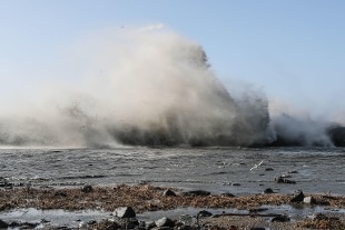
Road section 36 due to snow storm in Sondrio closed
The stretch along the highway 36 of Lake Como and the Spluga is temporarily closed from km 140,800 to km 147,000, in Madesimo (Sondrio), due to a snowstorm. Anas points out that by specifying that, on the spot, Anas teams are present to manage the emergency and to restore normal circulation in the shortest possible time.
Due to the strong wind stop Laziomar ships with Pontine islands
Due to adverse weather conditions, due to the strong wind, there are inconveniences in the Laziomar connections with the Pontine Islands. In particular, the Formia-Ponza races at 2.30 pm and Formia-Ventotene at 3.30 pm today will not be carried out. Furthermore, for the same reason, the Ponza-Formia race at 8.00 am had not been carried out, while the Ventotene - Formia race at 06.45 am postponed the departure at 08.45. This was announced by Astral Infomobilità.
Strong winds in Veneto
Today strong northern winds over the mountainous areas of Veneto, while gusts of Foehn may be recorded in the valleys and in the foothills. This was reported by the Regional Civil Protection, which decreed the state of attention for strong winds to be reconfigured at the local level during the pre-alarm or alarm operational phase, from midnight today until 2 pm tomorrow, Friday 28 February.
From Sunday still days in the sign of instability
From Sunday still days in the sign of instability. In the North, heavily cloudy or overcast skies over most of the sector with weak scattered precipitations, more widespread and intense on Friuli Venezia-Giulia, where they will also take on a reversed nature; snow on the relative alpine and pre-Alpine areas above 800-1,000 meters. From the late morning, gradual improvement with absorption of rainfall starting from the western regions, pending a new worsening which will affect the westernmost alpine areas in the early hours of the night. After sunset, thick mist forms on the central-eastern Po Valley.
Central and Sardinia: many compact clouds over the Tyrrhenian regions, Umbria and the Apennine mountains of Marche and Abruzzo with scattered rains or showers, locally also storms close to the Apennine ridge; from the evening expected an attenuation of the phenomena on Sardinia and Tuscany. Thick glazes on the remaining areas of the Adriatic regions.
South and Sicily: substantial coverage over western Molise, Campania and Tyrrhenian Basilicata with weak associated phenomena expected from late morning; dry albeit with extensive medium-high cloudiness and stratified on the rest of the South, except for a few more compact clouds that will affect the Salento Puglia in the morning.
Monday 2 March : cloud cover spreading to the north and the central Tyrrhenian regions with extensive phenomena, also reversed or temporal, more intense over eastern Liguria and the Apuan Alps; moderate snowfall on alpine and pre-Alpine areas above 600-800 meters. Compact glazes on the rest of the country, with a tendency to worsen from the evening.
Tuesday 3 March : initial bad weather everywhere with widespread rains and showers, locally intense on the Tyrrhenian and Triveneto areas, but gradually improving in the morning first on the North-West and then, between afternoon and evening, also on Lombardy, Emilia and a large part the Center, especially the Tyrrhenian sector; intense and abundant snowfalls on the central eastern Alps, in nocturnal attenuation.
Wednesday 4 March: residual early morning rainfall on the north Adriatic coast, but following a rapid improvement; still many clouds in the south and on the central Adriatic regions with phenomena also of a reversed nature which have diminished since the evening; cloudy or veiled sky elsewhere, with more compact clouds in the evening over the western Alpine chain and Sardinia, where new rainfall is expected.
On Thursday 5 March still unstable conditions over most of the central and southern regions and the Alpine border areas, but improving in the afternoon on the central peninsular sector, while ever wider openings will affect the rest of the north.