
Rafah was divided into two parts after the Camp David Accords, a Palestinian part and an Egyptian part (activists)
An ancient Palestinian city, dating back five thousand years, located in the far south of the Gaza Strip, on the border with the Arab Republic of Egypt. It represents the Gaza Strip's gateway to the world, and is considered a sensitive strategic axis because it is located on the hot confrontation line in the region with Israel.
After the war launched by Israel in October 2023 on Gaza, Rafah became a forced home for displaced Palestinians from all over the Strip, whose number reached more than a million, living in harsh humanitarian conditions, and under Israeli pressure aimed at displacing them to the Sinai Peninsula.
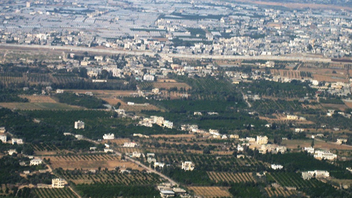
Location and geography
The city of Rafah is located in the far south of the Gaza Strip, on the border with the Sinai Peninsula. It is bordered to the north by Khan Yunis, to the south by Egyptian territory, to the west by the Mediterranean Sea, and to the east by the Green Line, which separates the Palestinian territories in 1967 from the territories occupied in 1948.
The city is located near the Mediterranean Sea, and is 48 meters above its surface. It includes the range of the Palestinian coastal plain, at its meeting line with the Sinai Desert on the one hand, and the Negev Desert on the other hand. Therefore, a semi-desert environment is formed in the region, whose soil consists of sandy barren land, spread It has dunes.
The city is considered the center of Rafah Governorate, which includes 10 neighborhoods and residential communities: Al-Mawasi area, Tal Al-Sultan, Downtown, Al-Hashash, Western Rafah, Al-Nakhla neighborhood, Khirbet Al-Adas, Al-Salam neighborhood, Al-Jeneina, and Al-Byouk. Its area is estimated at 63 square kilometers, according to the Palestinian Central Bureau of Statistics for the year 2017.
the climate
Rafah enjoys a semi-desert climate due to its proximity to the desert region of Sinai and the Negev. Summers are long, hot and humid, and winters are cold and dry. The annual temperature usually ranges between 9 degrees Celsius in winter and 31 degrees Celsius in summer, and is rarely less than 6 degrees Celsius or higher than 33 degrees Celsius. It rains mostly in the winter, with an annual rainfall rate of about 250 mm.
Importance
Rafah occupies an important strategic location for Palestine and the Gaza Strip. It is the southern gate closest to Egypt, and the twin city of Rafah in Egypt, which is less than two kilometers away from it. It represents the same importance to Egypt, as before the Israeli occupation it was an important link between Egypt, Palestine, and the Arab Levant in general. The railway line between Cairo and Haifa passed through its territory, which was destroyed after 1967.
Following the Israeli occupation of Palestine, the region became a sensitive axis in the conflict with Israel, as the city is barely more than 7.6 kilometers away from the armistice line drawn up in accordance with the 1949 agreement, and is located near the Philadelphia axis, the line that most provokes political skirmishes and the escalation of military activity. It is also characterized by Due to its proximity to the Gaza envelope settlements, it is 12 kilometers from the “Nir Ishaq” settlement, which places it in a permanent military alert zone for Israel, and an area of continuous confrontations.
It is located in the Rafah area, the most important crossings into the Gaza Strip. On its territory is the Rafah Crossing, the main lifeline of the Gaza Strip and its gateway to the outside world. About 4 kilometers away from it is the “Karam Shalom” crossing, the important link between the Gaza Strip and the West Bank, through which goods coming from occupied Palestine pass, as well as some international aid.
With the “Al-Aqsa Flood” operation on October 7, 2023, and the subsequent Israeli aggression on Gaza, the Rafah area became a forced home for displaced Palestinians from all over the Strip, and their number reached more than a million displaced people until the beginning of February 2024, suffering under Harsh humanitarian conditions, and Israeli pressure aimed at displacing them to Sinai.
Label
Throughout its long history, it was given many names. In the ancient Egyptian era, it was called “Robihoi,” then the Assyrians called it “Rafihu,” and it was called “Raphia” by the Greeks and then the Romans. It was known to the Arabs as “Rafah,” which is expected to be taken from Their ancient historical names.
Population
The population of Rafah Governorate is about 260 thousand people, while the city’s population is about 191 thousand people, according to the Palestinian Central Bureau of Statistics for the year 2021. The origins of most of its residents go back to the Bedouins of the Negev, the Sinai Desert, and the neighboring city of Khan Yunis, and they were joined after 1948 by many immigrants from different parts. From occupied Palestine and the Gaza Strip.
Economy
Commercial activity represents the main resource for the residents of Rafah, thanks to its geographical location and being a border point on the dividing line with Egypt. The city represented a station for commercial exchange between Egyptians and Palestinians. Its proximity to the sea also helped many of its residents become professionals in the fishing profession.
Despite the sandy nature of its soil, since the 1960s, residents of the region have been able to dig wells and reclaim areas of land, especially the Al-Mawasi area, and cultivate them with citrus fruits, almonds, grape vines, and palm trees, in addition to many types of vegetables.
the date
Rafah is an ancient historical city whose existence dates back about five thousand years. It was first mentioned in an inscription by Pharaoh Seti I, dating back to 1300 BC, and it was also mentioned in other ancient Egyptian sources.
Since ancient times, Rafah has been the only trade route between Egypt and the Levant, one of the stations on the Pharaonic war road, the “Road of Horus,” and a migration corridor for tribes moving between Egypt and the Levant.
Historical sources indicate that the Assyrians took control of the region in the eighth century BC, which caused the Pharaoh of Egypt to fear the Assyrian expansion in Egyptian lands, so he prepared an army to support the King of Gaza, Hanun, and the Egyptian army met with the Assyrian army in Rafah, where a decisive battle took place. In the year 720 BC, the Assyrians were victorious, the King of Gaza was captured, and Pharaoh turned and returned to Egypt.
During the Ptolemaic rule in Egypt, a battle took place between them and the Seleucids, the rulers of the Levant at that time, in Rafah in 217 BC, in which the Ptolemies were able to win, and they included Rafah under their rule, which extended for about two decades.
The Seleucids were then able to regain their control over the region, and in the second century BC the Hasmoneans took control of it. After the emergence of Christianity, Rafah occupied an important center, as it became in the fifth and sixth centuries AD a bishopric center.
Part of the damage caused to the city of Rafah due to Israeli air strikes on February 12, 2024 (Getty)
In the seventh century AD, Islam entered it at the hands of the leader Amr ibn al-Aas, and it became a busy commercial center. It included a market, a mosque, a pulpit, and hotels. It had many good things, its water was abundant and fresh, and it had lands planted with vines, pomegranate trees, and palm trees.
In the thirteenth century AD, it showed signs of desertification, and became desolate, with little water and no pasture. It was little mentioned in history, and it became merely a postal station between Egypt and Gaza.
Then the city was mentioned again as part of the events of the French campaign against Egypt, as Napoleon Bonaparte passed through it during his march to Acre in 1799. Khedive Abbas Hilmi II visited it in the late nineteenth century, and established the dividing line between Egypt and the Levant, which was represented by two granite columns under a tree. An old sidr in Rafah.
By the twentieth century, a dispute began to erupt between the Ottoman Empire and Egypt, which was then under British colonialism, over the demarcation of the borders between Palestine and Sinai, and then the Ottoman army removed the two pillars of the border and began marching towards Taba and controlling it.
But the Ottomans, who were suffering from weakness at the end of their reign, were forced, under British pressure, to retreat to Rafah, place two granite columns brought from the ruins of Rafah under Sidra, and restore the borders to their previous era. An agreement was signed between the Egyptian and Ottoman sides in 1906, according to which The borders were drawn between the Jerusalem Mutasarrifate and the Sinai Peninsula.
A decade after those events, Britain occupied Rafah and eliminated the Ottoman garrison there. The fall of Rafah at the beginning of 1917 was the beginning of the fall of the entire Palestinian territories into the hands of British colonialism.
Israeli occupation
Following the declaration of the establishment of the State of Israel in 1948, a fierce war took place between the Arab countries and Israel, during which the Egyptian army was able to extend its control over the city of Rafah. The following year, an armistice treaty was signed, according to which the Gaza Strip, including Rafah, became under Egyptian administration.
Rafah was a small village at that time, but during the following years it received large numbers from all Palestinian regions, as a result of the forced displacement operations carried out by the occupation forces. Under the pressure of the increasing numbers of refugees, the village expanded, and the first village council was formed in 1952.
During the tripartite aggression against Egypt in 1956, the occupation army invaded the city, subjected it to its control, and committed a massacre that killed at least 200 people. However, the occupation was unable to keep the city, as the Egyptian army regained it within a few months, and the Egyptian administration issued decisions that led to A state of economic recovery in the region.
Once again, Israel occupied Rafah within vast Arab lands after the 1967 war, and due to the influx of immigrants from various Palestinian regions to Rafah, it turned into a city, and the first municipal council was formed in it in 1972.
In 1979, Egypt and Israel signed the Camp David Treaty, according to which Rafah was divided into two parts, one Egyptian and the other Palestinian, and Palestinian Rafah obtained three-quarters of the area of the original city.
Israeli armored vehicles at the beginning of the Six-Day War near Rafah on June 5, 1967 (Getty)
Following the Palestinian-Israeli peace treaties in 1993 (Oslo Accords), the city was handed over to the Palestinian Authority, but that did not bring about a qualitative change in the general conditions of the city. The occupation redeployed its forces, and kept its control over the crossings and economic resources, in addition to continuing its provocative operations against the Palestinians. .
The residents of Rafah lived in tragic conditions during the periods of the Israeli occupation, and the suffering doubled during the Al-Aqsa Intifada between 2000 and 2005, as the occupation intensified the policies of military raids, sieges and closures, preventing citizens from practicing their normal lives and engaging in their daily activities, obstructing their access to their work centers, schools and universities, controlling the crossings and preventing Getting their basic needs.
The occupation authorities also bulldozed agricultural lands, destroyed water wells, vandalized facilities and civilian property, bombed mosques and schools, targeted medical teams and ambulances, used excessive force, committed extrajudicial killings, expanded Israeli settlements at the expense of Palestinian property, and restricted the urban development of Palestinians in the region.
In 2005, Israel withdrew from the entire Gaza Strip, including Rafah. However, it imposed a stifling siege on the Gaza Strip in 2007, with the people of Gaza unable to obtain their basic needs, which prompted them to dig dozens of tunnels that extended under the border and connected the Palestinian Rafah with the Egyptian Rafah. It formed lifelines through which the Palestinians obtained their daily needs, before Egypt announced its final destruction.
Shelters for displaced Palestinians from northern and central Gaza Strip to escape Israeli targeting (Reuters)
Camp for displaced people in Gaza
After the war launched by Israel on the Gaza Strip, in the wake of the “Al-Aqsa Flood” battle, Rafah became a focal point of displacement for the residents of the Strip, as civilians were forced under heavy Israeli bombardment to go south to Rafah, which turned into a large camp for the displaced, containing more than a million refugees. They are staying in schools, public facilities and tents under tragic conditions, with a severe lack of basic human requirements.
Under those circumstances, the occupation forces continuously bombed the city and carried out massive raids, resulting in hundreds of casualties and injuries. Israel also threatened a ground military invasion of the city, and the official Israeli Broadcasting Corporation announced that the Israeli army had approved a plan to launch the operation.
The United Nations warned of dire consequences if the occupation carried out its threat, and Amnesty International warned of the imminent risk of genocide, due to the lack of opportunity to provide a safe shelter for civilians, amid international rejection of the operation, and Egyptian fear that the invasion, if achieved, would push the displaced Palestinians to... The border was breached on the Egyptian side. At the same time, Egypt fortified its borders with the Gaza Strip and continued its efforts regionally and internationally to stop the implementation of the operation.
Highlights
The city includes some historical monuments, which immortalized its long history. It contained a group of hills and archaeological ruins in various places in the city, such as Rafah Hill, which is mentioned as the site on which the Roman city “Raphia” was based, as well as “Al-Musabah Hill” and the “Al-Musabah Hills” hills. Umm al-Mudaida, Khirbet Rafah, and Khirbet al-Adas.
These places include archaeological ruins and ruins that include ancient pottery pieces, pebbles, mosaics, historic columns and capitals, and an archaeological cemetery.
Source: Al Jazeera