
The Bosphorus, the narrowest natural waterway for international navigation, is located in the northwest of Turkey, and represents the border between the continents of Asia and Europe with Istanbul, occupies an important strategic location that the major political powers in the world are fighting for control, and is considered the only crossing linking the Black Sea with the open seas to the south, and one of the important crossings for commercial and tourist maritime transport and oil tankers.
Location and geography
A natural waterway located in the northwest of Turkey and within its territorial waters, crossing the city of Istanbul separating the continents of Asia and Europe, and connecting the Black Sea with the Sea of Marmara, and it is the narrowest natural waterway in the world used for international navigation.
It starts north from the line connecting the Anatolian Lighthouse in the Asian section with the Rumeli Lighthouse (Turkli) with the European section. Its southern border ends with the line connecting the Ingeburnu Lighthouse in Asia with the Aharkabi Lighthouse in Europe.
The estimated figures for the length of the strait vary – which is between 30 and 32 kilometers long, and if the cavities and protrusions are taken into account, the Anatolian coast is about 35 kilometers long, and the coast of Thrace is more curved and winding and reaches a length of 55 kilometers, including the Golden Horn.
As for its width, it is not in a single pattern, it is generally wider in the northern half, where the most extensive point is located at the northern entrance between the lighthouses of "Anatolia" and "Rumel" and is about 3600 meters wide, and then begins to shrink at the "Pasha Bahce" area until it reaches its narrowest point between the castles of Anatolia and "Rumel" and its width is estimated at about 698 meters.
The depth of the strait also varies from region to region, often decreasing as it slopes southwards, with an average depth of about 50 meters, and the deepest point is located between the Bebek and Kandelly area and ranges between 110 and 120 meters deep.
Nomenclature
The strait is known globally as the Bosphorus or "Bosphorus" and the origin of the last word for the Greek word "Bose Poros" (Bos poros), which means "cow passage", has been historically associated with the mythical character "Io", who was according to legend the mistress of "Zeus" (goddess according to Greek belief) turned her into a cow to protect her from his wife "Hera", so she swam in the form of a cow across the strait to Egypt, where she was returned to her true image.
Some historians suggest that the name is associated with the Phrygian, who passed from Europe to Anatolia, and used the word "boos" to refer to the bow of their bull-like ships.
The strait is also known by other names, in Turkey it is called the Istanbul Strait (İstanbul Boğazı) and is called in Latin the Strait of Thrace (Bosphorus Thracicus), while in ancient times it was called the Strait of Mysia.
Shape
The Bosphorus dates back to the Fourth Geological Age, and there are many theories that explain the first formations of the strait.
The prevailing view is that this strait came about by a rift caused by the movement of tectonic plates and then filled with seawater, according to which the glaciers that covered most of the world began to melt after the end of the ice age. As a result of the millennia-long melting process, the level of the Mediterranean Sea rose significantly between 8000 and 7000 BC, and its waters flooded the Sea of Marmara, and the waters of the Sea of Marmara joined the Black Sea as a result of the continued rise across the rift forming the Bosphorus.
Another theory is that the Black Sea was a freshwater lake, whose surface level rose due to melting snow, and the water descended to the south to flood the rift.
In another opinion, some geologists say that the strait in ancient times was a large riverbed, and when the ice age ended and the world began to melt ice, the water level in the stream rose and took the form of a corridor.
"Girl's Tower" is one of the most prominent islands located above the Bosphorus (island)
Islands
Despite its narrow breadth, small pieces of land rose in parts of it, forming small islands, the most important of which are:
- The island of the "Girl's Tower" (Kız kulesi), a small piece of land in the middle of the strait, was built on a tower associated with legends and folk tales circulating, and it has turned into a restaurant and a famous entertainment site, and has become a destination for internal and external tourism.
- Galatasaray Adası Island, a land of 400 meters long and 120 meters wide, opposite the Kru Cesme area, 180 meters from the coast, was gifted by Sultan Abdul Aziz to the architect Sarkis Dalian, and then bought by the "Galatasaray" Sports Club in 1957, where it turned into an entertainment center, and one of the attractive sites for locals and tourists.
- Dikilikaya Adası Island is located off the coast of "Rumeli Cava" and is 180 meters long and 120 meters wide, and a lighthouse was built on it 8 meters high.
Water currents
The Bosphorus has two main currents, both permanent, the first is the surface current heading from the Black Sea to the Sea of Marmara, and the second is the deep current that flows from the Sea of Marmara towards the Black Sea.
The reason for the formation of these currents is due to the difference in surface level, salinity and density between the Black Sea and the Sea of Marmara.
The Black Sea is less salty and dense, and it is fed by large amounts of rainfall, in addition to the availability of currents with high flow rates that supply it.
With the low temperatures in the region, evaporation rates decreased and water loss decreased, which led to a rise in its surface level compared to the surface of the Sea of Marmara, which helped the Black Sea water flow towards the Sea of Marmara in the surface water layers of the strait.
On the other hand, the denser waters of Marmara move towards the Black Sea in the deep layers of the strait's waters. The strait current can be considered as two currents going in two different directions, like two rivers flowing on one bottom, surface water has the advantage of the Black Sea, deep water has the advantage of the Sea of Marmara, and the upper and lower currents vary in temperature, salinity and density.
When the upper and lower currents sometimes mix with each other, they are vortices that pose a danger to navigation.
Strategic location
The Bosphorus Strait has occupied a very important strategic location throughout the ages, as human colonies have arisen on its coasts since its formation in BC times.
In 330 AD, Constantine I decided to rebuild the city, which was then known as "Byzantium" and took it as the capital of the Roman Empire, and called it "Constantinople", which later became the capital of the Byzantine and Ottoman empires until 1922.
The strait was used as a main line of defense or attack on the city, along its shores on the Asian and European sides Byzantine emperors and later the Ottoman sultans built fortifications and castles.
The Anatolian Fortress, built by Sultan Bayezid I on the Asian coast as an observation fortress on the strait, is one example of this.
As well as the castle of "Rumeli", which was built by Sultan Mehmed II (the Conqueror) on the strait, which was built with its walls and high towers in preparation for the conquest of Constantinople.
The importance of the strait was not limited to the local level, but also received international attention, as it is the only waterway linking the Black Sea with the open seas to the south.
Its control became a target for the political ambitions of the major powers, especially by Russia, which always aspired to obtain access to the Mediterranean, by seizing the Turkish straits (Bosphorus and Dardanelles).
The Russian Empire had previously tried to achieve this goal by waging several wars against the Ottoman Empire, such as the war between 1877 and 1878.
During World War I, the Turkish Straits were the scene of an Anglo-French campaign launched in 1915, aimed at occupying the Straits and helping the Soviet Union maintain vital contacts vis-à-vis Germany and the Ottoman Empire during the war.
The Soviets massed their fleet in the Black Sea, but the Ottoman Empire allowed warships of its German allies to cross through its straits and from there to the Black Sea, where Germany destroyed the Soviet fleet.
On the other hand, the Ottoman Empire blocked the passage of English supplies to the Soviet forces, which led to the collapse of the Soviet Union front against the Germans, and the failure of the Allies to control the Bosphorus and the Dardanelles.
The strategic location of the straits was also one of the advantages that prompted NATO to include Turkey in its ranks, with the aim of reining in the Russians, as the Turkish straits are the only way out for Russian ships.
International freight route and inland transport
The strait is one of the busiest sea lanes in the world, and although it is an inland corridor, it plays an important role in international transport, as countries such as Romania, Bulgaria, Ukraine and Georgia bordering the Black Sea have no access to the open seas except through it.
Traffic in the Bosphorus increased significantly after the signing of the Montreux Agreement. It is estimated that the strait allows about 50,150 ships a year to transit, an average of more than <> ships per day.
Nearly 1.5 million people in Istanbul use the Bosphorus Strait daily via maritime transportation, which is one of the most important means of internal transport while moving between the European and Asian sides of the city, in addition to fishing boats, ships and tourist yachts that constantly roam along the strait.
If domestic navigation is taken into account, approximately 1700,<> to two thousand marine vehicles sail this waterway daily for various purposes.
Oil Shipping
The Bosphorus ranks among the important sea routes for transporting oil from Russia, which is one of the world's largest producers of offshore crude oil, as well as other countries such as Azerbaijan and Kazakhstan, for export to regions including Asia, western and southern Europe, and the United States.
The number of tankers that cross the Bosphorus with a load of oil, petroleum products and about 5500,15 tankers annually, equivalent to about <> tankers per day.
وتشير التقديرات إلى أنه يمر عبر هذا المضيق أكثر من 3% من الإمدادات العالمية، والتي تقدر بحوالي 3 ملايين برميل نفط يوميا، أي ما يعادل نحو 20 مليون طن في سنة من المنتجات البترولية.
بقعة صيد فريدة
The Bosphorus is a seasonal migration route for fish, as it connects the Sea of Marmara with the Black Sea, and the fish are attracted by the nature of the strait currents and the difference in water temperature and salinity.
Thanks to this migration, which takes place at different times of the year, the fish available in the strait varies according to the season, and the Bosphorus is an ecological tunnel that hosts two-way passage for many other marine organisms.
This unique environment provided by the strait due to its privileged location makes it an important center for fishing activities, which contributes to the enrichment of the region's economy.
A famous tourist attraction
Along the coasts of the Asian and European straits, ancient neighborhoods, villages, resorts, residences and villas are spread, and famous Ottoman historical palaces, buildings and fortresses were built such as Dolmabahce Palace, Rumeli Castle, Ciragan Palace, Yildiz Palace and Ortakoy Mosque.
This makes the Bosphorus and its surroundings one of the most important local and foreign tourist destinations, as cruise ships and yachts roam through it to see historical monuments, and enjoy the beauty of nature while passing through the border between Europe and Asia, and people also go to its coasts full of hotels, restaurants and cafes to enjoy the charming view and the picturesque view of the strait.
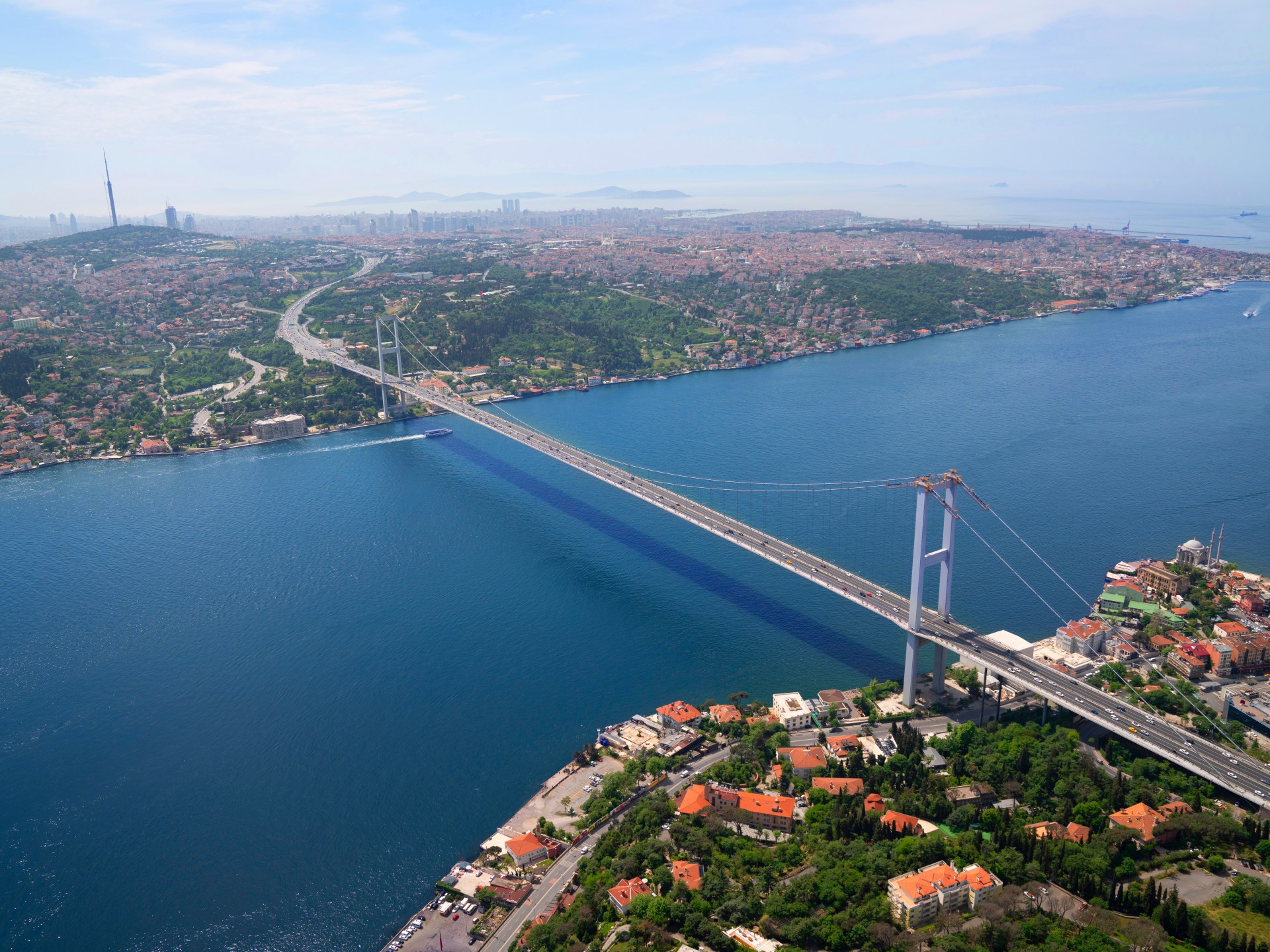
Bosphorus Bridge "July 15 Martyrs Bridge" is one of the first to be built over the strait (Getty Images)
Bridges and tunnels
3 suspension bridges were built over the Bosphorus to facilitate traffic between the two continents, namely:
- The "July 15 Martyrs" Bridge, which is the first bridge connecting the two banks of the city, was previously known as the "Bosphorus Bridge". Opened on October 30, 1973, it is 1074,39 meters long and <> meters wide, connecting the Ortakoy (on the European side) and Bacal Bakiyi (on the Asian side).
- Fatih Sultan Mehmet Bridge is located 5 kilometers north of the "July 15 Martyrs" bridge. Opened in 1988, it is 1510 meters long and 39.4 meters wide, and extends from the "Siege of Osto" area on the European side to the "Qafa Jiq" area on the Asian side.
- The "Sultan Yavuz Selim" bridge is a milestone in the history of Turkish and international engineering, opened on August 26, 2016, and is 59 meters wide, and contains 10 tracks, 8 of which are for cars, and two for the express train, and rises 59 meters above sea level, and connects the "Sariyer" area on the European side, and the "Beykoz" area on the Asian side of Istanbul.
Two tunnels extend under the Bosphorus:
- The Marmaray Tunnel, which opened on October 29, 2013, is the world's deepest tunnel for underwater railway systems, and is intended to cross the train connecting Asia to Europe in 4 minutes.
The Eurasia Tunnel, opened at the end of 2016, is the world's first two-storey undersea tunnel, 14.6 kilometers long, connecting the Asian and European sides of Istanbul.
Treaties
The strait has been under the control of the Ottoman Empire since 1453, and it allowed the passage of Turkish ships or sailing in the service of Turkey, and due to its important strategic location as a corridor for international transport, and the only waterway for the crossing of commercial and military ships coming from or heading towards the Black Sea, many countries aspired to obtain the privilege of crossing or controlling it.
Therefore, many bilateral treaties were signed with the Ottoman Empire or international treaties that were intended to control or obtain privileges in the strait, or to regulate the movement of merchant and warships transiting it.
In 177.4 the Treaty of Kuchak Kınarci was signed, through which the Russian Empire was able to break the Ottoman monopoly on the Black Sea, as the treaty guaranteed it the right of navigation in the strait, but only after its ships were subject to arrest and inspection.
By 1800, this limited and conditional privilege had also been obtained by the important trading powers and all countries wishing to benefit from it, as the Ottoman Empire recognized the right of passage of foreign merchant ships through the Turkish straits, including the Bosphorus, but this right did not extend to warships.
In 1841, an international agreement was concluded to open the straits to all merchant ships and to warships except Turkish ones, and this right was confirmed in the 1856 Treaty of Paris.
However, in order to assert its sovereignty and ensure its security, the Ottoman Empire restricted ships from passing daylight hours, while obliging them to obtain prior written permission given to the guards of military castles on both sides of the strait.
After World War I and the resulting defeat of the "Axis forces", of which the Ottoman Empire was a part, the Treaty of Sèvres was signed in 1920, and one of its provisions was to demilitarize the Bosphorus Strait and make it an international zone under the control of the League of Nations.
After the end of the War of Independence and the proclamation of the Turkish Republic, this clause was amended by the Treaty of Lausanne in 1923, so that the straits were returned to Turkey, but all foreign ships and commercial shipping were allowed complete freedom of passage through the strait, and restrictions were placed on the passage of warships.
The clauses were then amended again in accordance with the Montreux Treaty, which granted Turkey the right to fully control the Bosphorus and Dardanelles, ensure passage for civilian ships in peacetime, restrict the passage of naval ships that do not belong to Black Sea countries, and gave Turkey the right to close sea lanes in case of war or anticipated dangers.
The former Soviet Union has repeatedly demanded the amendment of the Montreux Treaty so that all Black Sea countries participate in the supervision of navigation in the Turkish Straits, and this demand includes the internationalization of regional waterways to ensure that they remain open to Soviet merchant and warships in times of peace and war alike, but these demands were rejected.
Therefore, Russia resorted to strengthening cooperative relations with Turkey in order to ensure Russian freedom of navigation in the Bosphorus and Dardanelles, and to banish the specter of international isolation.
The Bosphorus Strait has historically been a point of conflict between countries due to the importance of its strategic location (Shutterstock)
Risk
Increased freight traffic through the Bosphorus has increased fears of major accidents that could have serious consequences.
Due to the very narrow width of the strait in some parts of it, its sometimes shallow depths, its steep winding beaches, its strong surface currents and the formation of vortices, in addition to the speed of the winds coming from the north and the spread of fog at some times of the year, all of this makes it difficult and dangerous to sail at times.
The increase in the number of ships transiting the strait, coupled with an increase in their size and the different type of cargo they transport, has also led to threats to the strait's natural environment.
As a result of the development of the ship industry, its size and tonnage have increased, as well as the proportion of ships carrying dangerous goods such as crude oil and its derivatives, which results in pollution of the strait's waters and the air of the surrounding environment, and the levels of fishing are negatively affected, with the possibility of explosion and fire.
Turkish concern about accidents and increased pollution led to the preparation of the Straits Regulation, which aims to ensure the safety of lives, property, the environment and navigation in the Turkish Straits, which entered into force in 1994.
However, some countries have carried out an intensive campaign aimed at changing the rules and stopping the procedures applied in accordance with the regulations, claiming that they contradict the Montreux Convention and international navigation rules. However, the four-year objections were not accepted by the International Maritime Organization's (IMO) Maritime Safety Committee (MSC), which decided in May 4 that the traffic regime applied in the Turkish straits was "effective and successful" in enhancing navigational safety.