
The Kingdom of Sheba is located in Marib, east of the Yemeni capital, Sanaa. It is one of the ancient kingdoms in the Arabian Peninsula, and one of the ancient civilizations that dominated the trade routes between India and the civilizations of the Levant and the northern Mediterranean. Listed by the United Nations Educational, Scientific and Cultural Organization (UNESCO) in the World Heritage List.
And now Yemen has 5 places included in the list, namely: the ancient city of Sana'a, the historical city of Shibam Hadramout, the city of Zabid and the island of Socotra, in addition to the landmarks of the Kingdom of Sheba, and all of these sites are endangered due to war, torrential rains, or human neglect.
The UNESCO decision stressed sending a mission to study the reality of those monuments and to prepare plans to protect them in accordance with the provisions of international treaties and laws.
According to the representative of Yemen in the organization, Muhammad Jumaih, the landmarks of the Kingdom included in the list include the following:
The Kingdom of Sheba is located south of the current city of Marib, on the left bank of Wadi Thana (Shutterstock)
The land of the two heavens
The Kingdom of Sheba was also called the "Land of the Two Gardens" for many centuries, and it is located south of the current city of Ma'rib on the left bank of Wadi Dhana, and during its stages of development it became one of the largest cities in the Arabian Peninsula and an important station in the commercial "frankincense road" that linked the port of Qena on the Arabian Sea in South and the port of Gaza on the Mediterranean Sea to the north.
The exact date of the establishment of the city is not known, but it played a major role in the prosperity of the civilization of Sheba, and influenced religion, thought, politics and economics in the civilizations of the ancient world.
According to the Yemeni historian Youssef Muhammad Abdullah, in his book "Papers in the History of Yemen", the ruins and ruins scattered today that surround the small village of Ma'rib indicate the enormity and greatness of the city, which Ptolemy the Alexandrian geographer considered the center of the first climatic region on Earth.
The Yemeni historian adds that the area of the city was about 110 hectares, surrounded by a wall one meter wide and 4.5 kilometers in circumference, with 8 gates permeating it.
The city was destroyed with the collapse of the Marib Dam and the decline in agriculture;
Forcing its inhabitants to migrate north to the center and north of the Arabian Peninsula, and the emergence of the Himyarite state as a striking force and the conflict between the two kingdoms marked the beginning of the demise of the Kingdom of Sheba and its capital in the second century AD.
However, the city did not end, but remained to maintain its religious status and special place, and historical studies speak that it remained inhabited until the beginning of the eighth century AD.
The city's temples and palaces (it is believed that one of them is the Selhin Palace) are still in ruins, but war and neglect destroyed large parts of it, while historians and researchers estimate that large parts of those evidence are buried in the sand.
Due to the magnitude of the Ma’rib Dam, legends appeared around it saying that the giants of the people of Ad built it (Shutterstock)
Old Ma'rib Dam
The dam represents one of the most important and oldest advanced irrigation systems and engineering wonders of the Sabaean civilization. Legends were woven into its construction, as the hugeness of its stones made people say that those who built it were giants from the people of Ad.
Thanks to the dam, the city of Marib turned into one of the metropolises of the ancient world, and at the beginning of the first millennium BC, the Yemenis adapted the environmental conditions of the desert and their ancient experiences in irrigation to build it, as they closed the valley on which it was built with diversionary dams.
Recent studies have inferred that these dam drains indicate that this was the result of the development of an old urban thought in controlling water.
The beginnings of the construction of the dam were to seize parts of Wadi Thana between the northern and central Balak mountains;
By building paved sills of stones and mud in the form of longitudinal walls to break the severity of the torrent and mitigate its strength, and a type of this primitive architecture style was found in the southwest of the valley.
After the completion of the construction of the dam, the water flow was controlled by means of drainage channels in the north and south, leading the water to secondary channels through the fields.
The silt resulting from the dam contributed to the expansion of fertile lands, and agriculture turned into an economic resource for the Sabaean civilization and a factor of stability over many centuries, as it irrigated a vast area estimated at more than 72 kilometers, and at the same time the dam was a threat factor.
Its collapses were repeated due to the accumulation of silt deposits in its basin.
The dam was repeatedly repaired, and according to a study by the Arab Center for Cultural Studies, the dam was demolished due to obsolescence and was repaired more than 8 times, and that the famous incident of demolition occurred between the third and fourth centuries AD.
According to the study, the collapse is also due to the internal conflicts in the Kingdom during the Himyarite era until the dispersal of the state and the emigration of Yemenis, especially after the Abyssinian occupation of Yemen.
Only some features of its walls remain from the old dam, as parts of it were destroyed due to the mutual bombing in the Yemeni war.
The Awam Temple was the main pilgrimage site for the Sabaean tribes and from the Arabian Peninsula, and it was a scene for religious rituals (French)
Awam Temple
It is also called "Muharram Bilqis", and it is the temple of "the god Al-Maqah" (the moon god for whom temples were built inside and outside Yemen, and there are more than 35 temples), and it was the main pilgrimage for the Sabaean tribes and from the Arabian Peninsula, and it was a scene for sacrifices and religious rituals, and in that Time represented the largest religious complex in southern Arabia.
It is located 5 kilometers southeast of the Old City, its main entrance is in the northern façade, and 10 meters from the entrance there are 8 large columns in one row, and the results of archaeological work indicated that it was built in the middle of the second millennium BC.
The temple is a high oval building, the perimeter of its wall is 300 meters, its width is 5.3 meters, and its height is more than 15 meters. It is built of polished and carefully welded stones.
The temple remained until the fourth and fifth centuries AD, and hundreds of inscriptions discovered in it tell of its religious and political importance.
According to the local site of Marib Governorate, more than 300 inscriptions were discovered, including what is legal, economic and social, as well as religious and military, in addition to an archaeological library that represents one of the largest historical documentation libraries.
According to the American Foundation for the Study of Humans mission, which worked at the site in 2004, the Awam Temple is an amazing discovery.
However, today the temple has nothing left except for the remnants of the nails that fixed the inscriptions in the walls, while most of the inscriptions and antiquities discovered there were bulldozed, destroyed, looted and neglected, and are being sold in international auctions.
Barran Temple was considered the largest Yemeni temple before Islam (French)
Bran Temple
The Bran Temple is the most famous archaeological site, known to the public as the "Bilqis Throne", although it has nothing to do with it. It is surrounded by a square fence built with symmetrical stones, in the middle of it is a well, then a staircase leading to 6 columns, each of which is more than 12 meters long, crowned with crowns. Ornate, each cut out of a single stone.
Behind it is the Holy of Holies, which included the statue symbolizing the god "Al-Maqah," according to what the director of the Antiquities Authority in Marib, Sadiq Al-Salwi, told Al-Jazeera Net.
According to historians, the temple represented the largest Yemeni temples before Islam, and its name was derived from the triple root of the Sabaean lexicon (baraa), meaning shady or built, and also on exoneration, that is, getting rid of sins or diseases, to denote the well of holy water in which it is located.
The water was flowing into a stone basin by means of a gutter in the form of a bull's head, while the courtyard was surrounded by galleries from the north, west and south, which included alabaster seats, and from the open courtyard there was a staircase leading to the Holy of Holies behind the six columns.
Historical sources say that the temple lost its value since the fourth century AD after the Yemenis converted to the monotheistic religion.
Despite its engineering uniqueness and historical value, the temple is neglected, and from time to time campaigns appear on social media calling on the authorities and site visitors to stop tampering with it.
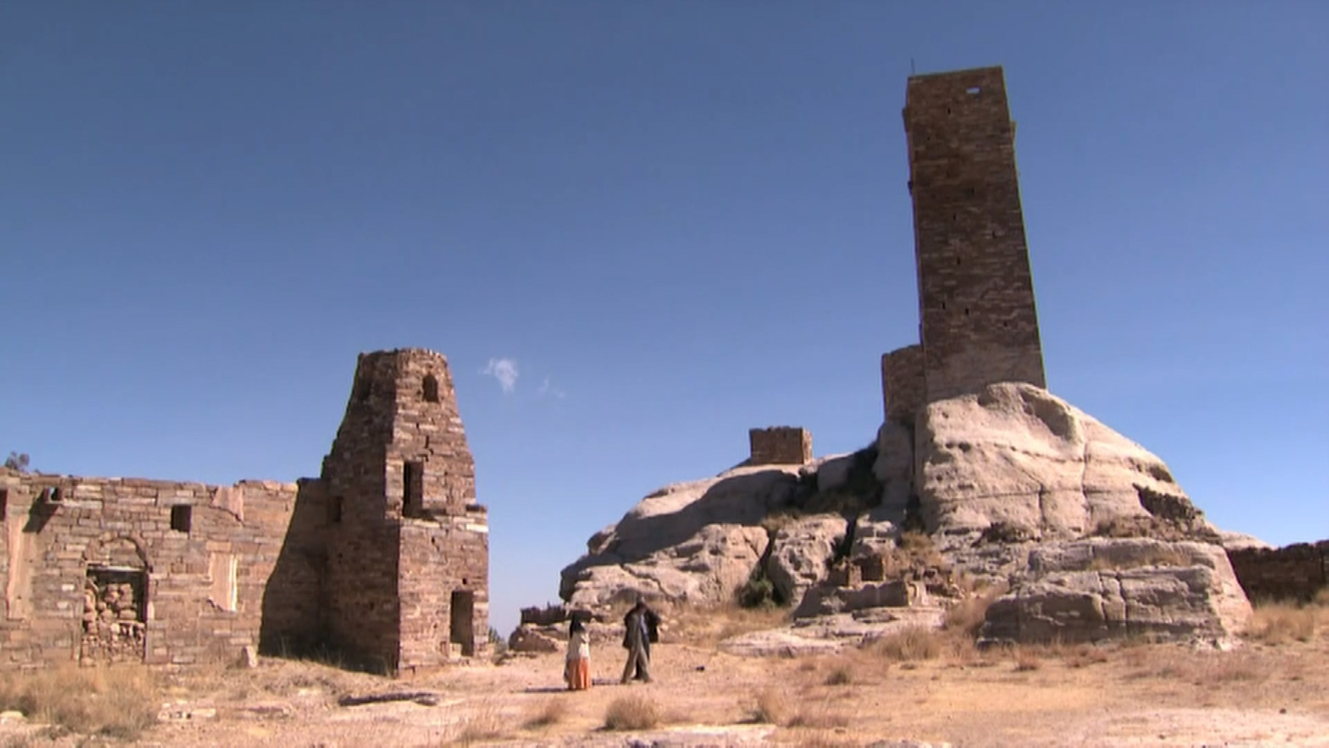
The city and temples of Sirwah were a place related to the ancient religious rituals of the Sabeans (Yemeni press)
Serwah city and its temples
The city of Serwah occupied the second place after Marib in relation to the Kingdom of Sheba, as it had some of the necessary ingredients for the political capitals, because it was established in a semi-circular fertile valley that guaranteed it its agricultural demands and some of its resources, and surrounded it with some highlands, which ensured its natural immunity.
The city, with its dilapidated temples, is still a witness to a history deep in the past, and it is located 40 km west of Marib. Remnants of parts of its wall and ancient buildings appear on the surface of the city, while most of its ruins remained covered in rubble until it was recently revealed.
The remains of the temples are evidence that Serwah was a sacred city for the Sabeans as well, as inscriptions were discovered in it that illustrate some aspects of ancient religious rituals.