
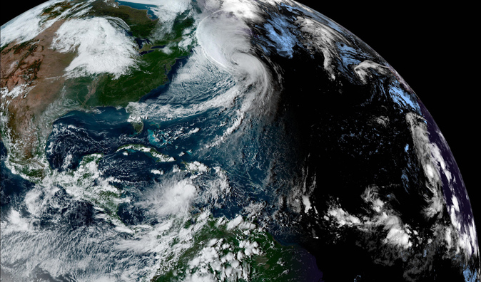
Cyclone Hermine has pulverized several precipitation records in the Canary Islands in three days.
In almost all the meteorological stations, the rain of these days has far exceeded what had been recorded historically in any other month of September.
In other words, more water has fallen
than in a whole month
in a large part of the archipelago;
and, in some places,
almost as much as in a whole year
.
The cyclone, which yesterday already lost its tropical category and had begun to disperse, will leave numerous records when the official data arrives.
Among them, there will probably be a maximum rainfall for this month in the Canary Islands as a whole, since the rain has been unusually intense throughout the territory, from Lanzarote to El Hierro.
In fact, the State Meteorological Agency (Aemet) already collected
numerous record highs
yesterday throughout the archipelago.
“It has been an extraordinary episode of rainfall. Data from the stations of the secondary network have yet to be incorporated, which will be incorporated when the balance for the month of September is made,” explains
David Suárez
, spokesman for the Aemet in the Canary Islands.
"Although, without a doubt, this situation is going to leave us quite a few records and will probably cause September 2022 to be
the wettest since we have data
," he advances, always with the precaution of waiting for the definitive data.
“But, obviously, it has been a historical situation.”
During the storm, and until 06:00 on Monday, a total of 95 liters per square meter accumulated in Santa Cruz de Tenerife, "which makes this month of September 2022 the rainiest in the chicharrera capital since, at least , 1924", as reflected from Madrid
by Rubén del Campo
, also a spokesman for Aemet, who recalled that, at that station, "until now, the rainiest month of September had been 1962, with 62 liters per square meter".
But there are many more records: in Gran Canaria, 118 liters per square meter were measured, while the previous maximum for all of September was 85 litres.
The same in La Palma, where the cyclone has left 134 liters per square meter and the peak for all of September was 58. In Fuerteventura, 60 liters per square meter, which is
more than three times the previous record for September
, 18 litres.
Also in Lanzarote: 48 liters per square meter, when the peak was 14. «We are going to the other end of the archipelago and, at the El Hierro airport, we are also facing the rainiest September of the series, with 48 litres» Del Campo stressed.
«These data are only those due to the storm caused by Hermine, but there are areas of the Canary Islands where, throughout September, there have also been other precipitations.
Therefore, we are facing
an exceptional month of September in the Canary archipelago
», summed up the spokesman for Aemet, who described the episode as «historic».
“Yes, it has been historic.
During this episode some records have been broken and
amounts close to those that are usually accumulated during an entire year
have been recorded », agrees
Mar Gómez
, doctor in Physical Sciences and head of meteorology at Eltiempo.es, who also highlights the rainfall recorded in some points of La Palma, such as the measures in La Sabina or El Pueblo during Sunday.
The question that arises, after verifying the strangeness of the episode, is: will they be more and more common now?
There are signs that point to this.
Since 2005, when tropical storm Delta hit, the frequency of cyclones over the Canary Islands has increased significantly, says Suárez: «I co-supervised a final degree project this past year, with the theme of a retrospective analysis of the impact of tropical cyclones in the Canary Islands.
We analyzed all the cyclones that had passed within a radius of 1,000 kilometers over the Canary Islands and we saw that,
from Delta until now, we have had several examples of cyclones
that have surrounded the waters of the Canary Islands », he details.
"We saw that
there was an upward trend in our region
," completes the Aemet spokesman.
"We have very close cases," he recalls, although he adds that Hermine has been a "very striking" case.
Not only because of the intensity, but “also because of its origin, and how it has moved north from its formation.
She has not had the usual training in the waters of the Caribbean, but has had it close to the African coast.
That is not usual, it has caught our attention.
Could climate change be behind this upward trend?
"Evidently,
one of the causes pointed to by the increase in tropical cyclone activity is global warming
, because one of the factors is that the temperature of the sea water is warmer and the environmental conditions may be more favourable," Suárez weighs. , although he clarifies that, in the case of the Canary Islands, the statistics still offer "few cases to draw a robust conclusion."
A climate with more and more extreme phenomena
The influence of climate change on the frequency and intensity of cyclones and hurricanes is a subject that scientists are still debating and on which it is expected that there will be more and more evidence.
The current consensus is that "hurricanes are likely to cause
more torrential rains
and have a
higher risk of flooding
", while "the global frequency of storms could decrease or remain the same, but hurricanes will be more likely to be intense", as summarized scientist Angela Colbert on NASA's Global Climate Change website.
"It is very likely that the hurricanes will intensify and be of a higher category, but, right now, as regards cyclones
in peninsular or Canary latitudes, we do not have enough evidence
," explains Gómez.
"We do know that climate change is going to intensify extreme weather events, including intense flooding in our country and heat waves," he concludes.
Conforms to The Trust Project criteria
Know more
Environment