
At least 83 people were killed in 5 central and southern states of the United States and the south due to hurricanes and storms, which President Joe Biden described as an "unimaginable tragedy."
Pictures and videos on social media yesterday, Saturday, showed buildings destroyed by the storm, while twisted iron bars, uprooted trees and stones were scattered in the streets, leaving behind destroyed house facades.
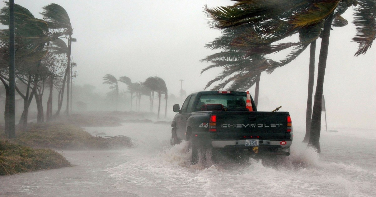
Several Kentucky counties were damaged by the most powerful hurricane ever, with winds exceeding 300 kilometers per hour.
Mayfield, a city of 10,000 people, was the worst-hit in the state.
Hurricanes are an evolution of the strength of the storms. When the storm intensifies, it is classified as a hurricane, and when the hurricane calms down, it becomes a storm.
Hurricane.. what is it?
It is a violent spiral rotating air storm, which is formed from a group of thunderstorms, and represents the largest type of tropical or tropical storm, and the storm is called a hurricane when its wind speed exceeds 119 km / h.
Hurricanes arise over the warm waters of the oceans of the tropics (Atlantic, Pacific and Indian) located between latitudes 5 and 20 north and south of the equator, especially in summer and autumn.
They are known as tropical or tropical cyclones or cyclones because cold air of high pressure revolves around a static center of warm air of low pressure.
Hurricanes in the northern hemisphere rotate counterclockwise, and in the southern hemisphere rotate clockwise.
How do hurricanes form?
When water in tropical seas heats up to a temperature between 27 and 30 degrees Celsius, it heats up the layer of air adjacent to it.
By heating it, the air pressure decreases, so it expands and rises to the top, creating a low pressure area.
Winds are attracted to the low pressure area of high temperature from the surrounding high pressure areas with low temperature.
This attraction leads to the evaporation of water in abundance, and this light vapor rises to the top in the middle of the cold air in a continuous accumulating process that leads to an increase in its lift to the top, and an increase in its charge with more water vapor.
Water vapor begins to condense and cool, forming very cold water droplets, and both cold grains and ice crystals.
As soon as the accumulation stops, rain begins to fall, and this precipitation may be accompanied by lightning and thunderstorms, torrential rain, and hail and snow.
With the increase in water vapor condensation, a measure of heat is released which increases the pressure of the air and more rain falls due to it.
By repeating these processes, the size of the low pressure area over the tropical seas increases, and this confines it between cold areas with high pressure, which increases the chances of cloud formation and accumulation, and thus increases its charge with water vapor.
Air masses with thunder and lightning storms begin to rotate, so a high-speed air storm known as a tropical or tropical storm, a tropical cyclone, a tropical marine or a tropical spiral occurs.
This storm increases in speed to 120 kilometers per hour, and becomes a real hurricane.
hurricane parts
The eye of the storm: or the center area, which is the quietest part, with a diameter of 10 to 50 km, and has the lowest levels of pressure.
Hurricane wall: It is a huge wall of dense clouds and destructive thunderstorms. It revolves around the eye of the hurricane, and its horizontal dimension exceeds 100 km, and is characterized by violent upward vertical air movements. This wall represents the highly turbulent part of the hurricane, and is accompanied by flooding rain, lightning and thunder.
Types of hurricanes
Tropical or tropical cyclones: They are known by local names in the areas of their occurrence: the hurricanes in the North Atlantic Ocean, the eastern Pacific Ocean and the Caribbean Sea, the typhoons in the western North Pacific Ocean and the Philippines, and the cyclones in the Indian Ocean and the South Pacific Ocean.
They are large rotating cyclones with low pressure, and the formation of tropical cyclones is limited to specific areas of tropical seas whose surface water temperature exceeds 27 degrees Celsius between latitudes 5 and 20 degrees north and south of the equator, and they never form over land, with the exception of the South Atlantic Ocean. in which such hurricanes do not form.
As soon as these hurricanes reach land, they begin to fade, and they decay and end if they move over cold water surfaces, and these hurricanes may last up to 3 weeks.
These hurricanes are recorded in the North Atlantic Ocean between July and October, the eastern North Pacific and the North West as well, and are recorded in the south of the equator between November and March, and the hurricane season begins in the Indian Ocean region between the months January and March.
The diameter of the tropical cyclone ranges between 320 and 500 km, and in some cases reaches a thousand km, the air flows around its center in a swirling motion at a speed of more than 100 km / h, sometimes reaching more than 300 km / h.
Tropical cyclones are classified as 5 degrees on the Saffir-Simpson scale, and hurricanes greater than 3 are considered major or significant hurricanes.
Sapphire Simpson scale
First Class: Wind speed from 119 to 153 km/h.
Class Two: from 154 to 177 km/h.
Class III: from 178 to 209 km/h.
Fourth degree: from 210 to 249 km/h.
Class 5: Very high wind speed exceeding 250 km/h.
tornadoes
Also called a cyclone, tornado, whirlwind, spiral cyclone or giant thunder cells, it is a strong spiral storm wind that rotates at a speed of more than 500 km / h, and it is one of the most violent and destructive hurricanes on Earth, and it appears in the form of a rotating funnel cloud emerging from the bottom of an accumulated mass From thunderclouds, some of these cones do not reach the ground, while others hit the surface of the ground, rise and then hit the ground again.
The occurrence of tornadoes is limited between 15 and 45 latitudes north and south of the equator, and extends from Texas in the south to the borders of Canada in the north. Farms, facilities and infrastructure, as well as strikes in Australia and Russia.
The tornado is characterized by its limited horizontal extension, with a diameter of one hundred meters and up to two kilometers, and a distance ranging from a few hundred meters to more than a hundred kilometers, and the tornado lasts from a few minutes to several hours, and the atmospheric pressure inside it reaches one tenth of the atmospheric pressure.
Tornadoes destroy almost everything in their path, and cause buildings to explode as a result of the vacuum resulting from the pressure difference between inside the hurricane and inside the building, where a tornado is accompanied by a sudden drop in pressure, as it carries cars and other large objects to great distances.
If this hurricane moves from land to any water surface, it raises the water to the top in the form of giant fountains known as water meteors or water columns, which are considered dangerous to navigation, destroy the ships that collide with them, and may lead to their sinking.
Most of these hurricanes are recorded between April and July, and the "Fujita Scale" is used to measure the speed and size of damage and losses caused by tornadoes.
The names of hurricanes .. How did they start?
Meteorologists have long known that naming tropical storms and hurricanes with short, distinctive names helps people receive and share detailed storm information from hundreds of television stations, coastal bases, and ships at sea, as storms are remembered, helping people stay largely safe.
The use of names also greatly reduces confusion when two or more tropical storms occur at the same time.
While people have been giving names to major storms hundreds of years ago, most hurricanes were originally named by a system of latitude and longitude numbers, which was useful for meteorologists trying to keep track of these storms, but this system was confusing for people who live on Coasts in search of hurricane information.
In the early 1950s, a formal practice of naming storms in the Atlantic Ocean was first developed by the US National Hurricane Center.
At that time, storms were named according to the phonetic alphabet, such as "Able", "Baker" and "Charlie", and the names used were the same for each hurricane season, in other words, the first hurricane of the first season was always called "Able", and the second "Baker" ', and so on.
1953: To avoid frequent use of names, the system was revised so that storms are given female names, in a simulation of marine meteorologists who named ships at sea after women, and the first storm to receive a female name was Tropical Storm "Alice".
Since the end of 1978, the system has been revised again to include alternating male and female hurricane names. The first storm to bear a male name was Hurricane Bob, which hit the Gulf Coast of the United States in 1979.
How are the names chosen?
Scientists call hurricanes proper names for easy identification and follow-up.
Nouns are pre-prepared, alphabetical (in English) lists of alternating male and female names.
When a hurricane is formed, it is named according to its role, and this name remains with it until it vanishes, and so on.
The list includes about 160 names, and when the distribution of names runs out, the name is repeated from the same list.
If the hurricane is highly destructive and the number of deaths caused by it is high, that name shall be considered ominous and shall be crossed out from the list and replaced with another name of the same gender and with the same crossed out letter to preserve the alphabetical order of the list of names.
Experts assign names to hurricanes according to an official list of names approved before the start of each hurricane season. The US National Hurricane Center began this practice in the early 1950s, and the World Meteorological Organization (WMO) now creates a list of hurricanes and conservation on her.
The organization issues a set of 6 lists of 21 names - one for each letter except for "Q", "U", "X", "Y" and "Z" - For use every year in the Atlantic Ocean, the West Coast gets hurricane names from 6 different other lists that include all letters of the alphabet except "q" and "u".
Every time a tropical storm strikes, meteorologists take the names alphabetically in that year's list. It should be noted that the names of storms do not tell you about the nature of storms, their function is to determine the category of names only.
Once 6 years have passed, the label begins again with the first list. For example, the first tropical storm in the Atlantic Ocean for this year was named "Andrea", and this name for the first hurricane will be in 2025 as well.
If there are more than 21 tropical storms in one year (or 24 in the Pacific Ocean), the rest of the names come from the Greek alphabet, starting with alpha and going down to omega. There was a very bad storm.
Why are some names deleted?
Only when a hurricane is exceptionally catastrophic is its name removed from the list of hurricane names for legal, cultural and historical reasons, for example the use of the name "Katrina" was discontinued in 2005 after the devastating impact of Hurricane Katrina in New Orleans, and for this reason we will not see the name of a hurricane Another "Katrina" or "Sandy" in the future.
The World Meteorological Organization decides whether to withdraw any names from the list at its annual meeting.
The organization has removed names such as Katrina (2005), Joaquin (2015), Irma (2017), Maria (2017) and Florence (2018), and if a name is removed, the organization replaces it with a new name, for example, the list of hurricane names for the year 2011 appeared containing the name "Catia". An alternative to Katrina.
The names that were recently withdrawn from the Atlantic Ocean list as of September 2019 are "Florence" and "Michael", and were replaced by "France" and "Milton", as Hurricanes Florence and Michael hit the coasts of North Carolina and Florida, respectively. 2018 in severe damage and dozens of deaths.