
China Weather Network News. In the next three days (November 17-19), affected by the combined effects of cold air and warm and humid air, my country’s central and eastern regions will usher in a large-scale rain and snow weather, including the southern part of Northeast China and eastern Huanghuai. The daily precipitation on the ground may exceed the historical extreme value during the same period.
This weather process has a wide range of rain and snow and strong intensity. The northeast region not only has strong rain and snow, but also has strong gusts and winds. The roads are easy to freeze. Public travel needs to pay attention to safety.
Many places in the central and eastern regions will welcome the "seasonal cooling", and the cumulative cooling in the northeast Jiangnan can reach 10℃
Recently, most areas of our country are dominated by sunny and dry weather, and warmth returns. The fog and haze in the North China Plain have "stitched". Among them, yesterday, Beijing, southern Hebei, northern Shandong, northern Henan, and central Shanxi showed moderate haze. This morning, heavy fog appeared in parts of southern Shanxi, southern Beijing, southern Tianjin, southeastern Hebei, northwestern Henan, central and western Hubei, central and northern Hunan, and central and western Guangxi. Local visibility was less than 200 meters.
Yesterday, Beijing experienced light to moderate pollution and poor visibility.
(Photo/Wang Xiao)
However, affected by the cold air, there will be obvious windy weather in the central and eastern regions of my country. Starting this afternoon, under the combined influence of precipitation and cold air, the haze weather in the central and southern parts of North China, Fenwei, and western Huanghuai gradually weakened and dissipated from west to east.
In the next three days, the temperature will drop by 8-10℃ in North China and the central and southern parts of Northeast China, and the local temperature will reach above 10℃; the above-mentioned areas will be accompanied by winds of magnitude 4 to 6, and gusts of magnitude 7 to 8, northeast China, Yellow Sea, Bohai Sea The gust can reach level 9 or above.
After the cooling, most of the northern part of China will reverse the previous pattern of obviously warmer temperatures, especially the difference between the warm and cold before and after cooling in the northeast will be very large.
In provincial capital cities, for example, the highest temperature in Shenyang today is around 16°C, but it will drop to 3°C on the 20th; the highest temperature in Changchun today is 13°C, and it will drop to -1°C on the 20th.
The above-mentioned cities will all experience a "seasonal" cooling, and the local public should pay attention to adding clothes in time.
As for the South, before the cold air is affected, it will be affected by the strong warm and humid air. The temperature in Jianghuai, Jiangnan and other places will continue to rise. The maximum temperature will generally rise above 25°C tomorrow, and some areas will even rise. Above 30℃, it feels like returning to September.
In provincial capital cities, such as Hefei, Nanjing, Nanchang, and Changsha, the highest temperature will rise to around 30℃ on the 18th, or the warmest day in the history of meteorological observation in mid-November.
However, as the cold air deepens southward, there will be obvious temperature fluctuations in Jiangnan around the 20th, and the above-mentioned areas will return to 20°C again.
In Northeast Huanghuai and other places, strong rain and snow or extreme low temperature and easy icing need to pay attention to traffic safety
At the same time, in addition to the strong wind and cooling, the cold air process will also bring a strong rain and snow weather process to the central and eastern regions, especially in the southern part of the Northeast region, the eastern part of Huanghuai and other local daily precipitation may exceed the historical extreme value of the same period.
Among them, the precipitation in Northwest, North China, Huanghuai and other places will be concentrated on the 17th to the 18th, while the main precipitation period in the Northeast is from the 18th to the 19th.
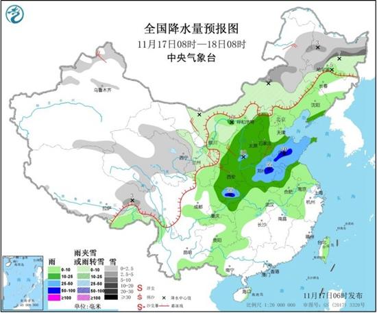
Specifically, the Central Meteorological Observatory predicts that the rainfall in Sichuan, Chongqing and Huanghuai will increase significantly starting today. Heavy rain will occur in parts of southwest Shanxi, most of Shandong, central and northern Henan, northern Chongqing, and northeastern Sichuan. Among them, there were heavy rains in western Shandong, eastern Henan, and northern Chongqing.
In addition, there are light to moderate snow or sleet in parts of northern Xinjiang, most of Inner Mongolia, central and northern northeast, eastern and southern Qinghai, and eastern Tibet. Among them, there is heavy snow in central and eastern Heilongjiang and central and eastern Inner Mongolia. .
Tomorrow, the rain and snow weather in Northeast and North China will be significantly enhanced. Among them, there will be light to moderate snow or sleet in parts of central and eastern Inner Mongolia, central Northeast China, northern North China, and eastern Qinghai-Tibet Plateau. Among them, central Inner Mongolia and southeastern Heilongjiang Some areas in other places have heavy snowfall.
There were moderate to heavy rains in parts of central and eastern Jilin, most of Liaoning, eastern North China, most of Shandong, southern Jianghuai, and northern Jiangnan. Among them, there were heavy rains or heavy rains in parts of southern Jilin and eastern Liaoning.
Meteorological experts reminded that in the next three days, affected by the cold air, rain and snow will increase in most parts of the central and eastern parts of my country, especially in Inner Mongolia and northeastern regions, where the temperature is relatively low. The public should pay attention to preventing roads caused by rain and snow The adverse effects of slippery, icy and low visibility weather on traffic travel.