
China News Service, February 26. According to the website of the Central Meteorological Observatory, from 26 to 28, there will be a large range of rain and snow in the central and eastern regions. There were rain to sleet or light to moderate snow in the northwest, north China, northeast, and north Huanghuai. In addition, from the morning to the morning of the 26th, southeast Shanxi, southwestern Shanxi, northeast Sichuan, north-central Chongqing, and Hubei There are heavy fog in parts of the south, southwest Guangxi, and southwest Guangdong, and there are strong dense fogs with a visibility of less than 200 meters.
Data map: Citizens travel on the streets in the snow. Photo by Zhang Yao
Significant rainfall yesterday in Hubei and Anhui
Yesterday, light rain occurred in northern Chongqing, southeastern Shaanxi, most of Hubei, central and southern Anhui, and southern Jiangsu. Heavy rain occurred in Yichang, Tianmen, Xiaogan, Wuhan, Huanggang, and northeastern Chongqing and Anqing, Anhui. Local heavy rains in Wuhan and Huanggang (50-73 mm); light to moderate snow or sleet occurred in parts of eastern and central Tibet and southeastern Inner Mongolia.
This morning, heavy fog appeared in parts of southeastern Shanxi, western Shandong and northeastern Sichuan, north-central Chongqing, and southwest Hubei, with local visibility less than 200 meters.
There will be a large range of rain and snow processes in the central and eastern regions
From 26 to 28, there will be large-scale rain and snow processes in the central and eastern regions. There was heavy rain or sleet or light to moderate snow in the northwest, north China, northeast, and north Huanghuai. Among them, heavy snow was found in central and eastern Inner Mongolia, central northeast China, northern North China, and western China. There will be light to moderate rain in southern Huanghuai, Jianghan, Jianghuai, eastern southwest, and northern Jiangnan. Among them, southern Shaanxi, southern Henan, northern central Hunan, northern Chongqing, eastern Sichuan, eastern Guizhou, and northwestern Yunnan. There was heavy rain in the area.
In addition, from the morning to the morning of the 26th, foggy weather occurred in parts of southeastern Shanxi, southwestern Shanxi, northeastern Sichuan, central and northern Chongqing, southern Hubei, southwestern Guangxi, and southwestern Guangdong, with local visibility less than 200 meters. Strong dense fog. Foggy weather in the eastern waters of Leizhou Peninsula with visibility less than 1 km. The Central Meteorological Observatory continued to issue a yellow warning of heavy fog at 06:00 on February 26.
Specific forecast for the next three days
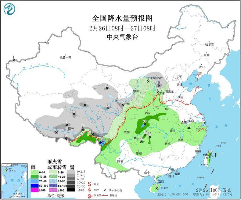
From February 08:00 to February 27, 08:00, there were light to moderate snow or sleet in parts of Hetao, Inner Mongolia, the middle and northeast of the northwestern region, northwest of the mountain, central and eastern Tibet, and northwest of the southwestern region. Among them, Tibet In the eastern part, there are blizzards (10-14 mm). There were light to moderate rain in parts of the northeast, northwest China, western Huanghuai, western Jianghuai, Jianghan, eastern and northern Jiangnan, eastern southwest, central and western Yunnan, and Taiwan Island, among which northeast Sichuan and Yunnan Heavy rains (50-55 mm) occurred in the northwest and east of Taiwan Island. In Liaodong Peninsula, northern Shaanxi, southwestern Shanxi, and Shandong Peninsula, there are 4-6 magnitude winds (see Figure 1).
Figure 1 National precipitation forecast map (08: 27-27: 08 on February 26)
From February 08 to 08:00 on February 28, northern Xinjiang, central and eastern Inner Mongolia, eastern Liaoning, central and western Jilin, eastern Qinghai, northeast of Northwest China, most of North China, north of Huanghuai, eastern Tibet, and northwest of Southwest China Some areas have light to moderate snow or sleet. Among them, heavy snow (5-9 mm) is found locally in Xinjiang Altay and Yili river valleys. There was moderate to heavy rain in parts of the northwest, south of Huanghuai, most of Jianghuai, most of Jianghan, northwest of southwest, and northwest of Yunnan. Among them, heavy rain (50-60 mm) was located in northeastern Chongqing. In areas of central Inner Mongolia, Liaodong Peninsula, Xinjiang along the Tianshan region, and southern Gansu, there were 4-6 winds (see Figure 2).
Figure 2 National precipitation forecast map (08: 28-28 February, 08:00)
From 08:00 on February 28th to 08:00 on 29th, there were light to moderate snow or sleet in parts of Xinjiang along the Tianshan region, northeastern Inner Mongolia, northeast Liaoning, Jilin, central and southern Heilongjiang, and western Sichuan plateau. Among them, Heilongjiang In the south and east of Jilin, there are heavy snowstorms (10-12 mm). There were moderate to heavy rain in parts of the western Jianghuai, eastern Jianghan, northern Jiangnan, and southeast of southwestern regions. Among them, heavy rainfall (50-65 mm) occurred in the eastern part of Guizhou. In areas such as north-central Inner Mongolia, Hexi, Gansu and Shandong Peninsula, winds of magnitude 4 to 6 were observed (see Figure 3).
Figure 3 Prediction map of precipitation in China (08--29 February 08: 00)