
China News Service, February 24th. According to the website of the Central Meteorological Observatory, in the next three days, the middle and eastern part of the Qinghai-Tibet Plateau will be small to medium snow and local snow. Affected by the low-level shear line, there will be a precipitation process in North China, Huanghuai, Jianghan, northern Jiangnan and other places on the 24th to 25th, with light to moderate rain and heavy rain in the area.
Data map: citizens travel in the snow. China News Agency reporter Liu Xinshe
Significant snowfall in northern Xinjiang and other places yesterday
Yesterday, small to medium snow appeared in northern Xinjiang, northeastern Inner Mongolia, north-central Heilongjiang, and eastern Tibet. Local heavy snow (5-7 mm) was found in Tacheng and Altay, Xinjiang. This morning, heavy fog appeared in parts of southwestern Chongqing, northeastern Guizhou, and southeastern Sichuan, and local visibility was less than 200 meters.
Snowfall on the Qinghai-Tibet Plateau and other places
In the next three days, the middle and eastern part of the Qinghai-Tibet Plateau will be small to medium-snow and heavy snow. On the 24th, there was light snow in northern Xinjiang. From 24 to 25, there were light to moderate snow or sleet in parts of eastern Inner Mongolia and northern Hebei.
In addition, from 26 to 29, there will be a significant rain and snow weather in the central and eastern regions. Among them, there will be light to moderate snow or sleet and heavy snow in the northwest, north, and northeast regions.
There will be precipitation in Huanghuai River and Han Dynasty
Affected by the low-level shear line, there will be a precipitation process in North China, Huanghuai, Jianghan, northern Jiangnan and other places on the 24th to 25th, with light to moderate rain and heavy rain in the area.
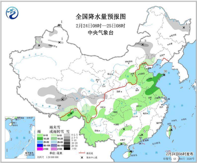
Specific forecast for the next three days
At 08:00 on February 24 to 08:00 on February 25, light snow or sleet was found in parts of northern North China, northern Heilongjiang, northern Xinjiang, central and eastern Tibet, southern Qinghai, and northern Sichuan plateau, and local snow (2.5 ~ 4 mm). There were light to moderate rain and local heavy rain (25-30 mm) in some areas of central and southern North China, most of Huanghuai, Jianghuai, most of Jianghan, east and southwest of China (see Figure 1).
Figure 1 National Precipitation Forecast Map (February 24, 08 to 25, 08 am)
At 08:00 on February 25th to 08:00 on the 26th, light snow or sleet was found in parts of eastern Inner Mongolia, eastern Jilin, northern Xinjiang, most of Tibet, and central and southern Qinghai. Local snow (2.5 to 3 mm) . Light to moderate rain occurred in parts of the northeast, south of Jianghuai, south of Jianghuai, north of Jiangnan, east of southwest, northwest Yunnan, and east of Guangdong.Among them, there were heavy rains in eastern and southern Hubei and southwest Anhui. 25-35 mm). In parts of Liaoning's central and western regions and Shandong Peninsula, winds of magnitude 4 to 5 were observed (see Figure 2).
Figure 2 National precipitation forecast map (February 25, 08 to 26, 08 am)
From 08:00 on February 26 to 08:00 on the 27th, there were light to moderate snow or sleet in some parts of the central and eastern Qinghai-Tibet Plateau, north-central Shaanxi, most of Shanxi, and central Inner Mongolia, and heavy snow (5-8) Mm). There was light to moderate rain in parts of the northwest, east of Huanghuai, Jianghan, north-central Jiangnan, east of southwest, northwest Yunnan, and southeast Tibet. Among them, heavy rain (25-35 mm) was found in the northeastern part of the Sichuan Basin ). In some parts of the Liaodong Peninsula, southern Shaanxi, and Shandong Peninsula, there are 4 to 5 winds (see Figure 3).
Figure 3 National Precipitation Forecast Map (February 26, 08 to 27, 08 a.m.)