
play videoplay video
Video duration: 11 minutes 12 seconds 11:12
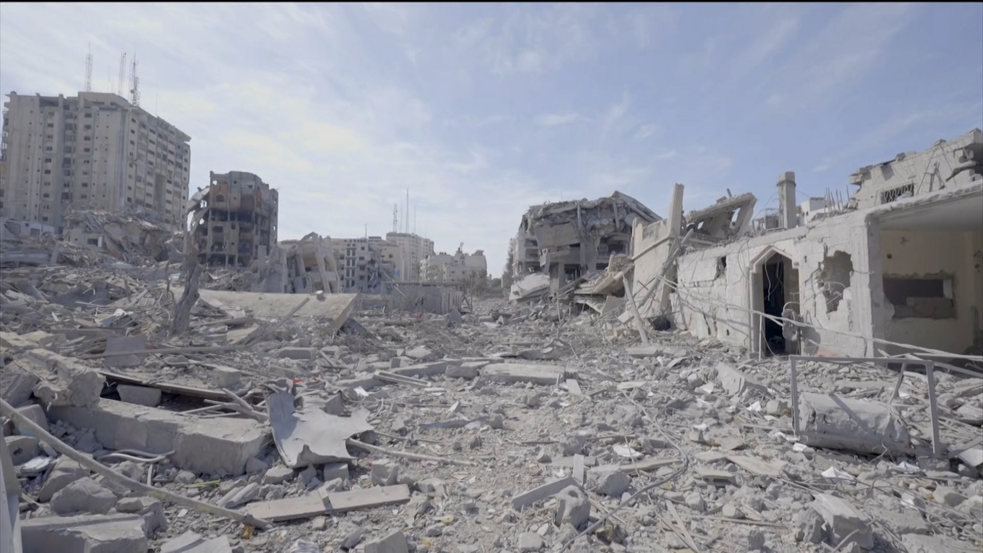
The Israeli newspaper Haaretz used aerial photographs before and after the ongoing war on the Gaza Strip, to indicate the extent of the massive destruction caused by the Israeli army, describing the scenes as similar to what came after the atomic bomb.
In a report entitled “Gaza residents have fled their homes...they have nowhere to return to,” she said, “Satellites reveal the extent of the massive destruction inflicted on the Gaza Strip. The new reality created by the Israeli army’s operations will affect the entire region for many years.”
The newspaper pointed out that hundreds of thousands of Gazans were displaced from their homes and large areas of the Strip were destroyed.
She said that residents, military officials, and journalists described scenes of massive destruction, and one of them (whom she did not name) said after visiting northern Gaza, “It is like what came after the atomic bomb.”
She added that accurately estimating the destruction is a difficult task due to the continuing war, and given that the Israeli army imposes restrictions on the entry of journalists, but it is possible to create a map of the destruction using satellite data, which shows that at least half of the buildings in the Strip are likely to have been damaged. Or destroyed, according to American researchers.
She added that most of the destruction is in northern Gaza, but bitter fighting is also taking place in the south, as satellite data shows.
A bitter human reality
The United Nations says that about 1.7 million Gazans fled their homes during the war, most of them now in the south, and huge tent cities have been set up along the Egyptian border.
The newspaper added, "A new humanitarian, security and diplomatic reality has emerged, and it will shape the region for years to come."
It added that reports of the war widely confirm the destruction of homes, commercial buildings, water and sanitation infrastructure, medical facilities, schools, universities, mosques, churches, shopping malls, stores, food factories, and relief centres. Roads, archaeological sites, and cemeteries were also damaged.
She pointed out that one of the first steps taken by the Israeli army was to order the residents of northern Gaza to head south, stressing that thousands fled quickly, and the aggressive bombing campaign launched by the Israeli army continued without interruption, except for a short ceasefire last November when an exchange of Detained Palestinian prisoners and detainees.
Massive destruction
Haaretz continued, using satellite images, "The Israeli bombing from the air, land and sea quickly caused massive damage throughout the Strip."
The newspaper reported that at least half of the buildings in the Gaza Strip were likely to have been damaged or destroyed as of last January 29, according to American researchers Corey Shear and Jamon van den Hoek, who used satellite analysis to create their map.
She added: The two American researchers pointed out that their map does not show the exact extent of the damage to each building. But it shows that the damage in northern Gaza is the greatest, and that the damage in the south is also great.
She continued: The map shows that massive destruction occurred in Gaza City, where the main concentration of civilian infrastructure in the Strip is located. Even if those civilian buildings were not bombed, they are located in the heart of areas that were subjected to heavy bombing, and it will take significant time and effort for life there to return to normal.
She pointed out that the United Nations indicated that 60% of housing units were damaged or destroyed, according to data since the beginning of this February.
The United Nations says that 390 educational facilities, 20 water and sanitation facilities, 183 mosques and 3 churches were damaged. Government buildings, including the Palestinian Parliament in Gaza, were damaged or destroyed.
The newspaper reported that satellite images indicate, for example, the destruction of the entire eastern part of the Shujaiya neighborhood, east of Gaza City.
She added that the Shujaiya neighborhood is not the only area suffering from such massive destruction, as entire buildings or neighboring buildings were leveled to the ground. There is also Beit Hanoun (north), the Bureij and Maghazi camps, and the towns of Juhr al-Dik (central), Bani Suhaila, and Khirbet Khuza’a (south).
She added that the pictures also show many craters resulting from bombs, "and even the huge Star of David that soldiers dug in the ground near Al-Azhar University in the Al-Rimal neighborhood, which was an upscale neighborhood in Gaza City."
She added that the destruction appears particularly in the areas through which the Israeli army passed, such as the southern entry road for the Israeli army into the Gaza Strip, which is parallel to the coast, and widespread destruction appears in the Al Awda neighborhood in Gaza City, near the coast and next to the Beach refugee camp.
The newspaper pointed out that the Israeli bombing campaign sent hundreds of thousands of people to the south, and for many Palestinians, the flight and displacement from their homes was a shocking repetition of the 1948 Nakba.
Source: Israeli press + Anadolu Agency