
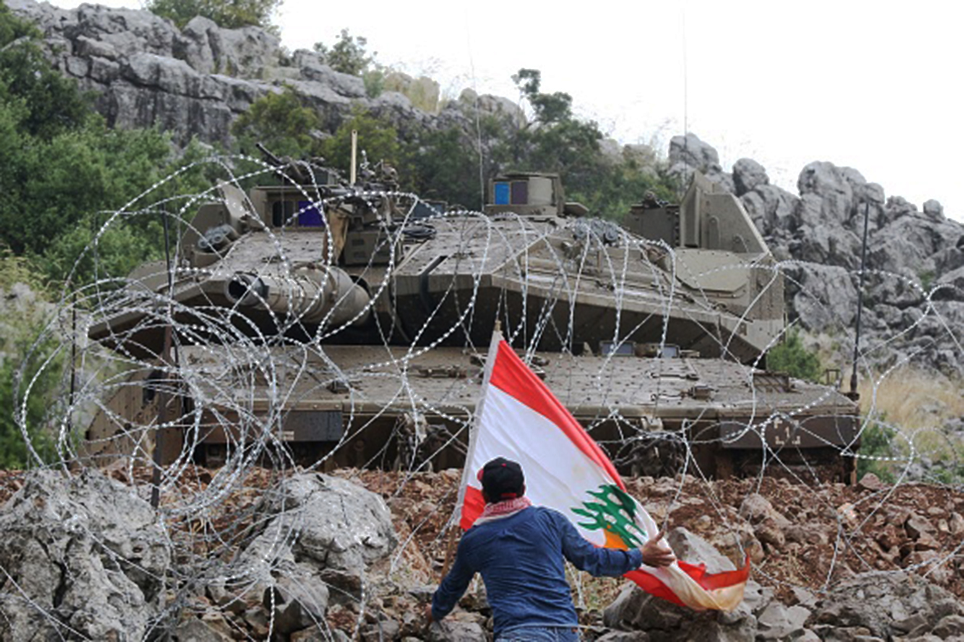
BEIRUT – The security tension in the southern Lebanese town of Kafr Shuba has eased after the intervention of the United Nations Peacekeeping Force (UNIFIL) and the Lebanese Army, following the Israeli occupation army's firing smoke and sound bombs at a group of townspeople who protested against Israeli excavations aimed at annexing their agricultural lands and establishing a new border fence.
The security tension – which lasted on Friday for about an hour – resulted in suffocation injuries among the protesters as a result of the Israeli forces firing tear bombs towards them, while a number of protesters exceeded the barbed wire erected by Israel, and threw stones at its soldiers and vehicles to confirm their resistance to all illegal expansion and annexation operations carried out by Israel.
The residents insist on raising their voice in affirming the "Lebaneseness" of the Israeli-occupied Kafr Shuba hills and Shebaa farms in exchange for refusing to recognize the withdrawal line drawn by the United Nations following the Israeli withdrawal from the south in 2000.
The Lebanese army announced that it was "carrying out a deployment in the border area of Kafr Shuba in the face of the Israeli enemy," while UNIFIL spokesman Andrea Tenenti said UNIFIL was in contact with various parties and was seeking solutions.
Tenenti called on both sides to "exercise restraint and avoid actions that could lead to an escalation of tension along the Blue Line."
UN vehicles near the Blue Line drawn on Kafr Shuba territory since the 2000 Israeli withdrawal (French)
Historical story
The town of Kafr Shuba is located on the southern western foothills of Mount Hermon, and is within the triangle of borders between Lebanon, Syria and historic Palestine, and is linked to the problem of Israel's occupation of the Shebaa Farms, the Kafr Shuba hills and the town of Ghajar in southeastern Lebanon, which are not recognized by the United Nations and Israel as Lebanese, and are treated as Syrian territory.
Following the Israeli withdrawal from southern Lebanon in 2000, a United Nations team demarcated the withdrawal line, known as the Blue Line, along Lebanon's southern border, with the exception of the Shab'a farms and the Kafr Shuba hills.
The United Nations considered that Israel has fully implemented Resolution 425 to withdraw from southern Lebanon, and that the Shebaa Farms are not Lebanese, but Syrian and are under the responsibility of the "UNDOF" forces not "UNIFIL", according to what the Lebanese historian and researcher Dr. Issam Khalifa tells Al Jazeera Net, who has already completed a study of maps of the Lebanese state about this region.
Demarcation
Historically, the Israeli occupation of this area dates back to 1967, and included farms extending about 24 km long and about 13 km wide following the occupation of the adjacent Syrian Golan Heights.
Following the 1978 Israeli invasion of southern Lebanon to the Litani River, UN Resolutions 425 and 426 were issued, calling on Israel to withdraw immediately to the internationally recognized borders, while Lebanon insists that these territories are Lebanese and have been occupied by Israel since 1967.
Another problem for Lebanon lies in another historical issue in terms of the non-demarcation of its land and sea borders with Syria since the French Mandate era in the two countries (1920-1943), which were the same mandate area for France.
However, the real problem is that Syria did not send to the United Nations maps confirming the Lebaneseness of the Shebaa Farms and the Kafr Shuba hills, despite the importance of the issue in resolving the mechanism for implementing UN resolutions there.
However, Syrian President Bashar al-Assad had already acknowledged in 2006 after the "July War" that these territories were Lebanese, but kept their problem pending, considering that the demarcation of the land border there requires first Israel to withdraw from it.
Here, researcher Issam Khalifa recalls the map of 1946 when a border agreement was reached on Shebaa and Maghar Shebaa (Syria) between a Lebanese-Syrian real estate committee, where the borders were drawn and markers were moved on the ground, extending from the north of the Wadi al-Assal bridge to the north of the Lebanese town of Nakhila.
Khalifa believes that there is a deliberate disregard by various parties for the town of Nakhila and the need for Lebanon to defend it, which in his view has strengthened Israel's expansion.
"Lebanon's mistake is that it did not improve its argument to the United Nations with the maps it has and the documents we presented to it," he said.
The historian talks about the strategic importance of the Kafr Shuba hills, which are part of Mount Hermon (Sheikh), and contain a huge water reservoir of about one billion and 200 million cubic meters "supplying occupied Palestine", in addition to the role of this mountain on the military level of Israel, where one of the most important watchtowers in the Middle East was erected, through which they can monitor the entire Damascus.
Analysts say Israel is taking advantage of the lack of permanent UNIFIL patrols in the Kfar Shuba hills and seeking to expand its occupation (French)
Fait accompli
These issues, confirmed by Brigadier General retired Dr. Hisham Jaber, and tells Al Jazeera Net that Israel claims that the hills of Kafr Shuba Syria, while it occupied in 1982 after the second invasion of Lebanon.
Jaber heads the Middle East Center for Studies and Public Relations, and believes that Israel today continues its ambitions through bulldozing and tunneling, taking advantage of the lack of permanent UNIFIL patrols there, and seeking to expand its occupation of Lebanese land owned by Lebanese farmers.
He said that the withdrawal line in this area was imposed on Lebanon as a fait accompli, in addition to Israel's exploitation of UN Resolution 1701 issued after the 2006 "July war", as Hezbollah cannot be present in the southern Litani area.
He explains that in 2001, a new map of Lebanon was issued, modifying the borders of the Lebanese-Syrian-Israeli triangle, and moving it from the Jabal al-Rus-Jabal al-Summaq line to the Wadi al-Assal line from west of Shebaa to the Dan River on the border of "occupied Palestine."
What is the solution?
Writer and political researcher Amin Kammourieh recalls the statement of the Arab summit in Jeddah on Lebanon, which affirmed "the right of the Lebanese to liberate or recover the Shebaa farms, the Lebanese hills of Kafr Shuba and the Lebanese part of the town of Ghajar, and their right to resist any aggression by legitimate means."
Kammouria told Al Jazeera Net, "This item is an Arab recognition of the Lebanese region, and the position can be further strengthened by the completion of the demarcation of borders by land and sea between Lebanon and Syria, despite all the obstacles and political and geographical differences."
While Lebanese sources believe that the United Nations is biased towards Israel in the issue, Kammourieh says that its solution lies in Syria's legal and international affirmation of the Lebanese territories, expecting the state of security tensions in that area between the occupation and the people of Lebanese villages to continue from time to time.
At the same time, historian Issam Khalifa believes that the solution is achieved by preparing the Lebanese government with the relevant minutes, maps and agreements between Lebanon and Syria since the Mandate era in full and presenting them as a damning document of the United Nations.
"Therefore, it can press the demand to separate the Shebaa Farms from Resolution (242) and insist that Resolution (425) is what includes the Shebaa Farms in preparation for their liberation from occupation along with the hills of Kafr Shuba," which in his opinion requires solid Lebanese political will, "but it is absent," he said.