
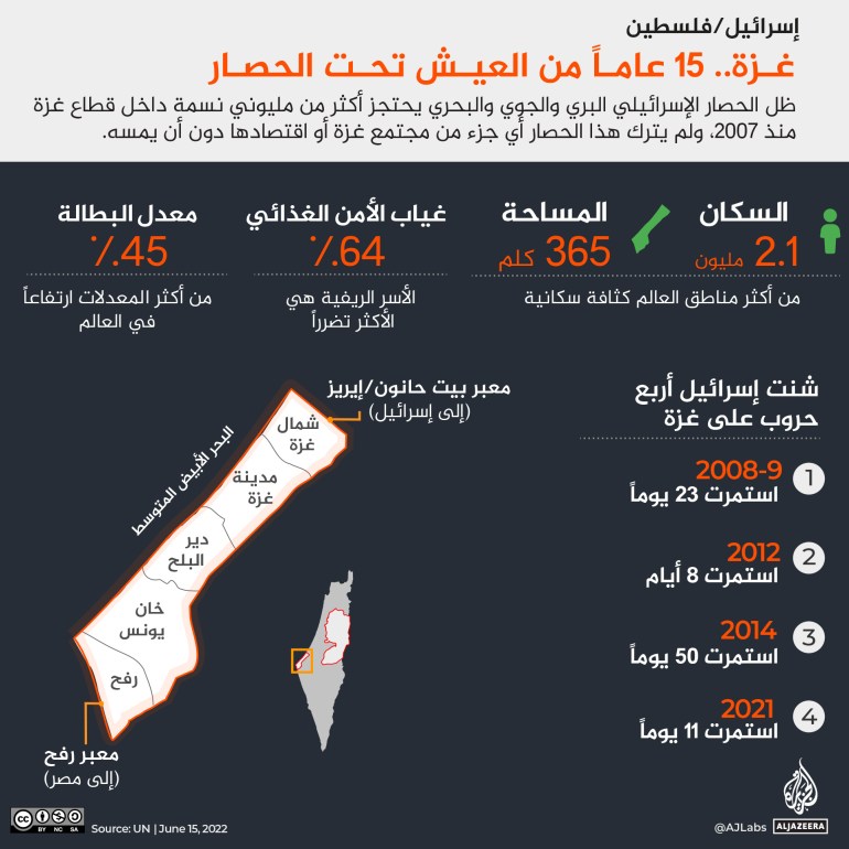
The Gaza Strip, home to 2.1 million people, has been under a land, sea and air blockade imposed by Israel for 15 years.
Israel and the Palestinian Islamic Jihad announced a truce that ended 3 days of Israeli bombing of Gaza, which killed at least 44 Palestinians, including 15 children, and injured at least 350 Palestinian civilians.
Since the start of the Israeli bombardment last Friday, Israel has carried out heavy bombardment across Gaza, razing buildings to the ground and bombing refugee camps.
Islamic Jihad responded by firing rockets at Israel.
According to Israeli media, most of them were intercepted by the Iron Dome missile defense system, and no serious injuries were reported.
In the following series of maps, the island takes you on a journey through the five governorates of Gaza, highlighting key locations, including hospitals, schools, universities, UN compounds, refugee camps, crossings and critical infrastructure facilities.
15 years of the Israeli blockade
Gaza has a population of about 2.1 million.
They live in 5 governorates: North Gaza, Gaza City, Deir al-Balah, Khan Yunis and Rafah.
The sector is bordered by Israel to the north and Egypt to the southwest, on the Mediterranean coast, with an area of about 365 square kilometers.
With a length of only 41 kilometers, the distance from Rafah in the far south of the Strip to Beit Hanoun in the far north can be covered by less than an hour by car.
Since 2008, Israel has waged 4 wars on the Palestinian territories, killing thousands of people, most of them civilians.
During the fourth attack on Gaza in May 2021, according to UN data, at least 261 people were killed, including 67 children, and more than 2,200 were injured.
That 11-day attack damaged at least 51 educational facilities, including 46 schools and kindergartens, a training center for the United Nations Relief and Works Agency for Palestine Refugees in the Near East (UNRWA), and parts of the Islamic University in Gaza.
The Israeli raids also destroyed at least 6 hospitals and 11 primary health care centers, including the only COVID-19 laboratory in Gaza.
Gaza 15 years of living under siege (Al Jazeera)
North Gaza
The northern Gaza region shares a 10-kilometre border with Israel.
The Gaza Strip is surrounded by a heavily fortified perimeter consisting of a concrete wall and a double-wire fence.
Anyone who comes within one kilometer of this wall is at risk of being shot by the Israeli army, which patrols the northern and eastern borders of the Strip.
The Beit Hanoun crossing, known to Israelis as Erez and operated by the Israeli army, is Gaza's only northern crossing into Israel.
From there, Palestinians with special permits - usually for urgent medical treatment - are allowed to leave the Strip for Jerusalem or the West Bank.
Gaza is only about 100 kilometers from Jerusalem, but due to tight security, the journey has taken several hours.
Since 2007, Israel has imposed a naval and air blockade on the Gaza Strip.
The North Gaza region is home to the largest refugee camp in the Strip, Jabalia Refugee Camp, which covers an area of 1.4 square kilometers and has a population of 114,000, one of the most densely populated places on earth.
North Gaza (Al Jazeera)
Gaza City
Gaza City is the largest and most populous city in the Strip, with a population of more than 700,000.
Among the most famous neighborhoods is Al-Rimal, Al-Shujaia and Tel Al-Hawa.
Al-Shifa Hospital is located in the heart of the Rimal neighborhood;
It is the largest medical facility in the Gaza Strip.
The hospital is surrounded by several United Nations compounds, including UNRWA, the Office of the United Nations Special Coordinator for the Middle East Peace Process, and the United Nations Development Program.
The best universities in the sector are located in the city, namely the Islamic University, Al-Azhar University, and Al-Aqsa University, which are separated by only a few hundred meters, in the Rimal neighborhood.
Beach camp is located along Gaza's coast on the Mediterranean Sea and is the third largest of the eight camps in the Strip.
Gaza City (Al Jazeera)
Dair Al Balah
It is the largest area of the agricultural production sector.
It is also home to 4 refugee camps;
Al-Nuseirat, Al-Bureij, Al-Maghazi and Deir Al-Balah.
The only operating power plant in the Gaza Strip is located along the border of the Deir al-Balah area with Gaza City.
Over the past ten years, the sector has suffered from a chronic shortage of electricity, which has severely affected its ability to provide basic services including health, water and sanitation, manufacturing and agriculture.
According to the United Nations, only 5% of Gaza's water is safe to drink, and 68% of its population suffers from food insecurity.
Deir al-Balah (the island)
Khan Younes
About 400,000 people live in the Khan Yunis area.
At its center is the refugee camp, which is home to about 87,000 people.
In 2005, nearly 8,000 Israeli settlers and soldiers living in 21 settlements around Gaza were moved to the occupied West Bank following then-Israeli Prime Minister Ariel Sharon's unilateral disengagement from the Gaza Strip.
Most of these settlements were in Khan Yunis.
Israel has claimed that its occupation of Gaza since 1967 has ended, as it withdrew its forces and settlers from the Strip, but international law regards Gaza as occupied territory because Israel fully controls Gaza's borders, airspace and territorial waters.
Khan Yunis (Al Jazeera)
Rafah
Rafah is the southernmost point of the Gaza Strip, with a population of more than 250 thousand people.
The area is famous for the famous crossing - which bears its name - with Egypt.
Both Israel and Egypt have kept their borders largely closed, and are responsible for the further deterioration of the already weak economic and humanitarian situation.
According to the United Nations, in 2020, the Rafah crossing and the Erez crossing were open for only 125 days.
It is reported that Palestinians who wish to leave the Gaza Strip must apply for a limited number of permits.
This process may take weeks or months, depending on the state of the border.
The largest open prison in the world
Those able to cross the Rafah crossing must make a 6- to 8-hour journey through the Sinai desert, passing several Egyptian checkpoints on their way to Cairo, some 400 kilometers away.
The second crossing of Rafah to Egypt is the Salah El-Din Gate, which is used to transport goods.
The third crossing from Rafah is the Kerem Shalom crossing, which is controlled by Israel.
There are no operational airports in Gaza after Israel bombed and demolished Yasser Arafat International Airport in 2001, only 3 years after its opening.
Once again, Gaza has become the scene of widespread destruction and immense human suffering, and it is still the place often described as "the largest open-air prison in the world".
Rafah (Al Jazeera)