
Fengyun Satellite 50 Years
Guo Jingyuan
, reporter of
Economic Daily and China Economic Net
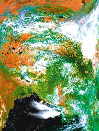
The first color composite image of Fengyun-2 H star.
(Profile picture)
The first color composite image of FY-3A.
(Profile picture)
"Stand high and see far", the meteorological satellites in the vast universe are like watchers of the earth's homeland, monitoring weather and environmental changes 24 hours a day; from the start of the meteorological satellite development mission in 1970 to the successful launch of 17 Fengyuns today Series of meteorological satellites.
Spanning 50 years, my country's meteorological satellite business has achieved a leap from scratch, from small to large, and from weak to strong.
The Fengyun series of meteorological satellites has successfully launched 17 meteorological satellites since the start of the meteorological satellite development mission in 1970, and 7 of them are in orbit, making great contributions to the cause of my country's meteorological satellites.
Why do we send so many satellites?
Why does this person's prosperous "family" make outstanding contributions?
A few days ago, a reporter from the Economic Daily interviewed Yang Jun, director of the National Satellite Meteorological Center and chief designer of Fengyun Meteorological Satellite Project, Dong Yaohai, chief designer of Fengyun 4 satellite system, and Tang Shihao, deputy chief designer of Fengyun Meteorological Satellite Project, to listen to the situation in their eyes. satellite.
"Competitive Star": Dare to dream and innovate
What kind of star is Fengyun Satellite?
In Yang Jun's view, there are three main definitions: it is a "people star" who knows cold and hot.
When people watch the weather forecast, Fengyun Satellite has a credit.
It is an independent innovation "competitive star".
Over the past 50 years, the strength of China's meteorological satellites has competed with developed countries in Europe and the United States, and some technologies have surpassed. Fengyun Satellite is one of them.
It is also a "Chinese Star" serving the world.
Since the birth of meteorological satellites, it has assumed the mission of disaster prevention, mitigation and relief.
In 1969, a rare rain, snow and freezing disaster swept half of China.
At that time, only two countries in the world had meteorological satellites, and the development of my country's meteorological satellites was imminent.
"We must build our own weather satellite!" In February 1970, the task of developing a weather satellite was issued and the Central Meteorological Administration approved the establishment of the "Meteorological Satellite Ground Station" (National Satellite Meteorological Center).
Seven years later, my country's first-generation polar-orbiting meteorological satellite was named "Fengyun No. 1", officially opening the era of storms.
After 50 years of tortuous exploration, Fengyun Satellite's growth has not been smooth sailing.
Dong Yaohai admitted frankly that they also "paid tuition."
The Fengyun-1A star had only worked in space for 39 days, and it "died prematurely" due to the loss of satellite attitude.
After three generations of hard work, Fengyun Satellite's "physical fitness" has been greatly improved.
The FY-1 C star has a lifespan of 7 years; the FY-2 F star has a design life of 4 years and has been in orbit for 8 years.
Looking back, Yang Jun said: "In the past 50 years, we have not fallen in every process of satellite development, and we have encountered every problem. Once these hurdles are passed, it means that we have mastered the core key technology."
In addition to the extended lifespan, satellite observation capabilities have also been greatly improved.
The China Meteorological Administration has mastered all core technologies through independent innovation. For example, the Fengyun-4 satellite, as the second-generation geostationary orbit meteorological satellite, is equipped with an interferometric atmospheric vertical sounder independently developed by my country, which can achieve high-frequency vertical detection once every 15 minutes at most. The detection range is expanded, and the time for acquiring three-dimensional data of atmospheric temperature and humidity is greatly reduced.
"This is our unique technology. With it, we can do'CT' for the atmosphere. Next, we will further solve the problem of higher-precision detection and make the weather forecast more accurate." Dong Yaohai said.
"People Star": Persist in serving the people
Since June this year, continuous heavy rainfall in the south has caused severe flooding in some river basins.
Among them, the average precipitation in the Yangtze River Basin is 50% more than normal in the same period, which is the highest in history since 1961.
At this time, Fengyun Satellite closely followed the growth and decline of the key lake area, and through the comparative analysis of satellite monitoring data for many years, it provided a scientific and reliable basis for the decision-making department for emergency rescue and disaster relief.
"Intuitively speaking, meteorological satellite monitoring first supports weather forecasts and accurately predicts the precipitation process during the flood season. Not only that, it also monitors and evaluates various meteorological disasters that may be caused after precipitation, and uses long-term satellite remote sensing monitoring data to comprehensively evaluate , To help government departments make decisions." Yang Jun said.
Especially in typhoon monitoring, Fengyun Satellite plays an irreplaceable role.
Since the Fengyun-2 satellite was put into operation to the end of August this year, none of the 566 typhoons generated in the Western Pacific and 165 typhoons landed in my country have been monitored.
After the Fengyun-4 satellite was put into operation, the timeliness for monitoring and identifying disasters such as typhoons and heavy rains in my country has been increased from 15 minutes to 5 minutes, the accuracy rate of early warning of sunny and rainy weather has increased to 89%, and the average error of 24-hour typhoon path forecasting has been reduced from 95 kilometers to 71 Km, better than the United States, Japan and other countries.
A good weather satellite not only takes pictures, but the most important thing is to make absolute quantitative measurements.
"What are the current and historical conditions of typhoons? With the addition of Fengyun satellites, comprehensive observational information from the atmosphere to space weather can be improved, so that every move on the sea can be monitored, and the accuracy of typhoon path and intensity forecasts has been improved year after year. Gradually reduce the loss of meteorological disasters to the minimum." Tang Shihao told reporters that the accuracy of numerical weather prediction is directly proportional to the increase in the quality and quantity of satellite data.
Now that the 7 stars are in the sky, what are they doing in the vast galaxy?
The answer is to set up a comprehensive observation constellation to realize the globalization and refined detection capabilities of the atmosphere and the earth's multi-sphere system.
Among them, polar-orbiting satellites fly across the equator around the north and south poles, and are mainly used for weather forecasting, ecology, environmental monitoring, and climate change research; geostationary satellites operate over the earth’s equator and operate synchronously with the earth’s rotation to carry out high-frequency observations of local areas. An expert in capturing mesoscale convective weather.
"The biggest feature of meteorological observation is that it works continuously 24 hours a day. Because the weather changes rapidly and is ubiquitous, satellites have to assume the role of the'guardian of the earth'. In the future, such a three-dimensional observation network will become denser and the level of data connection will be higher. High, stronger ability to capture various disasters to provide more accurate weather forecasts.” Yang Jun said that meteorological satellites should play the role of the first line of defense for disaster prevention and mitigation, and through multi-satellite coordination, disasters can be detected at the first time and the entire process recorded. .
In recent years, upgraded meteorological satellites have been integrated with new technologies such as cloud computing and big data to keep abreast of weather and climate fluctuations, continue to improve the accuracy of weather forecasts and the "smart" content of scientific research and judgment on weather trends, and keep closer to everyone.
Precision poverty alleviation and ecological construction are one of the fulcrums of meteorological services, and refined satellite data products and services cover all walks of life.
"China Star": Demonstrate the responsibility of a major country
Orange is sunny, gray is cloudy, and blue is rain... On the weather forecast service website for major cities related to my country's “Belt and Road” that was launched this year, these different color blocks are connected in series to outline a sheet covering 137 “Belt and Road”. A barometer of relevant countries and regions.
"As an important member of the Global Integrated Earth Observation System, the Fengyun Meteorological Satellite has been included in the World Meteorological Organization's Global Operational Application Meteorological Satellite Sequence. It is also a watch satellite for the International Charter Mechanism for Space and Major Disasters." Yang Jun said, countries that use Fengyun Meteorological Satellite data The number of regions and regions has increased to 115, including 65 "One Belt, One Road" countries, and provides data and products to more than 2,700 domestic users-Fengyun Satellite's global application service potential is gradually being released.
Mozambique is located in southern Africa and has frequent meteorological disasters such as tropical cyclones.
Last year, the country launched the Fengyun satellite international user disaster prevention and mitigation emergency guarantee mechanism three times, requesting the China Meteorological Administration to provide Fengyun satellite data products in the region.
On January 2 this year, local time, the delivery ceremony of the China Fengyun-2 meteorological satellite receiving, processing and application system aided by the China Meteorological Administration was held at the Mozambique National Meteorological Administration.
Mozambique has become the first country in Africa to apply this system, which has well filled the space-based monitoring vacancy, and received 24-hour continuous uninterrupted weather satellite monitoring services, and its weather forecast, disaster prevention and mitigation capabilities will be effectively improved.
At present, the signal reception of the system is good, operation and data storage are normal.
The international service achievements undertaken by Fengyun Satellite are far more than this.
From wildfires in New South Wales, Australia, to floods in southern Iran, from desert locust plagues in Pakistan to cyclones in the Bay of Bengal...Fengyun satellite disaster remote sensing monitoring demonstrates the responsibility of major powers.
From January 2019 to August 2020, my country produced and released 61 special reports on “One Belt One Road” remote sensing applications, providing remote sensing monitoring of typhoons, forest fires, sandstorms, floods, etc., for many countries and regions in Africa, Asia, and South America. service.
With advanced technology, stable business operations and high-quality data products, Fengyun Satellite is becoming the main force in the global Earth observation network together with the weather satellites of developed countries in the world, shouldering the global all-weather, three-dimensional, The responsibility of continuous observation has pushed Fengyun Satellite Meteorology business forward step by step.
Guo Jingyuan