
The maritime borders are one of the most complicated files in the relations between the countries of the Eastern Mediterranean, especially between Turkey and Greece, and with the succession of news and reports about the escalation of tension between the two countries in recent months, the exchange of accusations between Athens and Ankara, and the entry of many parties in this conflict.
It may be difficult for the observer to draw a map of the complexities of the maritime border file in the eastern Mediterranean, and in the Aegean Sea separating Greece and Turkey.
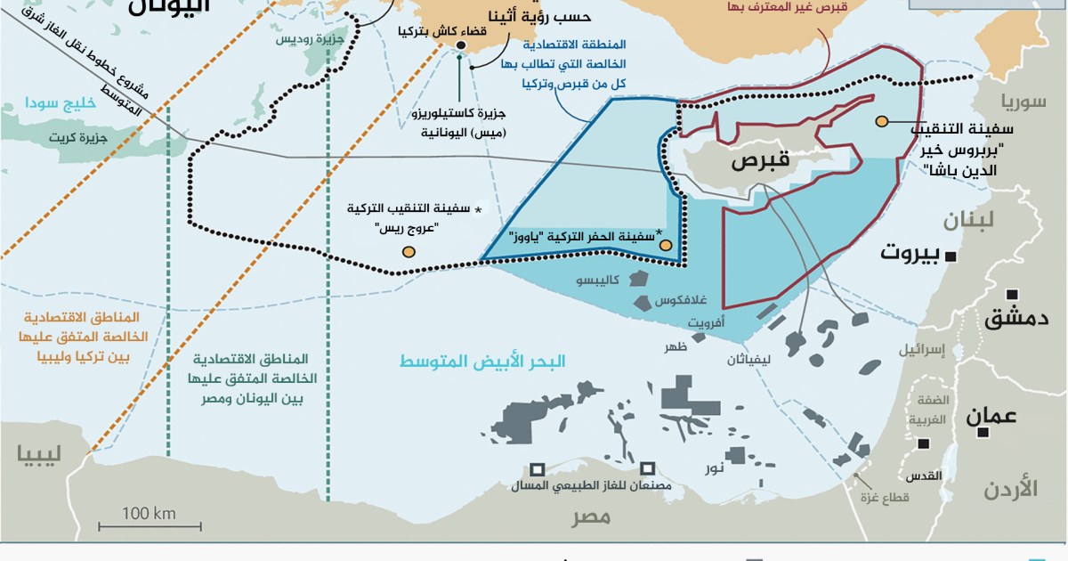
In order to help understanding, Al-Jazeera Net publishes a map (click here to enlarge) produced by the British magazine The Economist and published in its report entitled "The dispute between Turkey and Greece fuels tension in the eastern Mediterranean."
For a better understanding of the map, it is necessary to define some basic terms:
The exclusive economic zone
extends the exclusive economic zone to 200 nautical miles (370 km) according to the 1982 Law of the Sea, which is an international agreement, whereby neighboring countries can exercise some powers, but without affecting the legal status of that zone, given that the exclusive economic zone does not Subject to the sovereignty of the coastal state.
The riparian state can establish artificial islands and facilities, in addition to benefiting from the bounties of those waters, but on the condition that it announces its projects to other countries and allows it to exercise the right of exploitation in fishing, scientific research and the preservation of living resources.
The continental shelf
is the natural extension of the land into the seas and oceans, and for any coastal state, the bottom and subsoil of the land of submerged spaces that extend beyond the territorial sea.
The coastal state has sovereign rights over its continental shelf and benefits from its non-living natural resources such as oil, gas and minerals.
Article 76 of the Law of the Sea of 1982 states, "The continental shelf of any coastal state includes the bottom and subsoil of the submerged areas that extend beyond its territorial sea (territorial waters) throughout the natural extension of that country's land territory up to the outer edge of the continental margin, or to a distance 200 nautical miles from the baselines from which the breadth of the territorial sea is measured if the outer edge of the continental margin does not extend to that distance.
In the event that the continental edge of the coastal state extends beyond 200 nautical miles, the treaty limits the distance of the continental shelf in this case to 350 miles (648 kilometers).
The territorial waters were
settled by the 1982 Jamaica Convention by clarifying that "every state has the right to limit the breadth of its territorial sea by a distance not exceeding 12 nautical miles (22 kilometers), starting from the baselines established in accordance with the provisions of this agreement."
Whereas, it is the right of every state to exercise its sovereignty over its territorial maritime domain, starting with policing, defining maritime ceremonies that maritime ships must follow, and organizing navigation and trade within it.
Sovereignty extends to the sea floor, where the state can benefit from and exploit what is included in the sea floor.
The 1982 agreement stipulated that the state's sovereignty extends to "the airspace above the territorial sea, as well as the floor of this sea and the layers below it."