
- Weather Check the forecast in your area
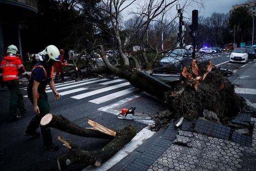
A total of 37 provinces will be this Friday at risk from wind, rain, avalanches, thawing and waves, with Cantabria, Guipúzcoa and Vizcaya in red warning for coastal phenomena, according to the prediction of the State Meteorology Agency (Aemet), which provides rainfall persistent in the Pyrenees, with significant snowfall at high levels, as well as very strong wind in the eastern Cantabrian and high levels of the Pyrenees.
In yellow risk by avalanches will be Huesca, Lleida and Navarra ; by rain, Huesca, Zaragoza , Lleida and Navarra; and by thawing, Huesca, León and Navarra.
By wind, the notice will be yellow in Granada, Jaén , Zaragoza, Cuenca, Guadalajara, Ávila, Burgos, Palencia, Segovia, Soria, Girona, Melilla, Alicante, Ibiza and Formentera, Mallorca, Asturias, La Rioja and Murcia ; which will rise to orange in Guipúzcoa, Vizcaya, Castellón , Valencia, Navarra, Madrid , Lleida, Tarragona , Lleida, Barcelona, León, Albacete, Cantabria , Huesca, Teruel and Almería .
Coastal phenomena will put Málaga , Girona, Barcelona, Tarragona, Valencian Community , Mallorca, Menorca, Ibiza and Formentera, and Murcia at risk; which will rise to orange in Asturias, A Coruña, Lugo, Pontevedra , Melilla, Almería and Granada; and it will be red in Cantabria, Guipúzcoa and Vizcaya.
The skies will be cloudy or covered with rains in the northern peninsular third, moderate and persistent in the Pyrenees and tending to cease throughout the day in the Cantabrian. In the rest of the Atlantic slope, they will be initially cloudy or overcast, with rains in mountain areas, opening clear and remitting rainfall throughout the day.
In the Mediterranean area only medium and high cloud intervals are expected, while in the Canary Islands there will be cloudy intervals in the north and slightly cloudy or clear in the south.
The snow level in the Pyrenees will be at 1,800 meters up to 2,200 meters. In the case of temperatures, they rise in the Peninsula and the Balearic Islands , especially the lows in the interior of the southern half, which do so notably; and in the Canary Islands they fall slightly.
There will be weak frosts only in high levels of the Pyrenees and west wind in the Peninsula and Balearic Islands, very strong in the eastern Cantabrian and high levels of the Pyrenees and strong or with intervals of strong in Asturias and northern Galicia, Central and Iberian systems, rest from the eastern peninsular third, the Balearic Islands and the Andalusian Mediterranean coast. They will be trade winds in the Canary Islands, occasionally strong at first in the western islands.
According to the criteria of The Trust Project
Know more- Navarre
- Canary Islands
- Cantabria
- Balearics
- Guipúzcoa
- Asturias
- Biscay
- Valencian Community
- The Rioja
- Galicia
Meteorology The worst storm of autumn comes with 37 provinces warned by snow, wind, waves or rain
Meteorology A deep storm brings warnings to 39 provinces, especially by rain, wind or bad sea
BANCABanco Santander completes the ERE with 3,030 voluntary adhesions