
- Albania earthquake: new strong shock 5.6 near Tirana, rescue operations suspended
Share
November 27, 2019The 85 November earthquake in Albania was triggered by an 85-kilometer fault that extends from the North-West and South-East between the cities of Durres and Lushnje and has not been fully activated.
It emerges from the analyzes of the National Institute of Geophysics and Volcanology (Ingv). The fault "belongs to the structures responsible for the deformation and overlapping of the sediments that constitute the nucleus of the Albanidi chain". It is believed that a similar fault has caused, in Albania, the magnitude 5.8 earthquake of 21 September.
According to seismologists the effects of the earthquake "could have been amplified by the geological conditions of the region". In fact, here there are basins of unconsolidated sediments, in which the amplitude of the seismic waves can increase even 4 or 5 times compared to that which would occur in a rocky and consolidated soil. The aftershocks after the main one, whose magnitude was recalculated in 6.2, are currently at least 70. Of these there were about 50 of magnitude between 3 and 4, ten of magnitude between 4 and 5 and remain at the three recorded magnitudes yesterday those with a magnitude greater than 5. In addition, the magnitude 5.3 earthquake occurred yesterday in Bosnia and Herzegovina and the magnitude 6 earthquake with its epicenter not far from the island of Crete (Greece) occurred at 8:23 today.
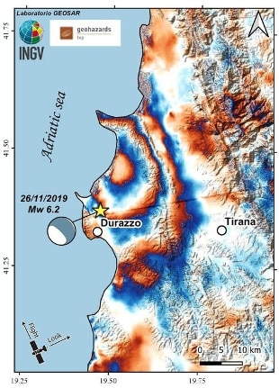
The soil near Durazzo is raised by 10 cm
He raised the ground by about 10 centimeters near the city of Durres, the 6.2 magnitude earthquake that occurred yesterday along the coast of Albania. This is shown by the radar images taken by the Sentinel-1 satellites of the European Copernicus program of the European Space Agency (ESA) and the European Commission, analyzed by the seismologists of the National Institute of Geophysics and Volcanology (Ingv). Synthetic aperture radar (Sar) allowed to measure the deformation of the soil, as happened for the 2009 earthquakes in L'Aquila, 2012 in Emilia Romagna and 2013 in Lunigiana. The deformation was measured by the Geohazard-tep online platform, developed by ESA, using a pair of radar images acquired from Sentinel-1 satellites from the same location, before and after the earthquake. The comparison between the two images made it possible to obtain an interferogram, ie the map of the displacement of the soil. This was also obtained on the basis of the electromagnetic signal emitted by the satellite, reflected from the earth's surface and captured by the sensor, which is represented in the image obtained with different color cycles. Each cycle (or fringe) represents a shift of the earth's surface along the line of sight of the half-wavelength satellite of the emitted signal.