
- Meteorology.'Veroño 'in almost all of Spain, with sun and more than 30 degrees in some areas
- 'Veroño' of 2017. Temperatures 11 degrees above average
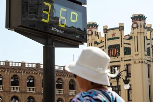
The almost summery weather of the first weeks of autumn, a period that is sometimes known as veroño , will stay this week in large areas of Spain because the sun will shine in many places . Daytime temperatures will be between 5 and 10 degrees higher than normal in more than half a country and the rains will be weakly restricted to the northern tip of the peninsula and perhaps the Balearic Islands.
One of the spokesmen of the State Meteorological Agency (Aemet), Rubén del Campo, said that this week's weather will be "quiet" and no major changes are expected, except that on Wednesday the temperatures in the northern peninsular will drop sharply. arrival of winds from the north, but the thermometers will pick up later and the heat will settle this weekend entirely festive, since Saturday will be the National Holiday Day.
"In general, this week's temperatures will be high for the time of the year and little rain is expected, except in the peninsular north end and some in Catalonia and the Balearic Islands," he added.
Del Campo commented that in these anticyclonic and stable days there will be two phenomena characteristic of this era: the morning fogs in areas of the peninsular interior, especially in the North Plateau, and an important thermal amplitude. This is the temperature difference between day and night.
The thermal amplitude will approach 15 degrees in much of the country , will be around 20 degrees on the North Plateau and even punctually it will be 24 degrees. For example, Cuéllar (Segovia) will have a minimum temperature of 5ºC at dawn on Tuesday and will reach 29ºC during the day, while Palencia will have 9ºC at dawn and 29ºC during the day.
This is due to the combination of clear skies and longer and longer nights, since the daytime heat escapes into the atmosphere and cools the surface. "It is typical of early fall and spring," Del Campo said.
On the other hand, Del Campo said that on Tuesday a less active Atlantic front will approach Galicia that will leave rains in the north of that region, the Cantabrian communities, the north of Castile and León, and the upper Ebro. There will be morning fog banks in the Mediterranean area and it will blow up in the Strait area. In the rest of the country the sky will be almost clear.
The temperatures of this Tuesday will rise in the Ebro, the eastern Cantabrian and the Pyrenees, and will descend in the coastal provinces of Andalusia. "They will be high for the time, with 28 to 30 degrees in many areas of the northern peninsular half, about 30 in the south of the Community of Madrid and 34 or even 35 in the valleys of Guadiana and Guadalquivir. They will be between 5 and 10 degrees above normal in almost all of Spain, "he said.
According to the criteria of The Trust Project
Know more- Spain
Spain The cold drop remains stationary but more weakened in the peninsular west half
Weather 'Veroño' in almost all of Spain, with sun and more than 30 degrees in some areas
Cold drop Pedro Sánchez in Orihuela, to the neighbors affected by the storm: "We will be here"