
Monday hot weather will extend throughout the Hexagon, except Brittany, according to Météo-France, which has already Sunday Sunday Paris and its small crown (75, 92, 93, 94) and the Seine-et-Marne, vigilance orange for heat wave.
From the South-West to the Belgian border, the day promises to be hot under a hazy sky. To note anyway in the morning a few grisailles on the south of Aquitaine and ripples passing on the Poitou-Charentes. In the morning, rains passing momentarily and sometimes mixed with a thunderclap will cross the Pays de la Loire, Brittany and Lower Normandy. During the day, showers will remain frequent in Brittany. They will extend to all Normandy and at times to the Pas-de-Calais. In the evening, they will become more sustained and stormy, with a risk of gusts and hail, especially on Basse-Normandie.
Gusts of wind that will reach 80 km / h in the Tarn
From the North-East to the Mediterranean regions, except for some low clouds quickly dissipated on the edge of the Gulf of Lion, the sky will be very sunny. The wind of autan will strengthen in its field, to reach up to 70/80 km / h on the Lauragais and the relief of the Tarn. The south wind will also blow quite hard on the relief of the Pyrenees.
Up to 37 degrees in Auvergne
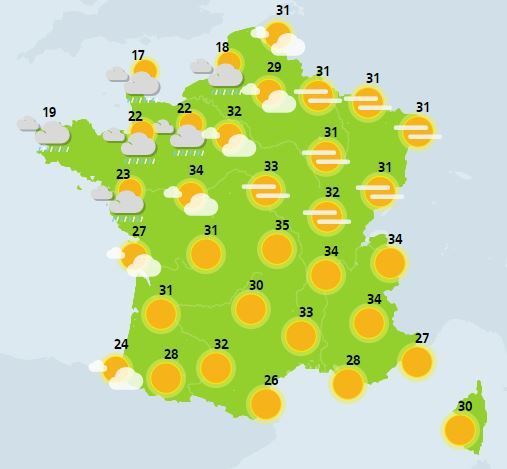
Monday morning, it will be between 14 and 20 degrees in general. In the afternoon, the maximum will not exceed 19 to 25 degrees on Brittany and Cotentin. However, they will climb between 27 and 32 degrees in the land in Aquitaine, Poitou-Charentes and Pays de la Loire in the Hauts de France, locally up to 33 in Paris. In the rest of the country, it will take 31 to 34 degrees, locally 35 to 37 in the valleys of Auvergne and Rhône-Alpes in the Provencal hinterland.
>> Here is the weather map for Monday:
Weather Map-France.