
Dubai Municipality is participating in GITEX 2018 to enhance its position at the local, regional and global levels and share experiences with the participants in this prestigious global event, which is being attended by many international companies and institutions.
The municipal platform at GITEX contains several projects and systems that reflect the activities of the department and its efforts by presenting the experience of the most advanced technologies in the world, and the payment of digital transformation, in addition to future projects in Dubai, and smart cities that The next generation technologies are used in the infrastructure. They also presented a series of films about their efforts in the development process and the provision of services to the community, and the modern systems followed by the department in various fields.
One of the projects involved is the Rescue Bird Project, a project aimed at maintaining the safety and safety of public beach users in the emirate through an unmanned aerial vehicle whose unique design is capable of responding to individual or collective drowning by transporting up to four lifter buoys Which can support as many as eight drowned at once and can be used with a raft.
The exhibition also included the design of GEO Dubai, the first project of its kind in the region, an initiative to organize and facilitate geo-engineering procedures in the Emirate of Dubai, where planning maps will be created and approved in the municipality for future areas. Infrastructure, and an updated baseline map based on engineering needs that aim to make quick decisions, contribute to emergency response, and sustain smart city, to the well-being of the individual and society.
The Dubai Municipality platform also included the Smart Map of Dubai Smart Zone, the first interactive map to be displayed on a smart, transparent and interactive screen in the Middle East. It will be distributed directly to Dubai to help make Dubai a smart and sustainable city. Community in the Emirate of Dubai, to facilitate the process of roaming in the Emirate, and contains information about the area in which it was installed such as events near the area, points of interest, place numbers and other information.
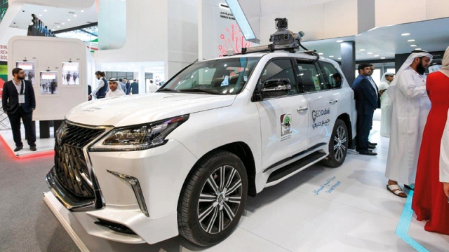
The exhibition also included the Geomagnetic Survey Vehicle, an integrated solution for collecting geospatial information on the roof of the car, to prepare three-dimensional maps, consisting of a high-precision laser scanner, GPS devices, For 360-degree photography. The use of the system greatly improves the accuracy, speed and safety of data collection on highways and congested roads. The municipality is the first government department in Dubai to own such a vehicle.
The Municipality also presented a three-dimensional aerial survey project, in which the unmanned aerial vehicle is used to conduct accurate aerial photography, with the aim of creating accurate maps of the areas, installations and projects, for immediate and continuous updating of the comprehensive and unified base map for Dubai.
The project was attended by all the government and private entities in Dubai for quick access and delivery of services. Of the population, in addition to linking and integrating transactions and services.
Smart Roaming
The Dubai Municipality platform has incorporated the Intelligent Roaming Project, a technology-based application to locate the user within Dubai's public buildings, allowing users to roam around the building, and easily access the commercial or residential unit by providing the user with direct navigation.