
The pandemic has forced many to look for different leisure alternatives, and walking tours in nature have been the ones that have taken the first prize.
Thousands of citizens have discovered a new way of
traveling
and discovering the world through the kilometers and kilometers of roads that flood our geography.
There are routes of all kinds and anywhere, and almost all of them have been covered by Sergi Ramis, an expert cyclist and hiker.
The also journalist and travel and hiking writer has just published
Spain on foot
(Geoplaneta editorial), a guide with illustrated maps and photographs that brings together 40 historical hiking routes, many of them practically unknown.
From mountains, through forests, across plains, along the coast, climbing peaks ... the variety is enormous.
From the hand of Ramis, we selected
four routes
to discover this summer.
By paradisiacal beaches
The
Maritime-Terrestrial Natural Park of Cabo de Gata-Níjar
(Almería) surprises for its diversity of landscapes: mountains, deserts, paradisiacal beaches ... The fact that almost most of it is unbuilt, makes it possible that the connection with the nature while walking its trails is total.
In this case, most of the route is along the coastline and you can enjoy extraordinary ones, such as the Genoveses or the Media Luna cove.
Playa de los Genoveses (Almería).
The
route is circular, 13.2 km
and begins and ends in a parking lot on the outskirts of the town of San José. To complete it, you have to dedicate at least five hours (that is if you do not decide to bathe). It is suitable for everyone, easy, but it has stony slopes and some sections on cliffs. It is recommended to wear hiking boots, even when crossing some sandy areas, and, of course, a lot of water (it is a desert environment). The itinerary, signposted, begins along the coast. After leaving the car park, the path heads to Playa de los Genoveses (leaving the Collado de los Genoveses mill on the left). Once you have skirted the beach, you arrive (3.2 km later) at Morrón de los Genoveses, a viewpoint that encompasses the town of San José and the cove of Los Amarillos in the foreground.From there it joins the Príncipe cove (with sections on vertical cliffs) and further on with Cala Grande (km 5), Cala del Lance (km 5.6), Barronal beach (km 6.5), the cove de Mónsul (km 7.3) and, finally, with the beautiful cove of Media Luna (km 8), on a path equipped with wooden fences.
From there, you return to the starting point along a path through the interior (formally it is the ALP-901 road, which has almost no circulation).
The route arrives again at the Genoveses beach, next to the mill.
And from there, you return to the parking lot in the same place.
During the excursion you will be able to see pitas and prickly pears, some ocellated lizard or sleepy snake.
Between castles
The route of the Birth of the Cerezuelo river, in which the castles are the protagonists, runs through the heart
of the Natural Park of the Sierras de Cazorla, Segura and Las Villas (Jaén)
.
It is circular, 8.1 km long, easy and goes along a well-conditioned path, with walkways and wooden railings in many sections, so it can be done as a family.
It begins and ends in the town of Cazorla, south of the Yedra castle, next to the parking lot, and it takes about three and a quarter hours to complete.
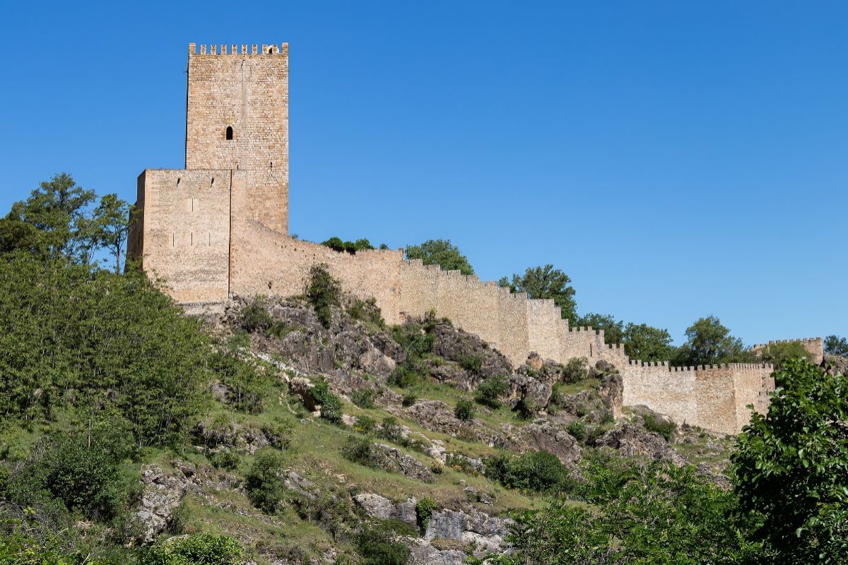
Yedra Castle.
The itinerary (Cerezuelo trail) begins at the confluence of Hoz Alta and Camino del Ángel streets, and runs along the Cazorla river, at least the first part, an opportunity to see waterfalls, pools where it is allowed the bath, bridges, viewpoints ... At kilometer 1.8 you reach Nacelrío, a source where it is officially considered that the Cerezuelo route begins. At km 3.6 begins a succession of viewpoints (three) that offer beautiful views of Cazorla and the surroundings. The road continues its course to the starting point, not without first passing through the hermitage of the Virgen de la Cabeza, the charming town of La Hiruela, with its castle, the Palacio de las Cadenas, already close to Cazorla, and, finally, Yedra Castle, a fortress on a hill from the 12th-15th centuries with the best views of the natural park.
Through magical forests full of legends
Between the Galician towns of Triacastela and Sarria, is
the corredoira de Samo
, a variant of the Camino de Santiago as it passes through that province. It is a narrow country road, escorted by stone walls full of mosses and lichens and surrounded by forests of huge chestnut trees that transport the walker to a magical world. The route, linear, begins in Triacastela, next to the public pilgrim hostel, and follows the LU-633 road until it ends in the town of Sarria, one of the most important on the Camino in Galicia (there is a bus to return to the starting point) . Along the 24.4 km that separate the two towns (follow the arrows that indicate "Por Samos"), you pass through small villages (San Cristovo do Real, Renche, Lastre, Freituxe and San Martiño do Real) , lush forests and the monastery of San Julián de Samos, an authentic architectural and historical gem,formed by a set of buildings founded by the Benedictine order in the s. SAW. Many call it El Escorial Gallego. Once through the town of Aguiada (km 20.2), the landscape changes to pastures for livestock and crops, before reaching Sarria (km 24).
Sarria forests.
Between lakes at 2,000 meters of altitude
The
route of the Roya Canal and the Anayet lakes
, in the Aragonese Pyrenees, offers one of the most spectacular landscapes in the Pyrenees at more than 2,000 meters of altitude, including the panoramic view of the emblematic French peak Midi d'Ossau.
It is linear (there and back along the same path), 18.6 km long and of moderate difficulty, due to the marked unevenness of the path, which is marked by paint and beacons.
It is always recommended to check the weather forecast beforehand.
The route, which traces the same huge curve as the Canal Roya river to go up to the Anayet lakes (lakes of glacial origin), starts at the Canal Roya car park, at the foot of the N-330a road. Next, the remains of the Anglasé foundry, an iron ore exploitation in the area in the 18th century, and the source of the Cherry tree appear. The path that runs near the right bank of the river (you have to cross it at a certain point) finally opens up to a wide green U-shaped glacial valley, where you will find a shelter, useful in case of emergency, and little little by little it progressively ascends until it reaches a group of lakes. The area known as Mal Paso, a narrowing where the river is confined, and the Llano de la Rinconada, the area where the glacial valley and the meanders described by the river are best appreciated,are other of the points of the route.
Ibones del Anayet (Huesca).
Following a very steep zigzag path, the Anayet lakes finally appear (km 9.5), from where you can see perfectly the silhouette of the Midi d'Ossau peak (in the French Pyrenees, 2,884 m), with its gallows appearance and of black stone.
After a rest and recharge by eating something, you have to go back.
The duration can exceed six hours, depending on the fitness of the hiker.
According to the criteria of The Trust Project
Know more
PlansFive towns designed to disconnect
AgendaEight cultural proposals to close the month of May
These are the best destinations in Spain to play golf
See links of interest
Work calendar
Home THE WORLD TODAY
Best Universities
Sergio Ramos
Ukraine - North Macedonia, live
Denmark - Belgium, live
Belarus - Spain, live
Netherlands - Austria, live