
- Photos of bad weather, red alert in Genoa. Floods in Piedmont
- Rains and thunderstorms in the center-north. Red alert in Liguria and part of Piedmont
- New wave of bad weather over the weekend: thunderstorms and strong winds over most of the country
- Bad weather: alarm ceased for the Arno and other rivers in Tuscany. A train derails in Val Pusteria
- Bad weather: flooding, schools closed in the Alessandria area. Genoa: orange alert. Incoming cyclones
Share
November 23, 2019The bad weather continues to scourge Liguria and Piedmont above all where deterioration is expected. Red alert therefore prolonged in both regions and tomorrow also in Calabria. Under observation the rivers that in many areas are overflowed and also the coastal areas hit by intense storm surges.The experts of the Civil Protection Department speak of "further worsening of the weather conditions in the north-west regions of Italy, with intense and persistent rainfall that will continue until tomorrow."
Regions affected by red alert
"In the next few hours the bad weather phase will extend to the south-central, with intensification of the winds from the southern quadrants. For the whole day tomorrow, a flow of south-eastern currents will hit all the ionic sectors, associated with intense precipitations that will take on persistent character, especially in Calabria ". On the basis of the phenomena envisaged and underway, it has been evaluated for tomorrow, Sunday 24th, "red alert" in Calabria and in some sectors of Piedmont and Liguria.
The orange alert
Evaluated "orange alert" on the sectors of Piedmont and Veneto, on most of Emilia-Romagna, on the central-southern area of the Marche, on southern Lazio, on the coastal slope of Campania, in Puglia, on a large part of Basilicata and Sicilia. "Yellow alert", also in Valle d'Aosta, Trentino Alto Adige, Tuscany, Umbria, Abruzzo, Molise, on some sectors of Lombardy, on the southern area of Friuli Venezia Giulia, on the remaining territories of Piedmont, Veneto, Emilia- Romagna, Lazio, Campania, Basilicata, Puglia and Sicily.
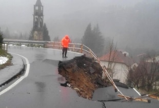
Overflowing rivers and landslides in Liguria
In Liguria floods and landslides have occurred. There is no peace for Valpolcevera in Genoa, already battered by the collapse of Ponte Morandi. Underwater, cellars and shops under water. There are 33 people displaced in the city, one in the Savona area and 600 isolated due to the prolonged red weather alert until tomorrow in the center-west of Liguria. Work on the new Polcevera viaduct is suspended. Governor Toti has urged citizens to "limit travel".
The situation worsens in Piedmont
The hydrogeological situation in Piedmont worsens, where the forecasts of the Functional Center of Arpa Piemonte indicate, due to the persistence of bad weather, the transition to the red alert in the areas of Val Sesia (in the Vercelli area), Cervo (Bi, Chiusella, Orco, Lanzo , low Val Susa and Sangone (To), Tanaro (Cn), Belbo (Al, At, Cn) and Bormida (Al). Orange alert throughout the rest of the region, with the exception of the Maira, Varaita and Stura Valleys, in the province of Cuneo, where a yellow alert is reported.
The Champorcher valley is isolated in the province of Aosta
The valley of Champorcher (Aosta) is isolated due to the fall of an avalanche on the regional road, near the town of Pontboset. "It's a flow of water mixed with snow, what worries us is what could still come down. That's why we closed the road with an ordinance," explains the mayor of Pontboset, Paolo Chanoux. "At the moment - he adds - the road cannot be traveled even in the event of emergencies"
Possible tidal peak in Venice
Ten days after the 'aqua granda' which on Tuesday 12th saw 187 centimeters, the second highest in history since it is known, in Venice the high water nightmare returns. The forecasts issued by the Tide Center of the Municipality of Venice in fact forecast for tomorrow at 8.50 am a possible tidal peak of 140 centimeters, well below the exceptional tide of last week but still sufficient to flood Piazza San Marco, the Basilica, the shops and much of the city.
The notice of the Civil Protection Department
The Department - in agreement with the regions involved - issued a further notice of adverse weather conditions that complements and extends the one released yesterday. As of today, Saturday 23 November, the warning includes "storm winds from the southern quadrants, with reinforcements up to strong storm on Sicily, in extension during the next night in Calabria, Basilicata and Puglia and, from tomorrow morning, Sunday 24 November, to the Adriatic sectors of Molise, Abruzzo and Marche Provided for swells along the exposed coasts, more intense on the Ionian sectors.From the evening of today we expect precipitations from scattered to widespread, even to reverse or temporal, on Sicily, in extension during the next night in Campania and Calabria and, from tomorrow morning, in Basilicata, Puglia, Molise, Abruzzo and Marche, assuming the character of persistence on the ionic sectors, where the quantities will be abundant. Precipitation will be accompanied by showers of strong intensity, frequent electrical activity and strong gusts of wind.From tomorrow afternoon, moreover, scattered precipitation will persist from merged, even with a reverse or strong storm, over Emilia-Romagna ".