
Yesterday, satellite imagery showed air pollution in urban areas across Europe slipping through closures to combat the spread of the Coronavirus, but activists warned that city dwellers were still most at risk from the pandemic.
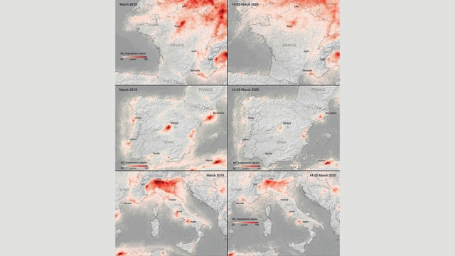
Satellite images «Sentinel-5» showed a decrease in the average levels of harmful nitrogen dioxide in cities, including Brussels, Paris, Madrid, Milan and Frankfurt in the period between the fifth and twenty-fifth of March, compared to the same period last year.
This coincides with the closure in many European countries that have restricted road transport, which is the largest source of nitrogen oxides, and slowed plant gas emissions.
The new images released by the European Space Agency and analyzed by the European Public Health Alliance, a non-profit organization, show a change in the density of nitrogen dioxide that can cause respiratory problems and cancer.
Data from the European Environment Agency showed a similar trend during the period from 16 to 22 March. The average levels of nitrogen dioxide in Madrid decreased by 56% on a weekly basis, after the government banned unnecessary travel.
The European Public Health Alliance said people who live in polluted cities may be at greater risk of contracting the Coronavirus (Covid-19).