
Researchers at the University of Tokyo analyzed satellite images of the damage and impact of flood damage caused by a dam failure in southern Ukraine, and found that the flood damage had spread to an area about 90 kilometers away.
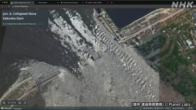
In Kherson Oblast in southern Ukraine, a large-scale flood occurred on the 6th when the dam of the Kahouka Hydroelectric Power Plant on the Dnipro River broke.
Professor Hidenori Watanabe of the University of Tokyo's Graduate School, who is analyzing the situation in Ukraine using satellite images, checked the satellite images taken on the 8th and found that the flood damage had spread to the mouth of the Dnipro River, about 90 km from the dam.
In the coastal area downstream of the dam, a wide area of villages and areas lined with apartment buildings has been submerged, and the color of the water has darkened over time, confirming that the depth has increased.
In addition, the water in the reservoir of the dam has dried up and part of the bottom can be seen, indicating that the water level has dropped sharply.
Furthermore, satellite images of the reservoir located upstream of the dam that supplies cooling water to the Zaporozhye Nuclear Power Plant show that the water level has decreased due to the increase in land area inside and around the reservoir compared to before the collapse.
Professor Watanabe said, "Many villages and towns are submerged downstream of the dam, making it extremely difficult to rescue and rebuild the town. Risks are increasing on a national and global scale, and an end to the war is required as soon as possible."