
This article is a monthly summary, while the most interesting weather events can be found in my analysis of the May weather.
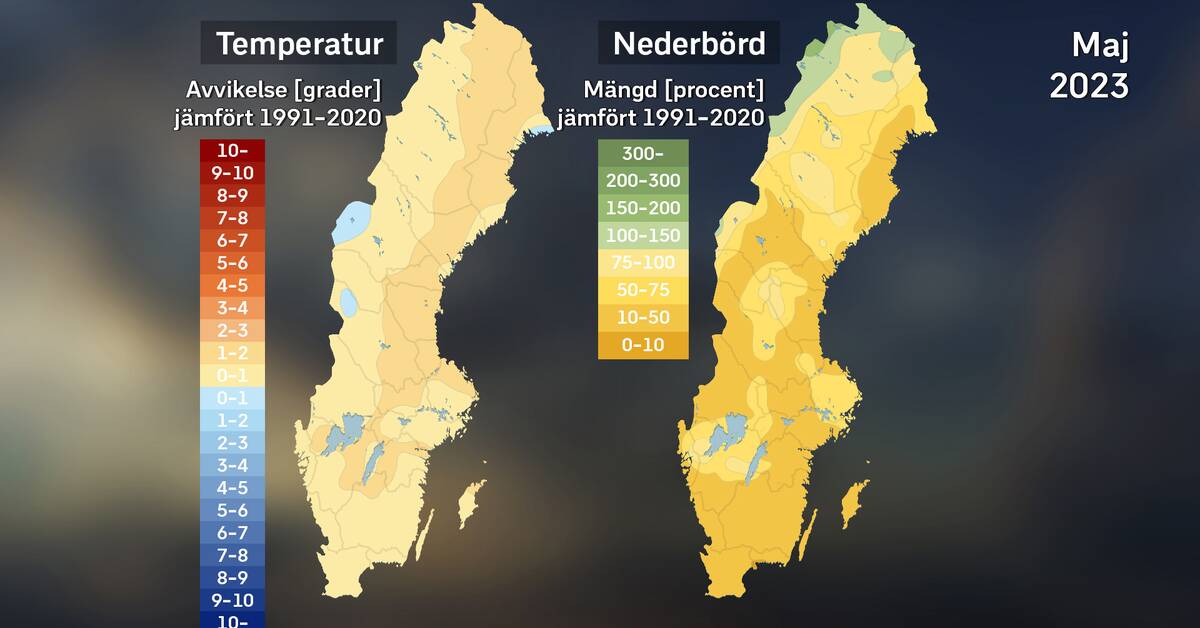
The heat predominated
A chilly start week, then just over a week's heat followed by cooler for a few days, then warm again before a cool finish, which, however, managed to turn into warm again in the south. So it has probably fluctuated a lot, which in terms of the reference years 1991–2020 gives an average temperature close to or above normal, around 2 degrees at most.
Compared to the previous reference period 1961–1990, the deviation is of course greater than that in most of the country, which is of course due to the ongoing climate change. What is normal weather in May, and how it has changed, can be read about in normal weather in May.
On the left, the average temperature of the month compared to the reference period 1991 to 2020. To the right, the month's highest and lowest monthly average temperature and the extremes regarding deviation from normal monthly average temperature. Sources: SMHI and StormGeo. Photo: SVT
In recent years, cold May months have been the most common, so for almost the entire country, it is enough to go back to last year, 2022 that is, to find a colder May than this year's. It was warmer than this year, mainly in 2018, a May that was extremely hot.
Dry – drier – but not driest
The dry weather dominated, so overall May was a dry to very dry month in almost the whole country, mainly parts of Lapland excepted. Driest in the southeast, where locally it has come about a tenth of normal. No wonder the risk of forest fires in forests and fields has increased.
On the left, the month's precipitation amounts in percent compared to the reference period 1991 to 2020. To the right, the month's highest and lowest precipitation amounts, both in percentage and millimeter counted. Sources: SMHI and StormGeo. Photo: SVT
The May records for little precipitation are largely close to 0 mm, so despite a dry month, no longer measurement series set new dry records for May. Among other things, it saw the setback on 16-17. Locally, however, it was one of the driest May months on record, for example in Osby, Skåne, which at 5.5 mm had the second driest since records began in 1931. Their record is 0.5 mm from 1978, and normally Osby gets 57 mm in May.
We last had just as widespread with little rainfall in May in 2018, but then with even worse drought because it was warmer and sunnier. Last year, 2022, although May was partly dry, it was still wetter than this year in almost the whole country.
Plenty of sun, except in Östersund
The sun shone very frequently in May. However, there is a clear exception, because in Östersund, Jämtland you got clearly less sun than usual. In parts of the country, this year's May became the second sunniest after extreme May 2018. Karlskrona, Blekinge (starting year 2009) set a new sunshine record for May with 397 hours compared to the previous 389 hours in 2018.
On the left, the average gusty wind in the month as a percentage of normal during the period 1996–2015. To the right, the month's highest average wind for mountain stations, highest average wind for coastal stations and highest gusty wind for inland stations. Sources: SMHI and Photo: SVT
May offered two storms in Stekenjokk in the southern Lapland mountains, first in the afternoon of the 24th, then at midnight on 30–31. On average, about normal wind gusts, with mostly slightly windier than normal in the north and slightly less windy than usual in the south.
External sources: StormGeo, SMHI and social and other media