On Sunday the anticyclone Lucifer will give the best of itself reaching the peak of heat. Also on Sunday, apart from some afternoon thunderstorms expected over the Alps, the sun and the African heat will be the protagonists of the day. The first will shine almost undisturbed, the second will reach peaks of 37 C on the inland areas of Sardinia and up to 34-36 C on Tuscany, Lazio, Emilia, Marche, Veneto, Lombardy, Puglia and Basilicata. The presence of the anticyclone will be short-lived, in fact as early as Monday cooler air will gradually begin to flow from the north-eastern quadrants which will be responsible for the destabilization of the anticyclonic structure. Thunderstorms will affect the Northeast regions (especially theEmilia Romagna and Friuli Venezia Giulia) and eastern Lombardy and then descend to the Center reaching Marche and Umbria. In the following days, the cooler air will cause a marked drop in temperature over most of the regions while thunderstorms will drop along the entire Adriatic belt. Saturday 21 In the north: sun and heat. In the center: ample sunshine. South: partly cloudy sky. Sunday 22 In the north: afternoon thunderstorms in the Alps, sun and heat elsewhere. In the center: prevailing sun. In the south: ample sunshine. Monday 23 In the north: thunderstorms in the Triveneto Alps, lower Veneto and Emilia Romagna. Center: worsens with thunderstorms over Marche and Umbria. South: sunny. From Tuesday thunderstorms over the Adriatic regions. (source: meteo.it, Agi)cooler air will cause a marked drop in temperature over most of the regions while thunderstorms will drop along the entire Adriatic belt. Saturday 21 In the north: sun and heat. In the center: ample sunshine. South: partly cloudy sky. Sunday 22 In the north: afternoon thunderstorms in the Alps, sun and heat elsewhere. In the center: prevailing sun. In the south: ample sunshine. Monday 23 In the north: thunderstorms in the Triveneto Alps, lower Veneto and Emilia Romagna. Center: worsens with thunderstorms over Marche and Umbria. South: sunny. From Tuesday thunderstorms over the Adriatic regions. (source: meteo.it, Agi)cooler air will cause a marked drop in temperature over most of the regions while thunderstorms will drop along the entire Adriatic belt. Saturday 21 In the north: sun and heat. In the center: ample sunshine. South: partly cloudy sky. Sunday 22 In the north: afternoon thunderstorms in the Alps, sun and heat elsewhere. In the center: prevailing sun. In the south: ample sunshine. Monday 23 In the north: thunderstorms in the Triveneto Alps, lower Veneto and Emilia Romagna. Center: worsens with thunderstorms over Marche and Umbria. South: sunny. From Tuesday thunderstorms over the Adriatic regions. (source: meteo.it, Agi)afternoon thunderstorms in the Alps, sun and heat elsewhere. In the center: prevailing sun. In the south: ample sunshine. Monday 23 In the north: thunderstorms in the Triveneto Alps, lower Veneto and Emilia Romagna. Center: worsens with thunderstorms over Marche and Umbria. South: sunny. From Tuesday thunderstorms over the Adriatic regions. (source: meteo.it, Agi)afternoon thunderstorms in the Alps, sun and heat elsewhere. In the center: prevailing sun. In the south: ample sunshine. Monday 23 In the north: thunderstorms in the Triveneto Alps, lower Veneto and Emilia Romagna. Center: worsens with thunderstorms over Marche and Umbria. South: sunny. From Tuesday thunderstorms over the Adriatic regions. (source: meteo.it, Agi)
Bad weather: landslide in Sonico nel Bresciano, cars involved
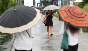
The heat gives way to bad weather, yellow alert in four regions
Bad weather in the North: Lake Como overflows, look at the bridges over the Adige
Bad weather, Lecco: 120 people evacuated from camping, landslide on provincial road
Share
August 21, 2021On Sunday, the anticyclone Lucifer will give the best of itself reaching the peak of heat.
Also on Sunday, apart from some afternoon thunderstorms expected over the Alps, the sun and the African heat will be the protagonists of the day.
The first will shine almost undisturbed, the second will reach peaks of 37 C on the inland areas of Sardinia and up to 34-36 C on Tuscany, Lazio, Emilia, Marche, Veneto, Lombardy, Puglia and Basilicata.
The presence of the anticyclone will be short-lived, in fact as early as Monday cooler air will gradually begin to flow from the north-eastern quadrants which will be responsible for the destabilization of the anticyclonic structure. Thunderstorms will affect the northeastern regions (especially Emilia Romagna and Friuli Venezia Giulia) and eastern Lombardy and then descend to the Center reaching Marche and Umbria. In the following days, the cooler air will cause a marked drop in temperature over most of the regions while thunderstorms will drop along the entire Adriatic belt.
Saturday 21
In the north: sun and heat. In the center: ample sunshine. South: partly cloudy sky.
Sunday 22
In the north: afternoon thunderstorms in the Alps, sun and heat elsewhere. In the center: prevailing sun. In the south: ample sunshine.
Monday 23
In the north: thunderstorms in the Triveneto Alps, lower Veneto and Emilia Romagna. Center: worsens with thunderstorms over Marche and Umbria. South: sunny.
From Tuesday thunderstorms over the Adriatic regions.
(source: meteo.it, Agi)