
See how Shaanxi "reduces the burden" for the Mother River
Yichuan County, Shaanxi Province organized a forestation team to construct the Three North Shelterbelt.
Profile picture
After the treatment, the scenery on both sides of the Fenghe River is pleasant.
Photo by our reporter Li Ruichen/Guangming Picture
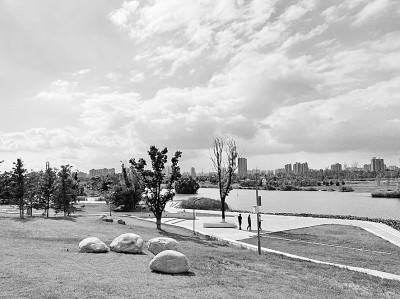
Overlooking the Hancheng section of the Shaanxi Yellow River Wetland Provincial Nature Reserve.
Photo by our reporter Li Ruichen/Guangming Picture
【Dharma Eye View】
The Yellow River for thousands of miles starts from the lofty mountains and stretches endlessly, rushing eastward into the sea. Winding along the word "ji", in the 719 kilometers flowing through Shaanxi, the Yellow River flows from north to south, nourishing and irrigating the land of the Three Qin Dynasty. However, the problem of soil erosion is a challenge and hidden danger that endangers the middle and lower reaches of the Yellow River.
The Yellow River is our mother river. General Secretary Xi Jinping emphasized that protecting the Yellow River is related to the great rejuvenation of the Chinese nation. The ecological protection and high-quality development of the Yellow River Basin is of vital importance to Shaanxi and the whole country. How to improve the ecological environment of the basin? How to transform from excessive intervention and over-utilization to natural restoration and recuperation... Focusing on these propositions, Sanqin Dadi has become more solid in exploring the ecological management and restoration of the Yellow River Basin.
Formulate and revise regulations on mountain closure and grazing prohibition, river management regulations, implementation of sand control laws, air pollution control regulations, solid waste pollution prevention and control regulations... In recent years, Shaanxi Province has tailored local regulations for the ecological protection of the Yellow River Basin32 Documents to provide legal compliance for the mother river to have cleaner water, greener mountains and greener slopes.
How effective has been the governance of the Yellow River Basin over the years? Recently, the reporter walked into Shaanxi along with the China Environmental Protection Century Tour, led by the General Office of the Standing Committee of the National People's Congress, to visit the current status of ecological protection and restoration in the Yellow River Basin.
"Water" is the key to being the ecological guardian of the Yellow River
Revision of the regulations on the protection of drinking water sources, the regulations on water and soil conservation, and the regulations on the protection and management of the Weihe River Basin... Focusing on the central term "water", the legislation of the Yellow River Basin continues to advance, and the improvement of the water environment of the Yellow River Basin follows.
The Fenghe River, a river originating from the northern foot of the Qinling Mountains, merges into the Weihe River, the largest tributary of the Yellow River, in the Xixian New District of Shaanxi Province.
In the past, there were weeds and rubbish on both sides of the Fenghe River.
On July 20, the reporter came to the Fenghe River, but before his eyes was a different scene: the blue waves are clear and shallow, the weeping willows are Yiyi, and the egrets pass by the river from time to time.
On the bank of the Fenghe River, there is an automatic monitoring station for the full-indicator water quality of the Fenghe River. Wang Tuan'an, general manager of the Shaanxi Environmental Protection Company, pointed to the numbers on the testing instruments and explained to reporters one by one: "COD (chemical oxygen demand) 2.743, total phosphorus 0.0599 , Ammonia Nitrogen 0.275...Every item is better than the assessment index."
"If the ecology is good or not, just look at the birds." Xu Junqian, deputy director of the Management Committee of Xixian New District, said, pointing to the egrets passing by from time to time on the water. "The water quality is better, the environment is beautiful, and the birds will naturally fly back." 2018 Over the years, there have been more and more fish such as carp and crucian in Fenghe, and there are no fewer than 20 species of birds that can be observed daily.
"In the management of the Fenghe River, we adhered to the principle of'bay with the bay', retaining the original river course, as well as the naturally formed water surface and islands, and increasing the beach area." Xu Junqian said, from the previous "sewage ditch" to 2019 , In 2020, it will remain in Surface Water Class II for two consecutive years, and the clear Fenghe River has returned.
Along with the Fenghe River, there are other rivers that "Eight Waters Around Chang'an".
As early as the Han and Tang Dynasties, the "Eight Waters around Chang'an" can be called a scene—surrounding Xi'an, with Chan and Ba in the east, Chu and Lu in the south, Feng and Lao in the west, and Jing and Wei in the north.
However, this scene has disappeared due to changes in the ecological environment and other factors. The "eight waters" are still there, but they are no longer clear.
In order to reshape the "eight waters around Chang'an" and improve the water environment of the Yellow River Basin, Xi'an has made great efforts in river and lake governance in the past ten years, especially in 2019, it issued a three-year action plan for the protection and governance of the river and lake system in Xi'an. , Began to start the global water control work.
According to Dang Zhankui, chief engineer of the Water Affairs Bureau of Xi’an, Shaanxi Province, in the water management work, Xi’an has implemented the “Chang’an Eight Waters” and the Heihe River and Xinhe River and other five key rivers in the whole basin, and promoted the Doumen Reservoir, Meipi Lake and the moat. Comprehensive treatment project construction... "We hope that by the end of 2021, the goal of connecting rivers, rivers and lakes, clear waters, long rivers, and fish with shallow bottom can be achieved." Dang Zhankui said.
Put on "green clothes" for the Loess Plateau
Protecting the Yellow River means that the river is rooted on the bank.
Upstream from Xi'an to the Yellow River, stop in Hukou Town, Yichuan County, Yan'an City, with verdant mountains and endless stretches of woods, decorating the scenery on both sides of the Yellow River.
However, 20 years ago, this piece of land located in the Jinshan Gorge was covered with abrupt rocks, exposed loess and sparse vegetation.
"The more incomplete the ecological system and the steeper the terrain, the more serious the soil erosion." said Hao Yunfeng, deputy director of the Yichuan County Forestry Bureau.
In order to change this situation, for many years, Yichuan County has insisted on afforestation on cliffs and implemented greening projects in key areas of Shanxi-Shanxi Canyon.
"Building stone pits", "backfilling guest soil", "deep planting and deep burying, roots cultivating soil"... After more than ten years of continuous exploration, the foresters in Yichuan County have summed up a set of effective cliff afforestation techniques and methods.
Although the technology is well understood, planting trees on the cliff is not an easy task.
With saplings on his back, hanging ropes, and moving tightly on the cliff, for Wang Yonghong, the captain of the afforestation team at Xuejiaping Forest Farm in Yichuan County, every sapling he and his team planted has gone through hardships.
"There are many times when we have to descend more than ten meters from the top, and when we descend to the last two or three meters, the ropes that hang us are loosened, and my heart is really nervous." Wang Yonghong said.
Today, Wang Yonghong's afforestation team has grown to more than 50 people. In Yichuan County, there are 8 such afforestation teams.
Up to now, Wang Yonghong and other foresters have completed 35,000 mu of intuitive slope greening and 38 kilometers of highway greening in the Jinshan Gorge.
Wuqi County, Shaanxi Province, was once considered to be one of the counties with the most serious soil erosion in the upper and middle reaches of the Yellow River. At the end of 1997, the soil erosion area was 3,693 square kilometers, accounting for 97.4% of the county's land area.
"Planting a slope in spring, harvesting a bag of grain in autumn" "The next heavy rain peels off a layer of skin, and the mountains and rivers are full of mud." In the eyes of Yan Zhixiong, a representative of the Yan'an Municipal People's Congress and a villager in Wuqi County, this was once from Wuqi County. True portrayal.
Changes Since 1998, Wuqi County has decided to close mountains and graze, develop sheds to raise sheep, measure and verify ration fields on a hill-by-hill and block-by-field basis. Except for the 2 mu of ration fields per capita, the rest of the sloping arable land has been withdrawn.
Since then, green has become the dominant color in Wuqi County.
During the more than 20 years of returning farmland to forests, the annual soil erosion modulus of Wuqi County dropped from 15,300 tons per square kilometer in 1997 to the current 5,000 tons, and the annual rainfall increased from 478.3 mm in 1997 to 582 mm.
"The original barren hills have turned green. In some places, the vegetation is too dense for people to walk through." Yan Zhixiong said, after returning farmland to forests, the climate is getting wetter and humid. It will rain."
From desolate to full of vitality, the banks of the Yellow River in Shaanxi are gradually lit up by green.
It is understood that since 2019, the Yellow River Basin in Shaanxi has completed a total of 10.98 million acres of forests, of which 899,500 acres have been arranged for returning farmland to forests and grasslands, 997,000 acres have been implemented for the Three-North Shelterbelt, and 1.155 million acres have been closed for natural forest resource protection projects. The ecological functions of natural forests are constantly improving.
Grasping the relationship between water and sand to adjust this "bull nose"
The Jiuqu Yellow River has tens of thousands of li sands, and the waves are scouring and wind blowing from the end of the world.
Shaanxi is the focus of soil erosion control in the Loess Plateau, and Shaanxi is the key to reducing sediment influx into the Yellow River.
The adjustment of the relationship between water and sand is the “niubi” of the problem of soil erosion in the Loess Plateau.
Yanchuan County, Shaanxi Province, is located in the gully area of the loess hilly and gully area in northern Shaanxi. The terrain in the territory is broken and the ravines are vertical and horizontal. It is a key area of soil erosion in the middle and upper reaches of the Yellow River.
In Jiajiaping Town, Yanchuan County, the reporter saw a large Majiawan silt dam with a height of 30.5 meters, a top length of 310 meters, and a width of 6.5 meters.
The silt dam is composed of a dam body, a culvert pipe and a spillway. It was completed at the end of 1971 and became full in 1985.
Nowadays, lush corn grows on the dam land, and the once ravine region has transformed into a thousand acres of fertile land.
According to Ren Hongxiang, the leader of the soil and water conservation team of Yanchuan County, the silt dam is a kind of dam construction for people living in the Loess Plateau. In the long-term production practice and preventing soil erosion, a kind of dam construction is created for the purpose of blocking mud and silt. The land that is blocked by mud and silt is called dam land.
"Damming is like repairing a silo, and blocking mud is like accumulating grain. The village has a hundred acres of dams, and you will never be afraid of drought." This proverb refers to a silt dam.
"Practice has proved that silt dams are a key measure for soil and water conservation in the Loess Plateau." Ren Hongxiang said that large-scale silt dams have blocked the passage of sediment from the source to the downstream, and the effect of sediment reduction is very obvious.
Not only can it effectively regulate the relationship between water and sand, the silt dam is also called "grain storage", "pocket" and "cornucopia."
"The dam land has fertile soil, high organic matter content, high yield and stable output during droughts and floods. The grain output is 2 to 3 times that of terraced fields and 5 to 8 times that of sloping fields." Ren Hongxiang said.
Up to now, 1,825 silt dams have been built in Yanchuan County. According to estimates, through the improvement of small watersheds, the conversion of farmland to forests, and the construction of silt dams, the inflow of yellow sediment has been reduced by 125.75 million cubic meters.
"Northern Shaanxi is the region with the most serious soil erosion in China. The gully topography of the Loess Plateau provides unique conditions for the construction of silt dams." Fang Fang, deputy dean of the National People's Congress and deputy dean of the Northwest Institute of History, Environment and Economic and Social Development of Shaanxi Normal University Lan said that Shaanxi Province has built 34,000 silt dams, accounting for 58% of the country's total, holding 5.8 billion tons of mud, silting up 860,000 tons of land, irrigating an area of 4,000 hectares, and increasing grain production by 400 million kilograms.
Protecting the Yellow River, the mother river, is a major ecological proposition given by the times, and Shaanxi and even the whole country dare not slack in the slightest.
Ecological governance and restoration are not a day’s work. What is gratifying is that now the Yellow River Basin has cleaner water, greener mountains and greener slopes, and the green landscape continues to extend.
(Our reporter Li Ruichen)