
Characteristics of "flood" Changes in river scale Risk confirmation on hazard map August 13, 20:14
It has been pointed out that this heavy rain will continue over the next week, no matter where and when it rains.
Heavy rains for a long period of time increase the risk of flooding, but the way "floods" occur and the timing of evacuation also depends on the size of the river.
We have summarized the characteristics of "flood" and how to read the hazard map.
How to read the hazard map?
The "hazard map" created by the local government can be used as a reference when deciding to evacuate.
This is a method to check from a computer or smartphone.
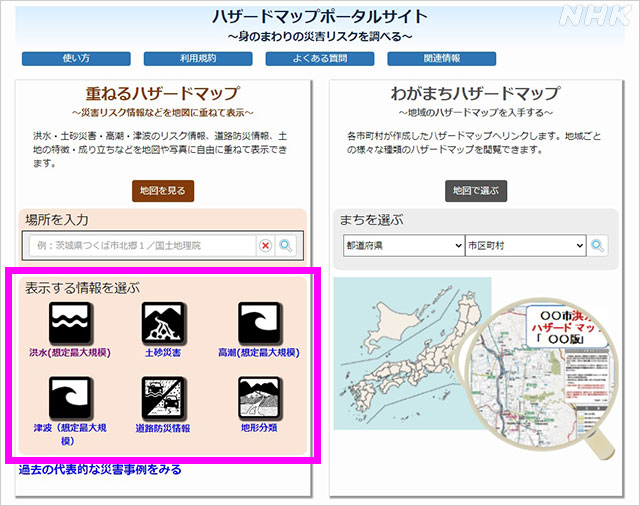
The "Overlapping Hazard Map" published by the Ministry of Land, Infrastructure, Transport and Tourism is a site that allows you to overlay and display places at risk of floods and sediment-related disasters on a single map.
On the site, first select the "disaster type" you want to know.
Click icons such as "flood" and "earth and sand disaster" to display the locations at risk of disaster on the map.
Then enter the place you want to see in the space at the top of the screen and click the place you want to check in detail to understand the disaster risk of that place.
"Hazard map" checkpoint
If your home is within the expected inundation range, also check the inundation depth.
If the expected inundation depth is 3m or more, the one-story building will be submerged, and even if you are on the second floor, it will be inundated.
In addition, the water level is high and the speed of the flowing water is high in the area designated as the "presumed flooding area such as collapsed houses", so there is a risk that the entire building will be washed away.
Make sure in advance that your home is a place where you can stay in the event of heavy rain.
Past flood damage
Next is the characteristic of "flood".
Since the way floods occur depends on the size of the river, the timing and precautions for evacuation also differ.
Small and medium-sized rivers “Rapid rise in water level”
Small and medium-sized rivers are narrow and the water level rises sharply.
In 2016, Typhoon No. 10 flooded the Omoto River in Iwaizumi Town, Iwate Prefecture, with the water level rising in a few hours and flooding the elderly facilities along the river, killing nine residents.
Also, in the mountains, there is a risk that not only water but also driftwood will damage the building.
If you are in a place where inundation is expected, if the local government issues information on evacuation of the elderly, etc., the elderly who take time to move need to take early action such as starting the move.
Large river “Wide area is flooded for a long time”
Once a large river overflows, a large area is flooded for a long time.
In the heavy rains in the Kanto and Tohoku regions in 2015, one-third of Joso City in Ibaraki Prefecture was flooded by the flooding of the Kinugawa River, and it took 10 days for the water to drain.
Large river “After the rain stops, the water level rises”
The water level may continue to rise even after the rain has stopped.
In Typhoon No. 19 in 2019, flooding occurred one after another after the heavy rain special warning was lifted, and flooding was confirmed 9 hours after the special warning was lifted in the upper reaches of the Abukuma River in Fukushima Prefecture.
Once you have evacuated, be sure to check the water level of the river and the evacuation information of the local government even if it stops raining before returning.
Risk of disaster even in places not shown on the hazard map
On the other hand, there are many small and medium-sized rivers for which inundation is not yet assumed on the hazard map, and there is a risk of damage in these areas.
It is important for people who live near or low in the river, even if the risk is not shown on the map, to be aware of their surroundings and local government information and move to a safer place.
On the Japan Meteorological Agency website, you can check the "flood risk distribution" analyzed based on rainfall.
You can search by "Kikikuru".
Confirm before danger approaches
Information on hazard maps and evacuation can also be found on the NHK website "Your Weather / Disaster Prevention" and "NHK News / Disaster Prevention App".
You can also check the water level of the river on the website "River Disaster Prevention Information".
Understanding the risks of your own home in advance will lead to early evacuation.
Please check once before the danger approaches.
▽ "Hazard map portal site of the Ministry of Land, Infrastructure, Transport and Tourism"
https://disaportal.gsi.go.jp/
▽ NHK "Your weather and disaster prevention"
https://www.nhk.or.jp/kishou-saigai/hazardmap/
▽ "Japan Meteorological Agency Homepage"
https://www.jma.go.jp