
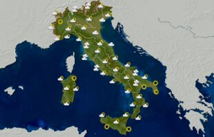
Weather situation Italy next few hours
Share
by Tiziana Di Giovannandrea
05 April 2021 What is expected in the next few hours is the arrival of a cold front coming from the North Pole that will bring strong winds, a sharp drop in temperature, rain, snow and temperatures up to 15 degrees below the seasonal average after the weather sunny weather that characterized almost all of Italy on Easter Monday.
Experts foresee, from tomorrow, a winter queue on the Peninsula with cold air that will head towards the Mediterranean from the North Pole.
The weather will worsen quickly from the Alps towards Triveneto and Emilia Romagna with rain and snowfall on the Alps and the Apennines.
As the hours pass, the cold front will arrive on Marche, Tuscany, Umbria, Lazio, Abruzzo and Molise and then continue towards the south. The passage of the disturbance from Greenland will be accompanied by a strong wind.
The significant drop in temperatures will give rise to a winter climate with the return of snow at relatively low altitudes in the North-East and the Center.
As for the
temperatures
in the immediate next few hours, we will have lower lows in the Central-Northern regions;
a slight increase in Sicily, Calabria and southern Puglia;
stationary elsewhere.
Highs down on southern regions, Sardinia, southern sectors of Tuscany, Umbria, Marche, Liguria and western Piedmont;
stationary in Trentino-Alto Adige and northern sectors of Veneto and Friuli-Venezia Giulia.
Winds
: Moderate to strong northerly winds over Sardinia, with evening attenuation.
Moderate North Westerners on Sicily and Calabria with reinforcements on the Apennine areas of Calabria;
northern moderates on the rest of the country with afternoon reinforcements on Piedmont, Lombardy and Liguria.
Seas
: agitated Sea and Sardinia Channel with evening attenuation wave motion;
very rough southern Tyrrhenian, southern Adriatic and Ionian;
moved the remaining basins.