
Share
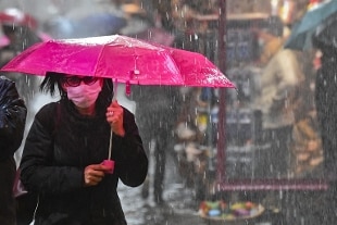
January 22, 2021Week end marked by bad weather in most of Italy, with rain, wind and snow that will sometimes hit many regions violently.
If tomorrow the last rains will wet Lombardy, the Northeast and all the central-southern Tyrrhenian sectors, on Sunday a new wave of heavy rains will hit Tuscany, Lazio, Umbria, Campania and finally on Calabria.
Still a lot of wind, storms on the exposed coasts and snowfall which however will drop both in the Alps (800 meters) and in the Apennines.
State of attention in Veneto
In Veneto, attention was paid to heavy rainfall that could cause hydraulic and hydrogeological risk, and to strong winds.
The bulletin of the decentralized functional center of the regional civil protection is valid for rains from 2pm today until 6pm tomorrow, Saturday 23 January, and for snowfalls until midnight on Sunday 24 January.
For winds, the warning is valid until tomorrow morning for the coastal and lowland areas, and until midnight tomorrow for the pre-alpine reliefs.
South Tyrol, high level of attention for big snowfall
The Civil Protection Agency has declared the level of attention alpha for South Tyrol from this afternoon until Saturday evening.
In the night between and tomorrow morning, according to the head of the evaluation conference and director of the functional center, Willigus Gallmetzer, medium and low-altitude snowfalls are expected throughout the province with precipitation that will reach 30 - 40 centimeters of snow.
The eastern part of the province is particularly interested.
In the Brenner area about 40 centimeters of snow are expected and in the Dolomites up to 70 cm.
The least affected area will be Val Venosta.
The precipitation limit will oscillate between 500 and 1200 meters of altitude.
Orange code extended in Tuscany The orange
code for hydraulic and hydrogeological risk in northern
Tuscany has been extended
until 1pm tomorrow, Saturday 23 January, while the orange code for storm surges on the north coast starts from midnight today, Friday, and will last for the whole tomorrow, Saturday.
The yellow code has also been extended until 1pm tomorrow, Saturday, on the rest of the region for rains, thunderstorms and wind, to which is added the yellow code for storms until midnight tomorrow, Saturday.
The unified operations room of civil protection issued them for the persistence of the disturbance that is driving Atlantic wet currents towards Europe, also affecting Tuscany.
Red alert in Reggio and Parma
Red alert for hydraulic risk in Reggio and Parma from 12 today, Friday 22 January, and until midnight tomorrow, Saturday 23 and orange, always for today and the whole day of tomorrow and for full of rivers in seven provinces: beyond Parma and Reggio Emilia, Piacenza, Modena, Bologna, Ferrara and Ravenna.
It was issued by the Regional Agency for Territorial Security and Civil Protection of Emilia-Romagna on the basis of the forecast data of Arpae.
Much of the Emilia-Romagna area will in fact be hit by a series of intense meteorological phenomena that could cause significant effects on the ground.
Extended alert in Liguria
The Ligurian agency Arpal has extended the weather alert for rains, thunderstorms and snow until tomorrow, which should have ended within the day.
In the center and in the Po slopes of the east it will be Yellow (the lowest, until midnight while in the east it will be Yellow until 8 am on Saturday morning. Also in the east, it will be Orange (medium) for large basins until 6 am tomorrow. as regards the snow, Yellow alert from 5 pm today until 3 am tomorrow on the western Po slopes.
Strong storms, yellow alert in Campania, parks and cemeteries closed in Naples
The Civil Protection of the Campania Region has issued an alert notice weather with yellow level hydrogeological criticality starting from 9pm today and valid until 3pm tomorrow, Saturday January 23. The alert covers all areas of Campania except for 4 (Alta Irpinia and Sannio) and 7 (Tanagro) where the weather conditions are such as not to cause criticality (Green level). Scattered precipitation is expected, predominantly showers and thunderstorms, locally strong winds from the western quadrants with gusts, rough sea with
possible storm surges along the exposed coasts, and in particular those of the coast of the Piana Campana, Naples, the islands of the Gulf and the Sorrentino-Amalfi peninsula.
Storm phenomena will be characterized by forecasting uncertainty and rapidity of evolution.
The municipal administration of Naples ordered the closure of the city parks and cemeteries for tomorrow on the basis of the weather alert with yellow criticality issued by the Civil Protection of the Campania Region.