
Bad weather until the Immaculate Conception.
Milan and Bologna wake up white
Bad weather, it is still red alert in the Crotone area.
Conte: the government will support the citizens
Bad weather: disturbance from northern Europe brings rain, thunderstorms and some snow
Bad weather, the first snowflakes in Milan
Bad weather.
Sardinia: Bitti wakes up in the mud.
Sicily, damage to Catania
Share
03 December 2020 Snow and rain will not leave Italy even for this weekend.
Indeed, experts announce a further deterioration and a marked drop in temperatures.
The Civil Protection calls for the utmost caution when traveling, recalling that strong thunderstorms are already expected in Campania and north-eastern Sicily, Basilicata, Puglia, part of Calabria and Abruzzo and in the central-northern sectors of Sardinia.
The snow fell again during the night in some Emilian cities: in Bologna the Fire Brigade had to intervene in various areas of the province, where some trucks that went off the road and trees fell on the road, while in the capital the means to clean up the streets.
The major problems were found in the Apennines and in the foothills.
Last night, for example, in Monzuno and Monghidoro, the brigade rescued two vehicles on the Sp 61 and in the Frassineta area.
In the past few hours, the 'People Mover', the little train on a monorail between the railway station and the 'Marconi' airport, also had a technical stop due to a snowfall.
In Piacentino, some municipalities remained without light for a few hours after the white blanket settled at 15-20 centimeters.
In Romagna there were no significant snow phenomena except at the highest altitudes.
For today, Arpa Emilia-Romagna foresees an improving situation.
Flooding in the Palermo
State Road 113 "Northern Sicula" temporarily closed to traffic in the municipal area of Isola delle Femmine (Palermo) due to the flooding of the underpass.
Anas and law enforcement personnel on the spot.
The underpasses of the Sicilian capital, affected by persistent rain for hours, were also monitored.
Active snow plows in the Frosinone
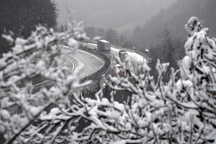
area In the Frosinone area, snow on the Forca D'Acero Sr509 between km 9 + 000 and 12 + 000, where snow plows by Astral spa are active.
Ice on the Sp128 Campostaffi and Sr411 DIR of Campocatino where salt spreaders are active.
Pay attention.
Astral Infomobility communicates it.
Still alert in Lombardy for rain and snow
The bad weather alert remains throughout Lombardy where from yesterday in the plains up to the Bergamo valley the snowflakes made their appearance, triggering the municipal emergency plans.
Discomforts due to heavy snowfalls are recorded in the Oltrepo Pavese where many roads have remained impassable, especially at high altitude on Mount Penice.
Situation under control in the plains, where Coldiretti tractors in Brescia, Pavia and Como have also been on the field since yesterday.
The forecasts show a stalemate until the Immaculate Conception on the whole region.
This morning still rain in Bresciano and in the valleys where new snow showers are likely even during the day.
From tomorrow new worsening: heavy rains and snowfalls above 600 meters
Starting from tomorrow, new worsening due to a cyclonic vortex descending from the United Kingdom will activate intense siroccal currents that will push a strong disturbance that will be piloted over the weekend by a low pressure center that will be located in central Italy.
Tomorrow, Saturday and Sunday will be three days of widespread bad weather and copious snowfalls in the Alps above 1000-1200 meters.
The weather will gradually and rapidly deteriorate in the North, especially in the Northwest and in the Alps.
The snow will begin to descend, as well as on the Alps, also in the plains of Piedmont with most of the cities whitewashed by about 5-7 cm of white mantle.
Heavy rains and in the form of a storm will hit Liguria, western Emilia and even Lombardy.
It is worse in Tuscany, Lazio and Sardinia.
Abundant snowfalls will
affect the Alps above 600 meters.
On the rest of Italy it will be drier.
On Saturday, the disturbance moves to the Northeast, on the Tyrrhenian center and on the Ionian areas.
It will be bad weather in the North (very abundant snow on the Alps at 900 meters), in Tuscany, Lazio, Sicily and Calabria.
Storms are expected over these regions.
Winds of Scirocco will blow with gusts of up to 120 km / h on the Adriatic and Ionian Sea.
In Venice it will still be Acqua Alta.
On Sunday, things will not change much, almost all of Italy will be underwater with heavy rains at times.
Only the Northwest and the Adriatic Center will see little rain.
Stormy sirocco on the Adriatic Sea that will be rough or even big.
Acqua Alta in Venice up to 140 cm.
There is no good news even for the Immaculate Conception.