
- Milan, heavy thunderstorms in the night: the Seveso floods, Lambro on guard level
- Weather, Italy split in two: storms in the north and sirocco in the south
Share
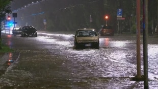
May 15, 2020 Record rain and discomforts in Milan due to the flooding of the Seveso and the continuous growth of the Lambro level. On the city, already at the center of the coronavirus emergency, bad weather has also gone wrong. On the night between Thursday and Friday, about 100 millimeters of water fell, with peaks of 130 mm, about a third of the rain that has been from January to today. Numerous interventions during the night and at dawn of the Civil Protection and firefighters, 30 local police patrols employed in aid.The flooding, which started around 3, stopped only after five hours. Lightning and thunder repeatedly and then a 'bomb' of water. At least 200 calls to the emergency number for fallen trees, roads flooded after manholes also blew, especially in the Niguarda area, where there was a blackout in some neighborhoods, but also in the western part of the city, for example in Baggio , with trunks fallen on parked cars. Don Antonio Mazzi's Exodus Foundation also evacuated to the Lambro Park, while the southern Lambro overflowed from the embankments in the Opera area affecting some homes. Disruptions in the Rho area due to the flooding of the Lura torrent, which spilled its waters into the Villoresi canal, which flooded some basements.
The violent storm that hit the city also caused inconvenience to public transport. "The consequences of bad weather force us to change the service of some lines. On the surface circulation has slowed down on the entire network", the Milanese transport company (ATM) said early in the morning. As for the green metro, the trains for several hours were replaced by buses on the Famagosta-Assago and Famagosta-Abbiategrasso routes. While, after a couple of hours in which the Zara (M3 and M5) and Marche (M5) stops were closed due to the flooding outside caused by the flooding of the Seveso, the circulation returned to normal. Then, the passing convoys resumed the stops. Consequences of bad weather also for trams, buses and trolley buses, with the service that slowly returned to almost normal, after several lines were affected by changes in the route. Due to bad weather, the Negrotto underpass was also closed and the Rubicone underpass was closed only for a limited period during the night, while it was then decided to evacuate the communities of the Lambro Park out of prudence, "as the Lambro continues to rise and into the Park is beginning to flood the meadows ", the councilor for Mobility and Public Works, Marco Granelli, informed on Facebook.
After the record rain, the mayor Giuseppe Sala also spoke in a video on social media. He assured us: "We are doing a lot of cleaning work in the tomb part of the Seveso but without the three rolling tanks north of Milan the situation will not be resolved. We are concerned about Bresso, the race has been awarded but it is two years that we are facing remedies ". For the Regional Councilor for Civil Protection, Pietro Foroni, "it is clear that as long as the rolling tank system is not completed and implemented, these situations are likely to repeat themselves and this is why in recent years this planning has had a very strong acceleration both by the Lombardy Region and the Municipality of Milan ".
Weather: weekend with the heat, from Tuesday rains and thunderstorms
Early summer in the center and south but next week will be characterized by the return of heavy rains in many regions. This is predicted by the experts of the website www.ilmeteo.it according to which "African high pressure is struggling to impose itself decisively on our country": today thunderstorms will still be present in all the northern regions, while in the rest of Italy they will register temperatures even above 30 degrees.
The scenario will change significantly next week: after a Monday with stable and sunny weather over most of the peninsula, "a cyclonic vortex will rapidly move from the Balearic Islands to our country. Bad weather will affect most of the center from the early hours of Tuesday, dispensing heavy rains and thunderstorms ". According to the experts of ilmeteo.it "around mid-week the low pressure center will involve Sardinia and target the southern regions, with locally intense rainfall on Campania, Basilicata and Puglia. Thunderstorms expected also on Lazio, with a fairly high risk of hailstorms and strong winds. On the rest of the country there will be more sunshine. " To wait for a return in style of high pressure we will have to wait for the weekend of 23 and 24 May.