
- Bad weather. Discomforts in connections with the Pontine islands. Snowstorm, state lock 36
- Bad weather returns to the center-north, weather alert for storm winds
- Bad weather. Strong wind in half of Italy, in Milan a tree falls in Corso Sempione, damaged cars
Share
March 02, 2020 After a long period dominated by high pressure, with the specter of drought advancing day after day, time is bound to change in our country. Experts point out that a truly unstable week will begin today.Already in the early hours of today, a low pressure vortex has formed which from the Ligurian Sea is slowly beginning to move its center of gravity towards the northern regions. In the next few hours scattered rains are expected also in the form of downpours starting from the North-West, on Tuscany but rapidly moving towards the rest of the northern regions.
Attention also to the snow that can fall on the whole Alpine arc, on average around 1000 meters; some snow at high altitudes will also whiten the northern Apennines. Afterwards the precipitations will move towards Umbria, the Marche up to Lazio. The cyclone will then move very slowly towards the east, adversely affecting the meteorological picture on Italy also for the whole day of Tuesday 3, when the only areas of the North-West will have a drier type of weather with wide spells.
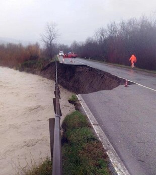
Collapsed bridge over the Paglia river, in the province of Siena
The bridge, closed since 2014, in the municipality of Radicofani, which crossed the river Paglia, would collapse on the night between Sunday and Monday. Some motorists passing the area saw the bridge collapsed and sounded the alarm. Now there will be the removal of the rubble. The bridge, located at the 'Scaldasole' junction of the Cassia, was unusable since autumn 2014, and in that stretch the road was closed to transit and detours have long been made.
During the night the intense atmospheric precipitations caused the flood of the Paglia river which had already compromised two spans of the bridge. In the section, at the 152,500 km the Province had already created a variant to divert traffic and to allow the restoration works of the bridge that crosses the Paglia river. After the return of the artery under its management, Anas has included the demolition and reconstruction of the work of art in its financing plans. The planning of the demolition activities has already been completed and the process for obtaining the necessary authorizations from the relevant bodies is being finalized, after which the works will be started.
It snows, Colle della Maddalena and Tenda are closed
It has been snowing since last night on the Cuneo mountains and the international Maddalena hill between the Stura valley (Cuneo) and southern France and the Tenda hill in Limone have been closed. The stop to all means between Argentera and the state border towards the Queyras valley was communicated by the Anas "indefinitely" and "in both directions". The tent was also closed for some heavy vehicles in difficulty on the French side.
The snow returns to the Dolomites
After more than two months without significant rainfall, the snow returns to the mountains of Trentino Alto Adige. Up to 50 cm of fresh snow is expected in the next few hours, especially in the southern Dolomites and in the Val d'Ultimo. In other areas, between 20 and 40 cm are expected. It is the first copious snowfall since before Christmas. The snow quota is expected on average around 900 meters, and locally also at lower altitudes during the most intense phases of precipitation. Precipitation will end on Tuesday with simultaneous reinforcement of winds from the north which will produce strong gusts of foehn in the valley bottom.
Thick snow and cold in Valtellina
Collapse of temperatures of several degrees on the entire provincial territory of Sondrio and dense snowfall at altitudes above 1000 meters. In Valtellina and Valchiavenna the "tail" of winter with Alpine passes which can only be traveled with snow chains or winter tires. On the valley floor, however, pouring rain since this morning.
Yellow alert for rain in Liguria
From the early morning, rainfall affects the whole of Liguria with intensity generally between weak and moderate. The regional agency for the protection of the Ligurian environment (Arpal) has confirmed the yellow weather alert for widespread and thunderstorm rains taken from 8. The end of the alert on Ponente, Val Bormida, the Savona hinterland and Stura valley, remains confirmed at midnight on the center and inland of Levante while on the Levante in the large basins it extends from midnight to 2 tomorrow, remaining until midnight in the small and medium ones.
In the morning, the hourly maximums are recorded in the Imperian hinterland (27.8 in Ceriana, 27.6 in Airole, 25.6 in Montalto Ligure). Also noteworthy is the 23.2 in Genova Pegli (where between 8.20 and 8.35 9.6 mm fell in 5 minutes and 15.8 in 15 minutes). From midnight 50.6 are reported in Airole (Imperia), 49.6 mm in Testico (Imperia), 47.4. in Colla Rossa (Ventimiglia, Imperia). Also noteworthy is 44.6 in Isoverde (Campomorone, Genoa), 44.2 in Monte Pennello (Genoa). Yellow alert also on Lazio, orange in Veneto.