
- Weather Check the weather forecast
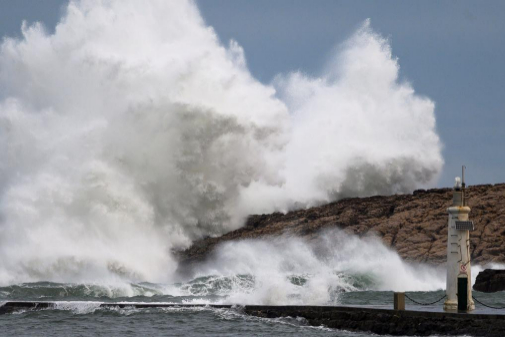
The blizzard Gloria on the Mediterranean will feel its effects this Sunday with locally strong or persistent rainfall in the Community of Valencia and the Balearic Islands, snowfall in the interior of the peninsular east half, intervals of strong wind and a decrease in temperatures. In fact, before the arrival of Gloria the Aemet has activated the red alert for snow and coastal phenomena in Alicante and Valencia , and for coastal phenomena in Ibiza and Formentera .
The special warning of adverse events, issued by Aemet, which has a "very high" degree of probability, exceeding 80%, begins this Sunday and lasts until Tuesday 21 .
The combination of Gloria's position and the powerful European anticyclone, centered on the British Isles, will favor the entry of a mass of cold air from the interior of the continent, which together with the humid entrance of the Mediterranean will cause snowfall at very low levels of the Eastern peninsular third.
The State Meteorological Agency (Aemet) highlights that this Sunday will be cloudy with precipitation throughout the north end and peninsular eastern third, Balearic Islands and Melilla , being able to be locally strong or persistent in the Valencian and Balearic communities.
The rains could extend, with less intensity, to the rest of the Peninsula, except for the western end, where it will be little cloudy with only a few cloudy intervals. In the Canary Islands, slightly cloudy increasing at cloudy intervals.
There will be snowfall in mountain areas in the north and in the interior of the peninsular east half . The snow level will be located at 400-700 meters in the peninsular northwest; 600 to 1,000 meters in the northwest, center and east of the peninsula, and 800 to 1,200 meters in the south.
Temperatures will generally decrease in most of the Peninsula and the Balearic Islands , and without changes in the Canary Islands. Frosts will occur in central and northern peninsular areas , being locally moderate.
The winds will blow from the northeast in most of the country, with strong intervals throughout the eastern peninsular, Balearic and Melilla, as well as in mountain and coastal areas.
Prediction by Autonomous Communities
- GALICIA : Cloudy intervals decreasing in the morning to slightly cloudy or clear, except in the Lucense towns of A Mariña (Lugo) and north of Os Ancares where it will remain cloudy or with cloudy intervals throughout the day, with weak rainfall at dawn, of snow above 1000 meters .
Temperatures will decrease, except the minimum at the far north, which will remain with few changes. The minimum temperatures will be reached at the end of the day in much of the Community.
There will be weak frosts in the south and on the mountain of Orense , with northeast wind increasing in intensity at the end of the day with probable strong intervals and very strong gusts in the far north.
- ASTURIAS : Cloudy, occasionally covered, with precipitation, more intense and frequent during the first half of the day and weaker and occasional during the second. The snow level between 800-1000 meters, going down at the end of the day to 500-600 meters .
The minimum temperatures, which will be reached at the end of the day in much of the Principality, without significant changes. Maximum temperatures in decline. Weak frosts in the Cantabrian Mountains.
The wind will blow from the north and northeast without ruling out intervals of strong and very strong gusts on the western coast and high areas of the Cordillera .
- CANTABRIA : Skies covered with rainfall, especially at dawn, which in general will be weak although locally moderate in the western area where they will persist for most of the day. The snow level around 900-100 meters down to 500-600 meters .
The minimum temperatures in descent in the interior and with few changes in the coast, and maximum in descent locally notable. The minimum temperatures will take place at the end of the day and frosts will occur in the southern half , more intense in Campoo.
The wind will be of northern component, with very strong gusts in Cantabria del Ebro and high areas of Campoo and Liébana.
- BASQUE COUNTRY : Cloudy or overcast, opening clear on the coast in the afternoon. Weak rainfalls will occur at dawn , which will be more abundant in the west, where you can also precipitate the rest of the day. The snow level will be around 900 meters down to 400-500 meters in the afternoon .
Temperatures will be in decline, which will be more marked in the highs. The minimum temperatures will take place at the end of the day, with weak frosts in Álava .
North and northeast wind, more intense on the coast, without ruling out very strong gusts , especially on the coast and high areas.
- CASTILLA Y LEÓN : In the cloudy mountainous north covered with precipitation, which will be weak in the second half of the day. In the rest cloudy or covered at the beginning with rainfall in the east and Central System, weak in general and that in more dispersed form could extend to other areas, remitting in the morning and tending to cloudy intervals. The snow level will be 800 to 1000 meters down to 200 or 400 .
Falling temperatures, which may be notable in the highs in the southeast. Frost, more intense in mountain areas. Winds from north to northeast with very strong gusts, especially in mountain areas.
- NAVARRA : Cloudy or overcast decreasing at cloudy intervals in the afternoon, with early morning precipitation in the northwest and mainly in the south. The snow level will be around 900 meters at the beginning, down to 400-600 meters .
The minimum temperatures will remain unchanged, although locally decreasing, and maximum decreases. The minimum temperatures will take place at the end of the day. Frosts are expected in the northern half , which can be strong in the Pyrenees. The north component wind, temporarily with very strong gusts, more intense in the Pyrenees.
- LA RIOJA : Cloudy or covered with precipitation in the first half of the day, then tending to cloudy intervals. The snow level will go from 800 to 400 meters .
The minimum temperatures will be unchanged in the Valley and in decrease in the Sierra and the maximum in descent, with frosts, especially in the Iberian where they will be more intense. Winds from the north and northwest, with very strong gusts in the Sierra .
- ARAGÓN : Prevalence of overcast skies, with weak rainfall during the first half of the day, which will be restricted during the rest of the day to the southeast. The snow level will initially be 900-1200 meters in the northern half and 1400-1600 meters in the rest, down generally to 300-500 meters in the last hours .
Falling temperatures except in eastern Huesca , where they will rise locally. Frosts in the Pyrenees and in the Iberian, weak in the rest. Moderate north and northwest wind, with strong intervals and very strong gusts in the Pyrenees.
- CATALUÑA : Covered with rains and showers, especially in the southern half, where they can be locally strong and occasionally with storm, sending from north to south. The snow level will begin at 900-1,200 meters in the northern half and 1,400-1,600 in the rest, down in general to 400-600 meters in the last hours .
The rising morning temperatures in the central depression and evening decreases with minimums at the end of the day and frosts in the Pyrenees. The wind will blow from the north and northeast, from moderate to strong with very strong gusts in the eastern half and the Pyrenees, and lazy to moderate in the rest.
- EXTREMADURA : In the north and east cloudy at first without ruling out weak rainfall, tending to cloudy intervals. The snow level will be 1,000 to 700 meters. In the rest cloudy intervals.
Falling temperatures , with frosts in the Central System and Villuercas. Winds from the northwest, turning in the morning to the north and northeast, with very strong gusts in the Central System.
- MADRID : Prevalence of the cloudy skies, with mists and some morning fog bank in high levels of the Sierra. Precipitation during the morning in the Sierra and in the southeast that tend to remit in the afternoon.
The snow level around 900-1,100 meters down to 800 when the probability of precipitation decreases. Snowfall can accumulate up to 3 centimeters above 1,500 meters at dawn .
Falling temperatures, with minimum expected at the end of the day, There will be weak frosts in the Sierra, more intense in peaks and weak and scattered in the southeast. North component winds with very strong gusts in the Sierra .
- CASTILLA-LA MANCHA : Cloudy or cloudy intervals increasing to cloudy or overcast, with weak rainfall in the western half that will not reach the west end, which will be more intense in the eastern half and that in the afternoon tend to remit in Guadalajara and intensify in Ciudad Real .
The snow level will be between 1,100 meters in Guadalajara and 1,500 in the southeast, going down to 500-700 meters, being able to snow at any level in the south of La Mancha and the southeast at the end.
Falling temperatures, more pronounced at the minimum expected at the end of the day. Generalized weak frosts in the eastern half, more intense in mountain areas and not expected in lower areas of Albacete. Weak frosts scattered in the southeast of Ciudad Real.
The winds will be of north component and with very strong gusts in the west of Guadalajara , east of the Serranía de Cuenca and Sierra de San Vicente, which in the end could also be expected in the southeast of Albacete.
- VALENCIAN COMMUNITY : Cloudy intervals increasing from north to south to cover with widespread rainfall, locally strong and / or persistent in the south of Valencia and north of Alicante and significant snowfall in the interior. The snow level will drop rapidly from north to south to go from 1,000-1,400 meters to 400-600 meters .
Falling temperatures, with weak frosts in the interior and wind from the north and northeast, from mild to moderate in the interior, moderate to strong on the north coast and strong or very strong on the south coast.
- MURCIA : Cloudy or overcast skies with a probability of precipitation in the last hours, which will be more intense in the eastern half of the Region. The snow level will be around 1,000-1,200 meters to go down in the afternoon to 700-800 meters .
The minimum temperatures in descent , registering at the end of the day in many points; highs in descent in Altiplano and Northwest and without changes in the rest. Weak frosts in high areas. North component winds, occasionally strong with very strong gusts at the last hours in the Altiplano and Campo de Cartagena.
- BALEARIC : Sky from cloudy to overcast with precipitation that could occasionally be accompanied by a storm and that after noon will be persistent and locally strong. The snow level will drop to 1,300 meters in the afternoon .
Nighttime temperatures rising and daytime descending, with southwest wind turning during the morning to east and northeast moderate to strong with gusts of 80 kilometers per hour, which can reach 120 kilometers per hour in the north of Mallorca and in Pitiusas .
- ANDALUSIA : Cloudy skies in the western third; cloudy in the rest with rainfall, more likely in the eastern third and Melilla, less likely and intense the further west. The snow level around 1,000-1,200 meters down to 700-800 meters at the end .
The minimum temperatures without changes, reaching at the end of the day in many points; Maximum unchanged. Weak frosts in the eastern interior. The winds will be from the west component, turning to the north component, occasionally strong with very strong gusts on the Mediterranean coast and high areas .
- CANARY ISLANDS : Intervals of high clouds that will spread throughout the archipelago throughout the day, from west to east. In the afternoon they will be accompanied by intervals of low clouds in La Graciosa, Lanzarote, Fuerteventura and the north of the other islands.
Temperatures with few changes or slight rise. Low to moderate wind in general, from the northeast in the eastern province, keeping the east component in the west, and being more intense in mid-sized areas.
According to the criteria of The Trust Project
Know more- Spain
- Valencia
- Alicante
- Balearics
Politics Tilda of "unacceptable" the low investment of the central government in the province of Alicante
PolicyAlicante only received 0.65% of the public works of the State with Sánchez
Infrastructure The AP-7 Tarragona-Valencia-Alicante and AP-4 Seville-Cádiz toll roads, free since 2020