
- Weather Check the weather forecast
- Spain: The stormy Daniel loses strength but keeps 6 communities on alert
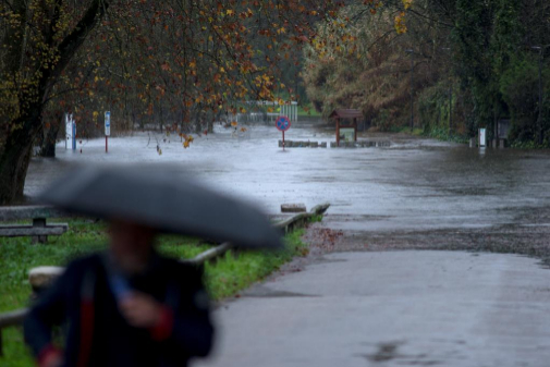
The deep and wide Atlantic stormy Elsa will be felt from this Wednesday in the western peninsular half , will affect the Mediterranean area on Thursday night to Friday and will arrive in the Balearic Islands to disappear throughout Saturday, so that it will bring about 72 hours of wind, rain and sea weather in large areas of Spain.
That storm will lead to a large part of Spain an intense flow of humid and temperate air from the North Atlantic that will send winds to the peninsula and Balearic Islands that will be loaded with moisture along its oceanic path. Thus, it will bring "a lot of precipitation," according to one of the spokesmen of the State Meteorological Agency (Aemet), Rubén del Campo. That adverse time will be longer on Thursday and Friday .
The wind will become a very adverse and widespread phenomenon , since very strong gusts of south and west component are expected throughout the peninsula. It is very likely that the gusts exceed 100 km / h in the eastern half and the peninsular center , and 120 km / h in mountainous systems.
The storm is associated with several very active frontal systems that will travel from west to east along the peninsula with widespread, persistent and locally strong rainfall in large areas. Del Campo said that the rains will be "large" because they will accumulate more than 100 liters per square meter in areas of Galicia, the western half of the Central System and southern Andalusia, so "water will be welcomed."
Given the characteristics of the air masses that will arrive from the west, with mild winds, the snow level will be relatively high . Only some snowfall is expected from Thursday in the mountains of the north of the peninsula, above approximately 1,200 meters.
The storm will also cause poor state of the sea in coastal waters , mainly in Galicia and the Gulf of Cádiz, areas where the significant height of the waves can reach five meters.
Notices
On the other hand, the arrival of Elsa on Wednesday afternoon has forced Aemet to activate warnings in 15 northern provinces due to various adverse phenomena .
The prediction of the Aemet indicates that there is orange warning (important risk, the second on a three-level scale) on the coasts of A Coruña and Ourense by winds of the south of force 8 and waves of four to five meters.
The yellow warning (risk, the lowest on a three-level scale) due to wind gusts of 70 to 90 km / h affects 15 provinces, specifically in A Coruña, Lugo, Ourense, Pontevedra, Asturias, Cantabria, Ávila (System Central), Zamora (Sanabria), Navarra (except the south), Álava (Nervión and Llanada basin), Guipúzcoa and Vizcaya (interior), and Burgos , León and Palencia (Cantabrian Mountains).
With yellow warnings for persistent rains of at least 40 liters per square meter in 12 hours are A Coruña (interior, west and southwest), Ourense (Miño and northwest) and Pontevedra (the whole province).
This Wednesday it will rain mostly in western Galicia, the Central System and Andalusia , and strong or very strong winds will blow in Galicia and high areas of the peninsular northwest half.
Temperatures will rise in the peninsular west half, especially in Galicia and the Cantabrian area. The hottest capitals will be Las Palmas de Gran Canaria and Santa Cruz de Tenerife (22ºC), and Alicante , Huelva , Palma de Mallorca , Tarragona and Valencia (19), while it will be colder in Ávila (8) and Cuenca , León and Soria (9).
According to the criteria of The Trust Project
Know more- Spain
Politics The PSC demands that Catalonia be a "nation" and a central government with ministers '100% yours'
Technology 72% of Spaniards are concerned about mobile security
Theater Documentary Theater: reality overdose at the High Season Festival