
China Weather Network News Today (May 25), the rainfall in the south has weakened significantly, there are still thunderstorms in the northeast, and there are local torrential rains.
Tomorrow, the rain will increase again in the south, and the precipitation in the north will decrease and weaken.
Before the end of the month, there will be frequent overcast and rainy areas in the south, and the accumulated rainfall will be large, so attention should be paid to preventing secondary disasters.
In terms of temperature, today, the north will cool down on a large scale and the heat will ease; the hot and dry weather will return again from the 27th to the 29th.
Frequent rain in the south
Yesterday, there was still strong rainfall in parts of the south, and strong convective weather occurred in North China, Northeast China and other places in the north. The monitoring showed that there was moderate rain in southeastern Heilongjiang, western Jilin, most of Liaoning and parts of eastern Inner Mongolia, and heavy rain in central Liaoning. Local heavy rains (50-54 mm) in Panjin and Yingkou; thunderstorms and strong winds of magnitude 8 to 9 in some of the above-mentioned areas, local level 10, and hail in Inner Mongolia, Liaoning, Heilongjiang and other places.
In addition, heavy rains occurred in parts of southeastern Fujian, southern Guangxi, eastern Hainan Island, and northern Taiwan Island. Local heavy rains (100-150 mm) occurred in Qinzhou and Fangchenggang in Guangxi, and Qionghai in Hainan.
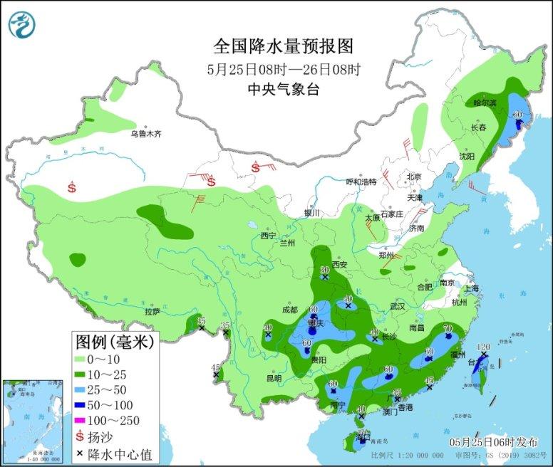
Today, the rainfall in the south has weakened significantly, and there are still thunderstorms in the northeast. There are moderate to heavy rains in some areas, and local heavy rains.
The Central Meteorological Observatory predicts that there will be moderate to heavy rains in parts of southeastern Heilongjiang, eastern and northern Jilin, eastern Liaoning, southern Shaanxi, eastern Southwest China, western and southern Jiangnan, most of southern China, western and southern Yunnan, and Taiwan Island. Local heavy rains (50-90 mm) in eastern Jilin, western Chongqing, northern Guizhou, western Guangxi, northern Guangdong, northern and western Fujian, Hainan Island, etc., and local heavy rains or heavy rains (100-120 mm) in western and northern Taiwan Island .
Tomorrow, the rainfall will increase again in the south, and the rainfall will decrease in the north. It is expected that the Ili River Valley in Xinjiang, southeastern Heilongjiang, northeastern and western Jilin, eastern Qinghai, southern Gansu, southern Guizhou, southern Jiangnan, most of southern China, eastern and western Yunnan, Taiwan There are moderate to heavy rains in parts of the island and other places, including local heavy rains or heavy rains (100-110 mm) in eastern Yunnan, northern and eastern Guangxi, northern Guangdong, western Fujian, and western Taiwan Island.
The day after tomorrow, there will be moderate to heavy rains in parts of eastern Southwest China, central and southern Jiangnan, most of southern China, eastern and southern Yunnan, and Taiwan Island, including local heavy rains (50-70 mm) in northeastern Jiangxi and southern Yunnan.
Meteorological experts reminded that from tomorrow, the rainfall in the south will increase again, and then the heavy rainfall belt will gradually shift to the middle and lower reaches of the Yangtze River.
Before the end of the month, there will be frequent overcast and rainy days in the south, with many overcast and rainy days and a large amount of accumulated rainfall. Attention should be paid to preventing the occurrence of secondary disasters.
There will still be rain in the Northeast today and tomorrow. Among them, the rain today is stronger and accompanied by strong convective weather. Attention should be paid to the adverse effects of local thunderstorms, strong winds, hail and other strong convective weather.
Large-scale cooling in the north temporarily relieves the high temperature in Huanghuai, North China on the weekend
In terms of temperature, yesterday, many places in the north continued to be hot. The highest temperature was 30°C in the northern part of the southeast of the northeast, the north of North China, and the northwest. The temperatures in Hohho and Xi'an both hit new highs this year.
However, affected by the cold air, some areas in the northeast have cooled down yesterday, for example, the maximum temperature in Harbin dropped to the early 20s.
Under the influence of the cold air, there will be a large-scale cooling in the north today, and the maximum temperature will drop significantly. Inner Mongolia, the central and southern parts of Northeast China, North China, and northern Huanghuai will drop by 6~8°C, and the local area will be above 14°C. The maximum temperature has dropped to 30°C. Below ℃, the heat is relieved.
However, it will only take one to two days for most of the north to ease. The hot and dry weather will return from the 27th to the 29th, and there will be high temperatures in North China, Huanghuai and other places. Among the big cities, Beijing, Shijiazhuang, Jinan, Zhengzhou Or on the first high temperature day of this year, you need to pay attention to heatstroke prevention.
In the south, affected by continuous rainfall, the highest temperature in most areas was less than 30 ℃ before the 27th, and only 20 ℃ locally.
For example, in Fuzhou, from today to the 27th, the highest temperature is only around 25 ℃, and with the rain, the coolness continues.