
Teleworking: Gran Canaria, the Spanish island preferred by digital nomads
Vacation This will be sleeping in a hotel (for sure) this summer
The tour of the
Grand Canal in Venice
from start to finish. The limestone blocks of the
Pyramid of Giza
. The Shanghai Tower in all its splendor, the second tallest building in China and the second in the world by permission of the Burj Khalifa in Dubai. The silhouette
of Rome's
Castel Sant'Angelo
and the multi-layered construction throughout the centuries. These are some of the images that have just been made public by
Airbus
, the world's largest aircraft manufacturer.
These are not just any photographs, but his first collection with a native resolution of 30 centimeters taken by the
Pléiades Neo 3
satellite
, recently launched and placed in orbit.
These first ultra-high-quality images are taken at no less than 920 kilometers high and under different angles.
In this way, a new era opens for
both commercial and governmental
geospatial applications
.
These require a
high level of precision
and the ability to see fine details, and that is exactly what the satellite achieves.
Perspective of the Egyptian Giza pyramid.
Thus, you can see the
Venetian canals
as if you were navigating them and even the famous phenomenon of high water (or high tide) if the images are taken in autumn or spring.
You can also discover every corner of the
Egyptian pyramids
and even know the exact number of people who come to visit it or see the roof of the
Shanghai Tower,
632 meters high, with 128 floors and an area of 420,000 square meters.
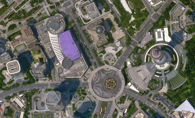
New possibilities
The city of Shanghai under the gaze of the satellite.
The list continues in
Chile
, where one is able to see the ice of
the San Quintín glacier
unfold
. Dubai does not escape the radar of Airbus, which, through the Pléiades Neo 3, dissects the tallest Ferris wheel in the world, the
Ain Dubai.
Even the
Capitol in Washington DC
has a place in this collection of images, the improvement of which will increase over the next few months, since they were acquired before the full radiometric calibrations, according to Airbus in a statement.
Not surprisingly, the photographs are expected to be commercially available in the
third quarter of 2021,
once these calibration steps are completed. With the full satellite capacity available for commercial use,
Pléiades Neo 3
offshoots will
provide analysts with a high level of detail, including
greater visibility
of small objects such as vehicles and road markings.
This
level of
object
detection,
recognition and identification provides more basic accuracy for image analysts.
The objective is to provide
greater precision in geolocation
and a deeper spectral band information, allowing more information to be obtained for different applications.
Dubai is also the subject of Airbus study.
In this sense, the Pléiades Neo constellation will be composed of four identical satellites, so that each of them adds half a million square kilometers per day with a
native resolution of 30 centimeters
.
The next milestone for the Pléiades Neo Program is the launch of
Pléiades Neo 4,
which is already in the Kourou launch center in French Guiana.
It is expected to launch this summer.
Then the 5 and 6 will come, but it will already be in 2022.
According to the criteria of The Trust Project
Know more
tourism
Airbus
Photography
LuxuryFive impressive hotel pools where bathing is the least important thing
The best cabins in the trees in Spain to sleep in the middle of nature
PyreneesThe Huesca zip line that aspires to be the fastest in the world: "The person who is going to break the record will go down without any kind of brake"
See links of interest
Work calendar
Home THE WORLD TODAY
Best Universities