
The beginning of the last week of February will be marked by frosty weather almost throughout the European part of Russia.
Forecasters predict that in some regions the night of February 23 may become the coldest since the beginning of winter.
According to the scientific director of the Hydrometeorological Center Roman Vilfand, on this day in a number of regions of the country the weather will be set with temperatures below normal by 15-16 ° C.
“February 23rd will be the most severe frosty day.
In the center of the European part of Russia - up to -35 ° C.
In the north of the European territory of Russia - up to -38 ° C.
Even in the south, temperatures are very low - -25 ...- 20 ° C.
In the Urals - up to -40 ° C, ”the source told RT.
Atmospheric pressure will begin to grow on the night of Monday, February 22: in the capital it will get colder to -15 ...- 13 ° С, during the day - to -13 ...- 11 ° С.
In the region - up to -25 ° С at night and up to -20 ° С during the day.
Then the pressure will continue to rise (up to almost 770 mm Hg), and in Moscow, a temperature drop to -27 ...- 25 ° C is expected, and in the daytime in sunny, low wind conditions, the air will warm up to -17 ...- 15 ° C.
The last time such frosts were recorded in the capital on 23 February was in 1956, when the temperature dropped to -27.1 ° C.
In the region, the temperature can drop to -33 ° С, during the day - up to -25 ° С, and forecasters report that in some parts of the capital region the next night will be extremely cold.
Forecasters also warn about freezing weather at the beginning of the week in Bashkiria, Nizhny Novgorod and Samara regions, Tatarstan, Udmurtia and other regions of the European part of Russia.
However, the weather anomaly will also be recorded in the rest of the country - "in fact to the Pacific coast," Roman Vilfand told RIA Novosti.
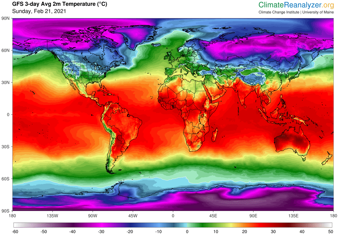
The University of Maine infographic below shows the average temperature forecast for February 24.
Areas in which the thermometer will drop below -25 ° C are colored purple.
Image via Climate Reanalyzer, Climate Change Institute, University of Maine, USA
Earlier, Tatyana Pozdnyakova, chief specialist of the Moscow Meteorological Bureau, said that in the period from February 20 to February 24, up to a quarter of the monthly norm of precipitation may fall in the city - a layer of fresh snow will reach 10-12 cm. Heavy precipitation is expected in St. Petersburg.
Thus, the chief forecaster of the city, Alexander Kolesov, told TASS that 20-25 mm of precipitation is expected by the beginning of the working week (65-80% of the monthly norm for February).
Already on Wednesday, February 24, atmospheric pressure in the European part of Russia will begin to fall, and the temperature will rise.
In the capital, thermometers will rise to -12 ...- 10 ° С, in the region - up to -20 ...- 10 ° С.
And by the end of the week, meteorologists expect that the air in the capital region will warm up to zero.
“A noticeable rise in temperature will begin.
In three days, if we talk about the center of European Russia, the temperature will rise by 25-30 ° C, "Vilfand told RT.
“On the morning of February 26, the temperature will tend to zero.
The very last days of February will be warm.
On February 27 and 28 the temperature will be 5-6 degrees above normal, ”he added.
At the same time, the expert urged not to associate this with the arrival of a climatic spring.
According to him, there will still be a cold snap: "Spring will not come so quickly and easily."
In mid-February, many regions of Russia, from Crimea to Sakhalin, were in the grip of heavy snowfalls.
In the south-west of the country, traffic on the bridge across the Kerch Strait was completely blocked for several hours, in Moscow the record for the height of snow cover was practically broken (it reached 59 cm), and the Far East was in the zone of action of a very deep southern cyclone.
At the same time, heavy snowfalls covered much of the southern United States, including Texas, Arizona, Alabama, Mississippi and Louisiana.
At the same time, record low temperatures were recorded in more northern states.
President Joe Biden even had to declare Texas a natural disaster zone.
Severe cold weather, accompanied by a series of Atlantic storms, affected Europe and the Middle East.
Snow covered many Mediterranean countries, including Spain and Greece, and even fell in Saudi Arabia.
In more northern countries, severe cold was noted, for example, in the Netherlands, canals froze - this is a relatively rare event.
According to the World Meteorological Organization (WMO), February's extreme weather conditions in the Northern Hemisphere were caused by a phenomenon called sudden stratospheric warming.
Experts explain that a strong increase in atmospheric temperature at an altitude of about 30 km above the North Pole has led to a weakening of the polar vortex, which usually keeps the coldest air in the Arctic during the winter.
This is what allowed cold air to penetrate into the middle latitudes, and warmer air to rise to the Arctic.
WMO has compiled a roundup of the extreme weather impacting USA and parts of Europe this month.
Details https://t.co/hODMz1NKAqpic.twitter.com/8pJ5FRobDW
- World Meteorological Organization (@WMO) February 19, 2021