
Tenerife. Route 040, this is the path with the most unevenness in Spain
Nature.The Sierra de las Nieves, the new Spanish national park
It was already known.
Before the day it exploded, the seismic tremors became the minute hand that marked the lives of the islanders in endless days of anxiety and fear.
Just in the previous 24 hours, there were more than a
thousand shocks, a
true seismic swarm that had its brutal epilogue on
October 26, 1971.
It was then that at the southern tip of the Canary Island of La Palma, the
Teneguía volcano
erupted.
.
Admired and on high alert, the world witnessed an eruptive process described as fascinating for 23 days.
Little time for the years that other eruptions have lasted on these same islands.
This year marks half a century since that
volcanic explosion,
the penultimate to occur in Spanish territory.
The last one happened in 2011, also in the Canary Islands.
It was south of El Hierro, on the
Tagoro volcano,
although it never emerged from the waters (it occurred at a depth of 400 meters).
CHAOS OF FAULTS, CONES AND CRATERS
Sulfuric gases, stones and lava, incandescent materials, the earth shaking and an unmistakable smell were the constant of those days fifty years ago.
The chaos of the interior of the planet made its way through the
six mouths
that broke the ground of the southern tip of the Isla Bonita, to vomit
magma
, which with the most unstoppable slowness, descended towards the Atlantic at 120 meters per hour.
The paths of this natural space run between solidified lava flows.
After that, with the earth still burning the soles of the shoes, the Teneguía fell, but the horizon had already changed completely.
The volcano materialized in its unmistakable reddish cone, which reaches 439 meters in height less than a kilometer in a straight line from the coastline.
Around them, a chaos of chimneys, clumps, faults, cones and craters, which lose height as they approach the ocean.
The rivers of lava advanced until its waters, overflowing the old coastal cliff and accumulating on the seabed.
The magnitude of those materials made them emerge from the ocean, gaining ground from its waters.
As they solidified, they formed a
platform known as the low island,
which stretched the island beyond its southern tip, adding some
two million square meters
to Palma's territory.
Important tourist claim
Despite the spectacular nature of the eruptions, they did not cause any casualties, nor did they affect the surrounding populations, some of them extremely close to the volcanic apparatus.
They did destroy different crops and one of the
best beaches
on the southern tip of Palma.
In return, the land gave away a portion of land that is the youngest in the territory of our country and, still without finishing roaring, the Teneguía became the best tourist attraction on La Palma.
It has not stopped being.
Post in the protected natural area.
Attracted by the telluric force of the volcano, in those distant days of October 1971, hundreds of people arrived on the island;
studious, curious and simple tourists, eager to see with their own eyes the
spectacle of the fire
that arose from the interior of the earth.
The time that has passed has not diluted the charm of this small mountain of fire and every season, even under the pandemic that we suffer, tourists do not stop coming to his call.
Most are content to look at the
viewpoint of the San Antonio volcano
and stroll around the Fuencaliente Visitor Center, where the world of volcanic eruptions in the Canaries is explained.
Others travel any of the trails that pass through the volcanic space.
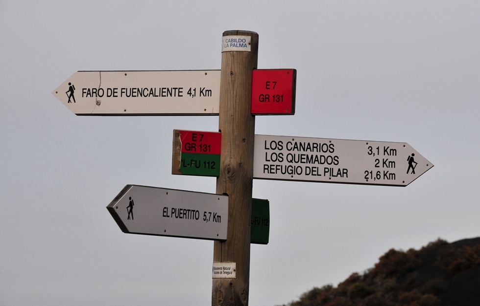
The work of the authorities of La Palma is excellent and signs and maintains the roads of the place, not in vain the Canary Island is considered one of the best places in the world for
trekking
.
The highest point of the Teneguía, 439 meters above the sea.
Marked with signs and signposts of directions and distances, all have handrails in the most delicate steps.
The busiest are those that climb to the peaks of Teneguía and San Antonio.
The
GR131 path
is one of the most recommended, with seven kilometers in each direction, it connects the Visitor Center with the Fuencaliente Lighthouse.
The normal time to travel it is around four hours, round trip.
Natural Monument
In 1987 Teneguía and its surroundings were declared a Natural Monument of the Teneguía Volcanoes.
At present the Cumbre Vieja Natural Park is segregated from its neighbor.
Added to its geological importance is its status as a laboratory of island biodiversity.
Although the volcano has been sleeping for fifty years, it is true that if you dig into the ground it is still warm.
You can already see the caress of the wind in the edges and profiles of the rocks.
It is a desert landscape, but at the bottom of the cones, the slopes of the volcanic devices and throughout the badlands, a plant community clings to the cracks with the constancy that life gives.
The formidable Canarian pines colonize the slippery slopes and at their feet, defying the winds and the almost absolute dryness, a crawling universe of bushes and flowers thrives.
Before the pandemic, the flow of visitors increased year after year, to the point of arousing the concern of the Fuencaliente authorities.
The excessive traffic of tourists wears the roads, suffers a vegetation that has half a hundred endemic species, birds such as hawks are scared away.
Hikers on a route of the Natural Monument of the Volcanoes of Teneguía.
Worrying issue, although it is nothing new.
Visitor pressure forced the Cabildo de La Palma to enact a law in 1989 that prohibits the collection of stones and any other natural object in the Teneguía area, under a fine of between 60 and 60,000 euros.
Practical Guide
Where to eat
The Jardín de la Sal, next to the lighthouse and the salt flats of Fuencaliente, offers local fish, such as the school or the sable.
Where to sleep
In the municipality of Fuencaliente, very close to the Teneguía protected area and next to the coast, La Palma & Teneguía Princess is one of the best resort hotels on Isla Bonita.
An interesting set of gardens and swimming pools with a well-cared spa area.
More information
at www.lapalmabiosfera.es
According to the criteria of The Trust Project
Know more
Spain
Canary Islands
tourism
Plans48 hours of disconnection in Tenerife
TourismThe great crater of tourism: 72,000 million euros less in the worst year in history
Valentine's Day Sweetheart, Coitos or Fights: these are eight towns in Spain for a couple's route
See links of interest
Work calendar
Quique San Francisco