
Last minute - all about the storm
Temporary: the day it did not get dark in Madrid
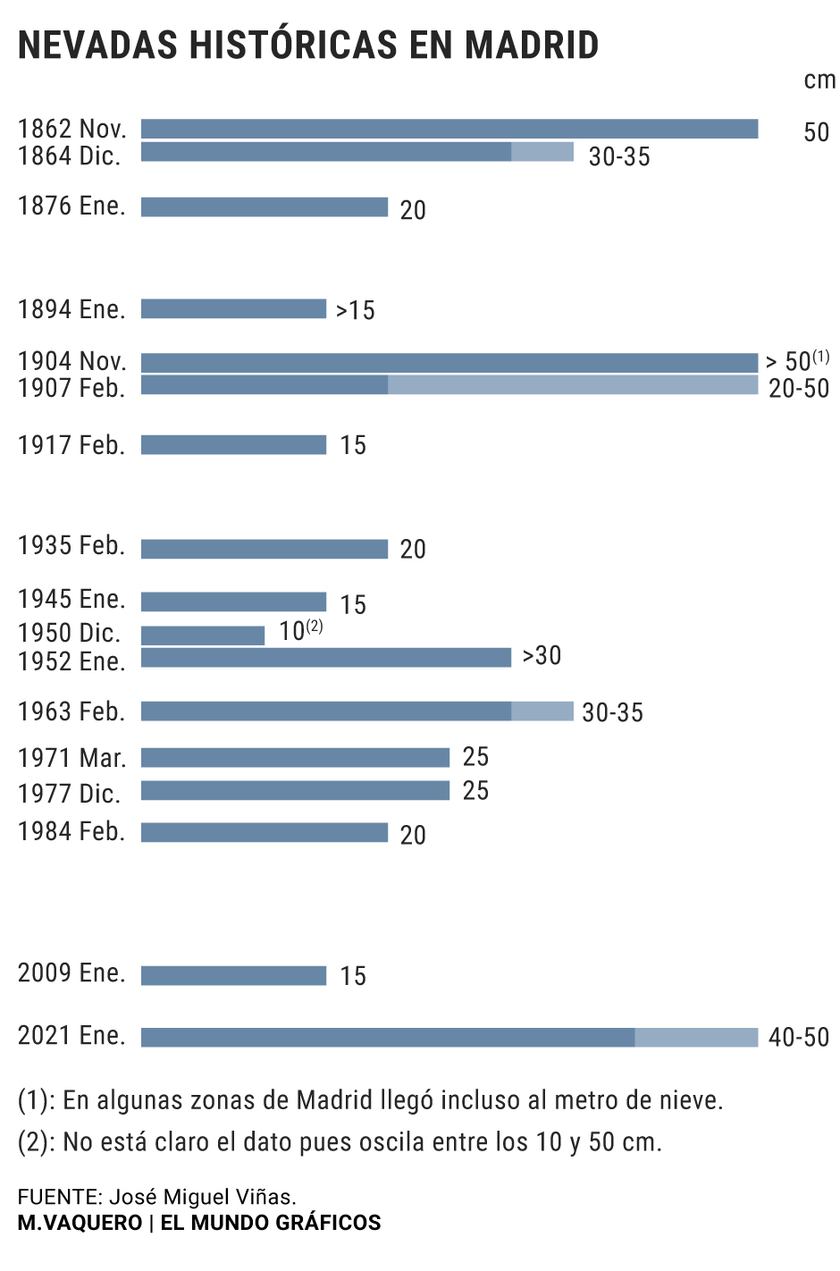
Like every time something exceptional happens, the great snowfall that has paralyzed Madrid has made us go back in time to look for antecedents.
For almost 50 years not so much snow has fallen in the capital, because as the State Meteorological Agency (AEMET) has recalled, it
is necessary to go back to March 1971 to find a situation comparable
to that of these days.
From noon on Friday, when it began, until 6:00 p.m. on Saturday, when it stopped after 30 hours of incessant snow fall, the central Madrid station of Retiro registered 50.5 liters per square meter, much more than the total rainfall that they fall on average in a normal January (33 liters per square meter).
We are in awe, and rightly so.
But although these large snowfalls have never been common in the capital, they did occur much more frequently during the last century.
There are no more witnesses than the newspaper archives, but
on November 27, 1904, the greatest snowfall on record began in Madrid
, both for its duration (about 32 hours) and for the amount that fell.
The magazine 'The Spanish and American Illustration' and the weekly 'Nuevo Mundo' published impressive images of the El Retiro park covered in snow or a panoramic view of the capital dyed in white taken from the tower of the Church of Santa Cruz.
As José Miguel Viñas, Meteored meteorologist at
www.tiempo.com
,
recalls
, from November 27 to 30, 1904 a layer of snow accumulated that, according to the neighborhoods, ranged from 70 centimeters to one meter thick.
The city was also paralyzed then: trains, trams or cars stopped running and communications were interrupted when the telegraph lines fell.
"The roads are almost lonely, many shops are closed, the cafes are not crowded, the theatrical performances were suspended yesterday, the telephone communication was interrupted, most of the residents locked in their homes ... Madrid begins the last month of the year like a dead town and buried under immense blocks of marble ", narrated 'El Imparcial' on December 1, 1904.
On February 6, 1907, Viñas adds, a good snowfall also fell in the capital, but
the most similar to this year is probably February 1963
: "It snowed for three days and accumulated between 30 and 35 centimeters of snow , somewhat less than these days. "
Let's go back to 1904 again. As has happened now, that snowstorm that sowed chaos in Madrid was "bookish", according to the meteorologist.
In 1904 a deep Atlantic storm came together from Madeira with cold air of polar origin that had settled in the Iberian peninsula in the previous days, a situation similar to that which has occurred now.
"For this big snowfall to form and stay, we needed cold. At the end of December and the beginning of January there were temperatures below normal. The thermometers began to drop due to the entry of a very cold polar air mass. , which caused that on Thursday some records were broken in pending mountain stations to be confirmed (-38.4º C in the Leon town of Vega de Liordes, in Picos de Europa, and -34.1ºC in Clot del Tuc de la Llança, in the Lleida Pyrenees) .On the other hand, we had a polar trough to the west of the Peninsula, that is, an ascent of masses of warm and humid air along an elongated zone of low atmospheric pressure that is located in two regions of greater pressure. And in third place, we had Filomena, the storm that has contributed the humidity.
On the night of Friday to Saturday the ideal confluence for this historic snowfall occurred
", explains Mar Gómez, head of the meteorology network of
www.eltiempo.es
.
"It had not happened for a long time that these ingredients were given at the same time, a north polar air mass with a storm that brings a lot of rainfall, for this phenomenon to occur that causes these heavy snowfalls," says Fernado Belda, spokesperson for the AEMET, which highlights the accurate weather forecast that for several days allowed meteorologists to launch the alert.
"Everyone was warned"
"In this case, both the physical-mathematical models and the human factor have worked well, which is the one who launches the prediction after analyzing them and informs Civil Protection, which has insisted a lot to warn the population and to avoid displacement. the world was warned but there have been those who have paid attention and people who have not, "he says.
The models were right, but did they really expect so much snow ?: "There has never been a red alert level in the central and southern areas of Madrid so far in advance, which means that this situation had already been reported days ago. Then they can be 20, 25 or 40 the centimeters of snow that there is, "he adds.
The AEMET confirmed yesterday that after the passage of the storm Filomena, the snowfalls will cease in most of the interior but
a cold wave awaits us that will bring night temperatures below -10 degrees
in the interior of the peninsula, and maximums that they will not exceed zero degrees.
An intense cold that will probably accompany us until Friday and that will coincide with large masses of ice on the ground, in the trees and on the roofs.
"We are going to have a big problem because there will be brutal frosts in the next few days. The snow is going to turn into ice because during the day it will be around zero degrees, so
even if there is sun, the ice will persist
and you can break cold records in Madrid and Castilla-La Mancha ", warns José Antonio Maldonado, Meteored's Director of Meteorology, who by the way, saw the snow for the first time on the night of February 2 to 3, 1954 at his home in Seville : "I was nine years old and it curdled a lot, although it did not last long. My mother took me out of bed so that I could see the snow," says the meteorologist, recalling this unusual snowfall that reached the Costa del Sol.
"
The worst of this snowfall is yet to come due to the cold
. There are already a number of tree branches on the ground and some awnings are falling. Due to the weight of the snow, some structures may give way," warns Maldonado.
"The most dangerous thing after the snowfall is that there is enough humidity and there is ice.
We will be around -3ºC or -4ºC with temperature drops of -10 or -11ºC
. There is a lot of risk of pedestrian slips and for traffic The branches break and it will not only affect the trees, but also the crops. There are days when you have to be very careful both in the countryside and in the city. There will be a great impact in the coming days. " , agrees Fernando Belda.
"The best thing is not to move and go out only if it is essential.
The ice is very dangerous because of the falls and you have to stay away from the trees,
" warns Mar Gómez.
Year of records
This major snowstorm started just the day that the European Climate Change Service Corpernicus reported that
2020 has equaled 2016 as the warmest year globally
since there are records, and confirmed a fact that was already expected: that the past decade It has been the hottest.
2020 has also been a record year for the number of extreme events.
There have been 30 named tropical storms in the Atlantic (versus the annual average of 12) and record-breaking high temperatures in many places on the planet.
Only in Spain last year there were 13 storms of great impact and a great heat wave.
"The trend is very clear, we are heading towards warming. 2020 has tied with 2016 as the warmest year and the forecast for 2021 is that it will also be warm, although not as warm as 2020. We must have a global perspective, that we have Having this situation does not mean that we are going to have a very cold year, "says José Miguel Viñas.
The models with which they work, he adds, "suggest that there will be more and more extreme phenomena, and although this extreme weather will translate mainly into more hurricanes and more frequent heat waves, phenomena such as this great snowfall may occur from time to time. ".
José Antonio Maldonado believes "that the situation we are experiencing has nothing to do with climate change, which does not mean that the general trend is not rising temperatures."
"Climate change exists, is already happening and will continue in the coming years regardless of extreme events.
In Spain the trend is for temperatures to continue increasing
, which does not imply that there will not be specific episodes of very cold In fact, globally, the high temperatures caused by climate change can produce changes in the dynamics of the atmosphere and modify the jet stream, in our case the polar jet stream. This would allow colder air to enter from the polar regions and in summer, the entry of air masses that generate more heat ", says Mar Gómez.
"Phenomena that apparently have no link can be related, and the models argue that extreme weather events are going to be accentuated."
According to the criteria of The Trust Project
Know more
Madrid
Spain
Climate change
Temporary FilomenaThe biggest snowfall in half a century paralyzes half of Spain
MusicSantos Bacana, the man from Madrid behind El Madrileño by C. Tangana
Economic NewsIsidro Fainé, the man behind the 'superbank': "We must mentalize ourselves for a period of difficulties of uncertain duration"
See links of interest
Coronavirus
Check Child Lottery
Seville - Real Sociedad
Benevento - Atalanta
Mirandés - Rayo Vallecano
Granada CF - Barcelona
Osasuna - Real Madrid