
Typhoon "Shader" is approaching Hainan to create wind and rain
China Weather News. In the next three days, most of the central and eastern parts of my country will be mainly sunny, but affected by the typhoon "Shader", today (October 24), Hainan ushered in the strongest rainfall period, and some areas will experience heavy rain .
In terms of temperature, this weekend, the temperature in most parts of the north rose, and the highest temperature in North China and other places rose to about 20 degrees Celsius. The warmth was obvious.
Typhoon "Shader" will wipe Hainan and bring strong winds and rain, and the rainy areas of Sichuan and Chongqing will return again
In the next three days, the scope of rain and snow in my country will not be large, and most of the central and eastern regions will be dominated by fine weather. Among them, the heavy rainfall today is mainly concentrated in Hainan to Leizhou Peninsula and northwestern Yunnan. Tomorrow, the rain will continue to be strong in parts of Hainan Island. Large-scale rainy weather in Sichuan and Chongqing is "online" again.
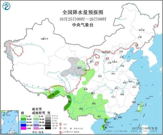
The Central Meteorological Observatory predicts that today, there will be light to moderate snow or sleet in parts of high-altitude areas in northern Xinjiang, eastern Qinghai, northeastern Tibet, and eastern Heilongjiang.
There were moderate to heavy rains in parts of southeastern Tibet, northwestern Yunnan, and most of Hainan Island. Among them, there were heavy rains in eastern and southern parts of Hainan, and local heavy rains.
Tomorrow, there will be light snow or sleet in parts of the western mountainous areas of southern Xinjiang, eastern Qinghai, and central and southern Gansu.
There was light to moderate rain in parts of southeastern Tibet, the east and south of southwestern China, southwestern China, and most of Taiwan Island. Among them, there was heavy rain (25-40 mm) in the central and eastern parts of Hainan Island.
There are 4-6 winds in parts of western and central Inner Mongolia, northeastern northwestern China, eastern Heilongjiang, central Tibet, and southeastern Guangxi coastal areas.
The day after tomorrow, there will be light to moderate snow or sleet in parts of northeastern Inner Mongolia, northwest Heilongjiang, Xinjiang Southern Xinjiang Basin, northwest Tibet, and central and eastern northwestern regions.
There was light to moderate rain in parts of eastern Northeast China, southeastern Tibet, most of Southwest China, western South China, Hainan Island, Taiwan Island and other places. Among them, there was heavy rain in central Hainan Island.
The center of this year’s No. 17 typhoon "Shader" is located at 5 o'clock in the morning in the middle of the South China Sea, about 170 kilometers northeast of Yongxing Island in Xisha, Hainan. The intensity is gradually weakening, and it will pass through the southern part of Hainan Island from today night to tomorrow morning. , Tending to the north-central coast of Vietnam.
Affected by this, some sea areas such as the South China coast and the South China Sea have strong winds, and some areas of Hainan Island and other places have moderate to heavy rains. Among them, there are heavy rains in eastern and southern parts of Hainan, and heavy local heavy rains.
In the city, Sanya has experienced a lot of rainfall in mid-October, and the rainfall will continue to be frequent in the next week. The local area needs to pay attention to preventing secondary disasters that may be caused by continuous heavy rainfall.
A new wave of cold air ensued in Xinjiang to cool down violently. Temperatures in most northern parts of the country fluctuated over the weekend
Yesterday, cold air cooled most areas in my country. As of 08:00 on October 23, Harbin, Changchun, Shenyang, Hohhot, Taiyuan, Beijing, Tianjin, Shijiazhuang, Jinan, Zhengzhou, Hefei, Wuhan, Nanjing, Shanghai, Hangzhou The lowest temperatures in 18 provincial-level cities such as Chongqing, Lhasa, and Fuzhou hit a record low in the second half of this year.
Yesterday, after the cold air passed, the sky in Beijing was blue and autumn was full.
(Photo/Wang Xiao)
The last cold air just left, a new cold air left Xinjiang again last night, and the local temperature dropped violently.
It is expected that in the next three days, affected by the medium-intensity cold air, the average temperature in parts of northern Xinjiang, most of Inner Mongolia, most of North China, and Northeast China will drop by 4 to 6°C.
This cold air will take the lead in Xinjiang for two days. The highest temperature in Urumqi, the capital today, is only 6°C, which is the lowest day of the highest temperature since this autumn. It is expected that the cold air will gradually move eastward from October 25 to 27 and affect the northern regions. .
However, before the arrival of the cold air, the temperature in the north will rise sharply. Around October 25, the highest temperature in North China and other places will rise again to above 20℃, and the northeast region will also rise to about 15℃.
With the entry of cold air in the later period, the temperature in most of the north will drop rapidly.
In general, the temperature in most northern regions will fluctuate significantly in the coming week, and the public needs to adjust clothing in time according to temperature changes.