
China Weather News from today (October 9), a new wave of cold air will gradually affect most of the north, and the local temperature in North China, Northeast, Huanghuai and other places can reach about 8 ℃.
At the beginning of next week, most of the north will refresh the lowest temperature since the second half of this year.
In terms of precipitation, the reduction of precipitation in my country will weaken in the next three days, mainly light rain.
Yesterday entered the cold dew solar term, and the cold air is still affecting parts of the north, the eastern part of the northwestern region and other places have cooled down, and the temperature in the western part of Inner Mongolia has dropped by 6-8°C, and the local temperature is 10-12°C.
From the 9th to the 12th, a new and more powerful cold air will affect most of the areas north of the Yangtze River. The northwest, north China, northeast, Huanghuai and other places will generally cool 4-6℃, and the local area will be about 8℃. Accompanied by 4-5 winds and gusts 6-7.
Under the frequent influence of cold air, next week, most parts of the north will gradually refresh the lowest temperature since the second half of this year. The highest temperature will drop below 20℃ again, and some places in the northeast and northwest will even be less than 10℃. At the same time, the lowest temperature will be 0℃. Will press south to the north of North China.
For example, in Changchun, the highest temperature was only 8°C on the 14th, which will drop below 10°C for the first time in the second half of this year. Taiyuan, Harbin and other places will experience the cold below freezing for the first time.
During the intermittent period of cold air, atmospheric diffusion conditions in North China and other places are normal. It is expected that some areas of central and southern North China will have mild haze today and tomorrow, and local moderate haze.
From night to morning from the 10th to the 11th, there will be heavy fog in parts of southern Beijing, central Hebei and other places, and there will be dense fog with a visibility of less than 500 meters.
From daytime on the 11th, with the arrival of cold air, atmospheric diffusion conditions improve, and the fog and haze will gradually dissipate.
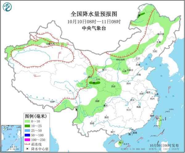
In terms of precipitation, the reduction of precipitation in my country will weaken in the next three days, mainly light rain.
The Central Meteorological Observatory predicts that today there will be light to moderate rain in parts of western and northern Xinjiang, eastern Inner Mongolia, central and northern Northeast China, central and eastern Northwest China, most of southwestern China, northern Yunnan, eastern Tibet, Hainan Island, and Taiwan Island. There were heavy rains locally in northern Yunnan and southern Sichuan.
Tomorrow, there will be light rain in parts of Xinjiang along the Tianshan Mountains, central and eastern Inner Mongolia, central and northern Heilongjiang, central and eastern Northwest China, northern and western North China, southeastern Tibet, and northeastern southwestern regions, and local moderate rain.
On the 11th, there were light rains in the mountainous areas of western southern Xinjiang, eastern northeastern regions, central-eastern northwestern regions, western and southern northern China, southeastern Tibet, northern Huanghuai, western Jianghan, and most of southwestern regions.
It is worth noting that since the beginning of the autumn rains in West China on September 9, the number of rainy days in the central and southern areas of West China has generally exceeded 20 days, and the areas in central Sichuan and southeastern Chongqing have even reached or exceeded 25 days, which are significantly more than normal. .
In the next few days, there will be continuous autumn rains in West China. Although the magnitude is not large, it is difficult to clear. The public should pay attention to the adverse effects of continuous rainy weather.
In addition, this year’s 14th typhoon "Canhong" is located on the Northwest Pacific Ocean about 345 kilometers south of Kochi Prefecture at 5 o'clock this morning.
It is predicted that "Canhong" will move to the northeast at a speed of about 10 kilometers per hour. The speed of movement will increase and the intensity will gradually weaken. It will transform into an extratropical cyclone after moving into the east of Japan.
Affected by "Canhong", during the day on the 9th, there will be strong winds of magnitude 7-8 and gusts of magnitude 9-10 in the eastern part of the East China Sea. Take precautions.