
Typhoon Hagupit is expected to land in Zhejiang and Fujian tonight, and
there will be torrential rain to heavy rain in the coastal areas of southeastern Zhejiang; the National Defense Agency initiates emergency response to flood prevention and typhoon level IV
According to the Central Meteorological Observatory, the fourth typhoon "Hagupit" this year will make landfall over the coast from southern Zhejiang to northern Fujian this evening. Affected by this, from the night of the 3rd to the 4th, there were moderate to heavy rains in the northeastern coast of Fujian, the central and eastern Zhejiang, and the southeast of Jiangsu, and there were heavy to heavy rains in the coastal areas of southeast Zhejiang.
The Beijing News reported on August 2, the Central Meteorological Observatory announced that typhoon "Sen Lak" weakened into a tropical depression at 17:00 on the 2nd in Thanh Hoa City, Vietnam. Its wind weakened further and it was difficult to determine its circulation center. It stopped numbering at 17:00 on the 2nd.
Another typhoon "Hagubi", which was generated on the same day as "Senrak", was heading to the coast of Zhejiang and Fujian. The typhoon warning was issued at 18:00 on the 2nd. It is expected that "Hagupit" will land on the coast from southern Zhejiang to northern Fujian on the night of the 3rd.
"Hagupit" will quickly weaken after landing
As soon as August entered, the typhoon became active. On August 1, typhoons "Senrak" and "Hagupit" were generated one after another, breaking the "empty platform" situation that had been maintained for more than a month; the generation of typhoons in the first seven months of 2020 was achieved in just one day.
The center of this year’s No. 4 typhoon "Hagupit" (tropical storm level) was located at 17:00 on the 2nd on the northwest Pacific ocean about 600 kilometers southeast of Cangnan County, Zhejiang Province. The maximum wind force near the center was 8 (20 m/s). , The lowest pressure in the center is 995 hPa.
The Central Meteorological Observatory predicts that "Hagupit" will land on the coast from southern Zhejiang to northern Fujian on the night of the 3rd (tropical storm level, 8-9 level, 20-23 m/s). After landing, the intensity quickly weakened.
The strong wind forecast shows that from 20: 00 on August 2 to 20: 00 on August 3, there will be 6-7 strong winds in the east of Taiwan, most of the East China Sea and the waters near the Diaoyu Islands, the coast of Zhejiang, the northern coast of Fujian, and the northern coast of Taiwan Island. The nearby sea area passing by the center of "Gebi" can reach wind force 10 and gust 12.
The precipitation forecast shows that from 20: 00 on August 2 to 20: 00 on the 3rd, there will be heavy rain in the northern part of Taiwan Island, and heavy rain (100-120 mm) locally.
Meteorological experts said that "Hagupit" is currently on the rise and it is expected to reach the level of a strong tropical storm at its peak. It should be noted that the possibility of strengthening is not ruled out in the future, and the meteorological department will continue to pay attention.
Rainfall in Southern China After Suspension of "Senrak"
This year’s No. 3 typhoon "Sen Lak" was generated at 14:00 on August 1, and passed over the southern sea of Sanya, Hainan around 15:00, moved into the Beibu Gulf at 17:00, and was on the coast near Thanh Hoa City, Vietnam at around 14:40 on the 2nd. Log in. At 17:00 on the 2nd, "Senrak" weakened into a tropical depression in Thanh Hoa City, Vietnam. Its wind weakened further and it was difficult to determine its circulation center. The Central Meteorological Observatory stopped numbering it at 17:00 on the 2nd.
Although "Senrak" has gone far, there are still continuous rains in southern China. Behind this, the monsoon is "indispensable."
It is expected that from the 2nd to the 6th, under the combined influence of "Senrak" and the monsoon, there will be heavy rain or heavy rain in Guangdong, Guangxi, Hainan Island, southern Fujian and other places. There will be heavy rains locally, and the main rainfall will appear on the 4th to 6th; southern Guangdong , Southern Guangxi and other places have accumulated rainfall of 200 to 300 mm, and the local area can reach more than 400 mm. The maximum hourly rainfall is 40 to 70 mm and the local area is more than 80 mm.
Monitoring shows that under the “moisture” of rainfall, the “heat” in eastern Guangdong and northern Hainan Island has been weakened a lot, and the meteorological drought has also improved.
■ Response
The Ministry of National Defense and the Ministry of Emergency Management have sent a working group to Zhejiang
At 12 o'clock on August 2, in accordance with the "National Emergency Plan for Flood Control and Drought Relief" and relevant regulations, the State General Administration of Defense decided to initiate a level IV emergency response for flood control and typhoon prevention. The National Defense General stated that "Hagupit" is expected to land on the coast from central Zhejiang to northern Fujian on the night of the 3rd. Affected by this, from the night of the 3rd to the 4th, there were moderate to heavy rains in the northeastern coast of Fujian, the central and eastern Zhejiang, and the southeast of Jiangsu, and there were heavy to heavy rains in the coastal areas of southeast Zhejiang.
Zhejiang Province initiated the Typhoon Type IV emergency response at 12:00 on August 2. According to the requirements of Zhejiang Province’s anti-fingerprint control system, the “Hagupit” wind and rainfall periods are concentrated (mainly from the afternoon of the 3rd to the morning of the 4th), and coincides with the astronomical climax period of June in the lunar calendar. Wenzhou, Lishui, Taizhou, Ningbo, etc. Coastal areas must conscientiously organize consultations to study and judge the possible impacts and risks of "Hagupit", consider the worst, and conscientiously organize various tasks for typhoon defense.
At 5 pm on the 2nd, Fujian Province upgraded its typhoon emergency response to level III.
In addition, the Ministry of National Defense and the Ministry of Emergency Management have sent a working group to Zhejiang Province to assist in guiding typhoon defense work.
Meteorological experts reminded that passing ships and marine operators in the relevant waters of Zhejiang, Fujian and other places should return to the port for shelter in time, and safety management should be done for island tourism and water projects. Guangdong, Guangxi, Hainan, southern Fujian and other places need to guard against secondary disasters such as urban and rural waterlogging, mountain floods, and landslides that may be caused by continuous heavy rainfall.
■ Data analysis
August or typhoon storm
In the first half of this year, there were only two typhoons in the Northwest Pacific and the South China Sea, which were less than normal in the same period. Then there was the first "empty July" (no typhoon in July) since 1949, and typhoon activity was not active.
The medium-term forecast shows that the typhoon may not enter the active period immediately in early August. It is estimated that in mid-August, with the adjustment of the atmospheric circulation, there may be another tropical cyclone. It is not ruled out that it may usher in late August. The active period of a typhoon.
Statistics show that August is the month with the most frequent typhoon activities, with an average of 5.7 typhoons generated in history, of which 1960 and 1966 (10) were the most generated.
According to climate forecasts, there will be 4-6 typhoons in the Northwest Pacific and South China Sea in August this year, of which 1-2 will affect my country.
Nearly 6 typhoons were generated in August every year in 1971
Statistics show that from 1949 to 2019, 403 typhoons were generated in August in the Northwest Pacific and the South China Sea. On average, nearly 6 typhoons were generated in August each year, that is, 1 typhoon was generated every 5 days. In addition, the average life history of a typhoon is about 148 hours (about 6 days), so August may usually be one typhoon after one typhoon, and it is easy for multiple typhoons to dance together.
There was a situation of "five dances" in August 1960. On August 23 of that year, Typhoon No. 14 "Carmen", Typhoon No. 15 "Beth", Typhoon No. 16 "Irene", Typhoon No. 17 " "Della" and Typhoon No. 18 "Fei" coexist in this sea area.
Few typhoons in August in the past ten years
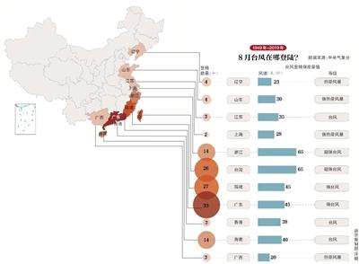
Since 1949, a total of 403 typhoons have been generated in the Northwest Pacific and the South China Sea in August, of which 133 have landed in my country, accounting for 33% of them. The most generated typhoons were in 1960 and 1966. In these two years, there were 10 typhoons in August, but only 1 typhoon was generated in August in 2014.
In August, the average number of typhoons landed in my country was about 1.9. In the three years of 1994, 1995, and 2012, the number of typhoons landed in August could reach as many as 5, and one typhoon landed in 6 days on average.
In the 70 years since the 1950s, the 10-year average number of typhoons generated (landed) in August were 5.6 (1.4), 7 (2), 5.4 (1.9), 5.3 (1.2), 6.1 (2.5), 5.7 ( 2.2) and 4.9 (2.1), of which the number of typhoons generated in the 10 years from 2010 to 2019 was the least, but the number of landings did not decrease.
Beijing News reporter Deng Qi and Li Yukun