
Forecasters predict a new wave of Arctic air in the metropolitan area. The Hydrometeorological Center said that the thermometer columns may drop by 10 ° C relative to the weekend.
As the director of the Hydrometeorological Center of Russia Roman Vilfand said in an interview with RT, there is a sharp change in the circulation of the atmosphere, air flows rush to the center of European Russia from the north. According to the weather forecaster, we are talking about a real cooling.
“On Tuesday, the temperature is about +20 ° C maximum. Of course, after a 29-degree temperature, this drop. On Wednesday and Thursday, the temperature will be even lower, + 14 ... + 19 ° С. This will cause a great feeling of discomfort, because it is a real cooling, ”said Wilfand.
The weather forecaster stressed that along with a sharp change in temperature there will be a significant change in weather conditions.
“The pressure drops, and the weather will be: cloudy and rainy. Weather changes will be felt from Monday, but especially from Tuesday. On Wednesday there will be very noticeable rains, and in places it will rain heavily, ”Wilfand continued.
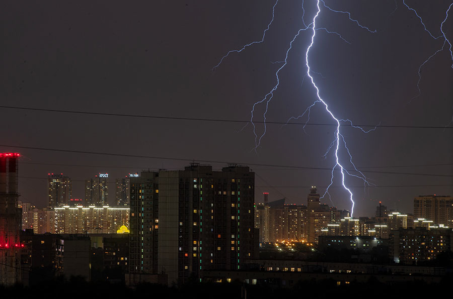
He indicated that these rains would be monotonous and not like summer short rainfall. Along with this, the expert said, thunderstorms are expected.
“Then there will be just thunderstorms, but, of course, with interruptions, but still it will be gloomy, there will be low gloomy clouds - the northern sky,” said the scientific director of the Hydrometeorological Center.
- RIA News
- © Maxim Blinov
He also warned of gusts of wind. Average values will reach 7-8 m / s, but there will periodically be gusts of up to 17-20 m / s.
“There will be a period of uncomfortable weather, which will end at the end of the working week, on Friday it will be slightly better, and by the weekend the weather will improve,” the expert said.
The chief specialist of the Moscow Weather Bureau Tatyana Pozdnyakova agreed with the statement about the upcoming cooling. At the same time, she adheres to more restrained estimates of temperature values.
“Today, night and tomorrow, we will be in the zone of the cold front, beyond which we will really receive cooler air. First of all, this will affect the daytime temperature, because it will rain, there will be evaporation, and therefore in the middle of the week, when we are in the rear of this cold front, as if behind it, the air temperature will really drop, ”RT Pozdnyakova said.
According to her, on Monday the daily temperature will be + 25 ... + 27 ° С, on Tuesday the values will drop to + 21 ... + 23 ° С, and on Wednesday it is expected + 20 ... + 22 ° С.
“I can’t say that this is a strong cooling, this is really a drop in temperature. If now we have somewhere the temperature is higher than the climatic norm, then later it may be slightly lower than the climatic norm. We already observed such processes in July, ”believes Pozdnyakova.
She noted that the waves of hot and cold weather this month alternate in two to three days. However, she pointed out that the current values of thermometers can be considered an excess of the climatic norm.
“In the last days, yesterday and today, the temperature is higher than the climatic norm, a little, but still higher. Although it must be said that the elevation of +30 ° C in the Central region reached only certain areas of the Voronezh region. In the metropolitan region, it was approaching +30 ° C, but did not exceed this mark, ”the expert concluded.
Note that in a number of Russian regions abnormally hot weather is observed. Only in the last week at least two temperature records have been established in the cities of the Russian Federation.
So, in Kazan on July 8, at the Kazan-Opornaya weather station, the maximum air temperature reached +34.4 ° C, at the Kazan-Airport aviation weather station - +34.6 ° C, at the Kazan-Sokol aviation weather station - + 35.7 ˚С. The previous record was recorded in 1954. Then the air warmed up to +33.3 ° C.
The indicators of 1954 were also surpassed in Kirov, where on July 8 the maximum air temperature was +34 ° С. The previous maximum temperature was +32.9 ° C (1954).
Altai authorities have introduced an emergency regime in the region in 59 districts and two urban districts due to drought. In addition, earlier in a number of cities in the Krasnodar Territory, water supply was introduced on schedule.
Over the coming week, abnormal heat is expected in the Perm region. Forecasters say that by the beginning of next week, the thermometer columns can rise to +36 ° C.