
- Summer Holidays in town and beaches without foreigners: the future of Spanish tourism
- Paradises: quarantines in idyllic places: from Neymar's mansion to a honeymoon in Maldives
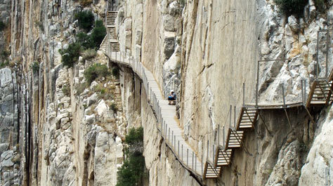
When it was built in 1921, it was considered a feat of engineering to the point of receiving the name of "the most dangerous path in the world" . We are talking about the Caminito del Rey, the one that crosses the impressive Desfiladero de los Gaitanes , which reaches a depth of up to 700 meters at some points, while others is not even one wide.
Located on the border between the Malaga municipalities of Álora, Antequera and Ardales, with time and abandonment, the trail fell into decline, forcing its closure. It was not until 2015 that it was reopened to the public via a 7.7 kilometer hiking route that runs along wooden walkways . On the occasion of the fifth anniversary, a 360-degree virtual tour has been devised at caminitodelrey.info.es/tour360, the best way to enjoy it from home after its closure during confinement.
A suspension bridge 105 meters high
The online itinerary covers 40 points of interest with videos and images, including the jewel in the crown: the suspension bridge suspended at a height of 105 meters . Among the other landmarks, the glass balcony, the water viaduct, the underground section through the canal gate, the Hoyo Valley, the bats' refuge , the Gaitanejo trail, the Cambutas viewpoint , the kettles stand out. from the Gaitanejo gorge and the El Chorro station halt.
Another outstanding place is the stone armchair in which Alfonso XIII sat during its inauguration. And it is that the king himself asked to meet him after hearing about this prodigy designed by the Sevillian architect Rafael Benjumea Burín , famous for respecting the natural environment. So the monarch planted himself there, in Malaga, in May 1921 to inaugurate it. Hence its name: the Caminito del Rey.
From computer, mobile or tablet
Now you can visit it from home. In each of the 40 milestones there are different icons that, activating them, allow you to view photographs or galleries, videos and even brief information on each place. In addition to the images, it is possible to see on a map a normal aerial or satellite view of each point, and by enlarging or decreasing the image you can see several landmarks or even the entire route.
In the latter case, the itinerary appears as a line with different colors depending on the nine areas into which it has been divided: reception area (shuttle bus / parking stop), two access areas (the path and the Gaitanejo track). ), the visitor reception booth and Gaitanejo reservoir, the first canyon (Desfiladero de Gaitanejo), the second canyon (El Tajo de las Palomas), the Valle del Hoyo, the third canyon ( Desfiladero de los Gaitanes ), the section end (walkway to exit lathe) and the path down to the El Chorro station.
The tour is available for computers, mobiles and tablets. In the first case, to achieve the spherical effect, a rotor has been integrated that rotates the images and can be stopped whenever you want. On mobile phones and tablets, you can also use the rotor or rotate the image with your finger . In the phones, there is also an icon in the upper right with a V and an R. When activated, it is divided into two to show virtual reality.
According to the criteria of The Trust Project
Know more- tourism
- Malaga
- Stay at home
- Andalusia
Covid-19The peoples of Spain that still resist the coronavirus: "They congratulate us from New Zealand to Canada"
Health crisis Economic losses due to the coronavirus crisis in Andalusian tourism are close to 6,000 million
Social NetworksThe Bahamas iguanas: the last cry of Instagram