
China Weather Network News is expected to begin today (6th). The two rounds of rainfall in the south will seamlessly connect. There will be moderate to heavy rain and local heavy rain in most of southern Jiangnan and northern South China. Some areas will be accompanied by strong convective weather such as thunder and lightning. At the same time, rain and snow will also appear in North China and Northeast China. In terms of temperature, most parts of the country have seen a rapid rise in temperature, but cold air will come again in the future.
Rainy and frequent rains in the north and northeast of China
Yesterday's rain in the south temporarily weakened, which can be said to be the least and weakest day of the week. The actual monitoring data showed that there were moderate or heavy rain in central Hunan, central Jiangxi, southeastern Yunnan, and eastern Hainan Island. Wanning, Hainan Island, Qionghai local rainstorm.
When the solar terms were shocked, the weather in Zunhua City, Tangshan, Hebei was fine, and the residents were busy with spring plowing.
Today and tomorrow, with the increase of warm and humid airflow, a new round of rainfall will develop again. At the same time, there will be rain and snow in parts of North China, Northeast China and Xinjiang. It is expected that there will be moderate to heavy rain and local heavy rain in most parts of Jiangnan and northern South China. Some areas will be accompanied by strong convective weather such as thunder and lightning. There will be light to moderate snow or sleet in northern Xinjiang, northern North China, central and eastern Northeast China, and the Tibetan Plateau. The snow was so big that it was blizzard.
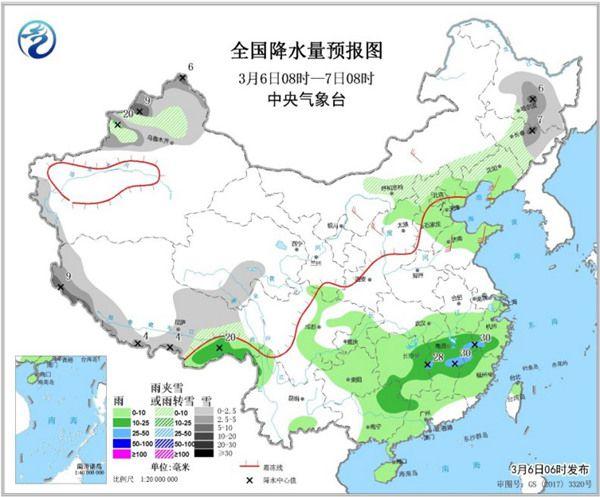
Today, there are light to moderate snow or sleet, and local heavy snow in parts of northern Xinjiang, central Inner Mongolia, northern Hebei, central east and southeast of Northeast China, western Tibet and southern Tibet, and southern Qinghai. There was light to moderate rain in some parts of southern Liaoning, northern and eastern North China, eastern Huanghuai, western Jianghuai, southern Jiangxi, eastern southwestern China, most of southern China, and southeastern Tibet, and local heavy rain.
At 08:00 on the 7th to 08:00 on the 8th, there were light to moderate snow or sleet, and local heavy snow or blizzard in some areas in northern Xinjiang and the western part of the southern Xinjiang Basin, eastern northeast China, most of Tibet, and southern Qinghai. 12 mm). There were moderate to heavy rain in most areas of the south of the Yangtze River, southeast of Chongqing, and southeastern Tibet, and local heavy rain (50-65 mm).
In addition, with the increase of warm and humid airflow, the relative humidity will increase. From the night of the 6th to the morning of the 7th, foggy weather will occur in parts of the eastern part of Jianghan and western Jianghuai and other places. During the night of the 7th to the morning of the 8th, foggy weather will occur in parts of eastern North China, eastern Huanghuai, eastern Jianghuai and other places. The public should pay attention to the adverse impact of low visibility weather on traffic.
After this round of precipitation, a new round of processes will seamlessly connect. On the 8th and 9th, a large-scale rain and snow process will occur in the central and eastern regions. Sleet, moderate to heavy rain in Jianghan and Jiangnan.
North and South temperatures rise 7-9 days with cold air to suppress
Today and tomorrow, most of our country will be dominated by warming. The areas with the highest temperature of 15 ℃ and above 20 ℃ will expand. Tomorrow, the maximum temperature 15 ° C line will advance north to the middle of North China. The maximum temperature in the Beijing-Tianjin-Hebei area can reach about 15 ° C. In the northwest region, Huanghuai to Jiangnan, the maximum temperature in many places is expected to approach or even reach 20 ° C . In cities like Nanjing and Hangzhou, tomorrow's maximum temperature will rise to about 18 ° C, and the feeling of humidity and cold will be significantly eased. Northeast China rose to a high point the day after tomorrow, and the highest temperature generally rose above 5 ° C.
The temperature rise from the southwest to the south China is even more vigorous, and the cumulative increase will exceed 10 ° C. It will rise to a high point around next Monday, and the range above 30 ° C in Guizhou, Yunnan, Guangxi, and Hainan will increase significantly. Among cities, the maximum temperature on Sunday in Nanning and Haikou may reach above 30 ° C.
However, the temperature fluctuations are still relatively frequent at this time. A round of cold air gradually affected our country from west to east and from north to south on the 7th-9th, the temperature generally fell by 6-10 ° C, and the local temperature dropped by more than 12 ° C.
On the 7th, cold air took the lead to affect Xinjiang. On the 8th and 9th, the rapid eastward movement to the south affected the central and eastern regions. Especially in the eastern part of the northwestern region, the highest temperature on the 7th is still around 15 ℃, which is relatively warm, and it will drop to around 5 ℃ on the 8-9th. The temperature fluctuates greatly. The public should pay attention to the weather forecast and pay attention to the timely addition of clothing.