
China News Service, February 29th. According to the website of the Central Meteorological Station, during the day from February 29th to March 1st, there was light to moderate rain in the eastern and southern parts of the southwestern region, Jianghuai, Jiangnan, and South China. Among them, eastern Guizhou and Hunan Some areas in the south and central Jiangxi have heavy rain and local heavy rain (50-80 mm). Some of the above areas are also accompanied by strong convective weather such as lightning and short-term heavy precipitation.
In addition, under the influence of weak cold air, from February 29 to March 1, northerly winds of magnitude 4 to 6 will appear in northern Xinjiang, eastern northwestern China, Inner Mongolia, northern China, and Huanghuai, and some parts of the above areas will cool by 4 ~ 6 ℃; there will be light to moderate snow or sleet, and local heavy snow in parts of eastern Inner Mongolia, northeast China and northern North China.
During the morning and morning of February 29, heavy fog was found in southern Hebei, central Henan, southeastern Shanxi, northern and central Shaanxi, central Hubei, southwest Chongqing, and parts of the northern Bohai Sea, with strong local visibility less than 200 meters. Dense fog. The foggy weather in the above areas is mainly concentrated in the morning. For this reason, the Central Meteorological Observatory continued to issue a yellow warning of heavy fog at 06:00 on February 29.
National Fog Forecast Map (08:00 on February 29-14:00 on February 29)
Specific forecast for the next three days
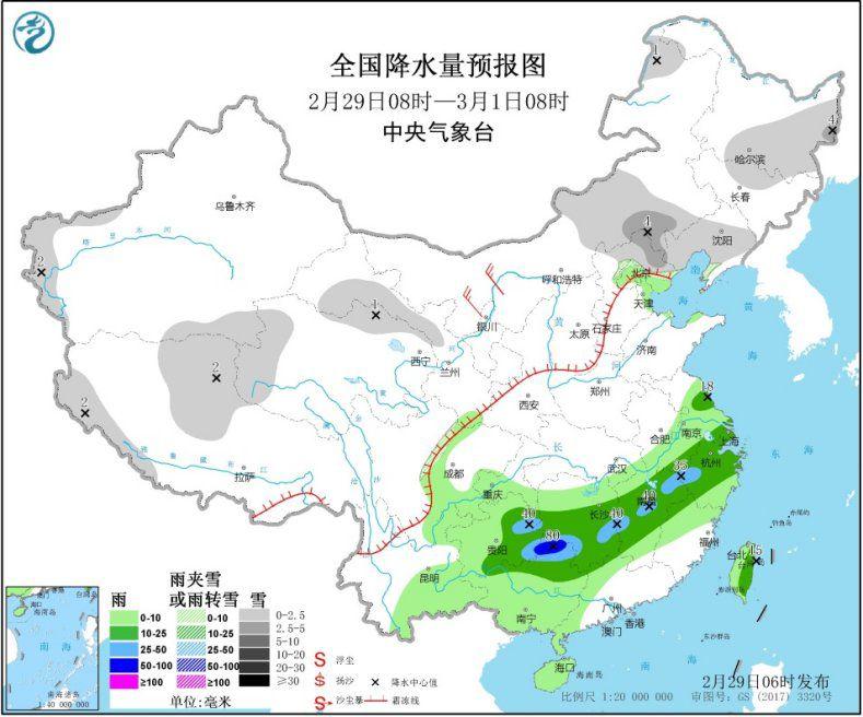
From 08:00 on February 29th to 08:00 on March 1st, there were small to moderate snow or sleet in parts of southwestern Xinjiang, western Tibet, western Gansu, eastern Inner Mongolia, northern North China, most of Liaoning and central and eastern Heilongjiang Snow; light to moderate rain in eastern southwestern regions, most of southern Jiangnan, northern southern China, and Taiwan Island. Among them, eastern Guizhou, southern Hunan, and central Jiangxi have heavy rain and local heavy rain (50-80 mm). . In parts of northern and eastern Xinjiang and western Inner Mongolia, there were 4 to 6 winds.
National precipitation forecast map (08:00 on February 29-08:00 on March 1)
From 08:00 on March 1 to 08:00 on March 2, there were light to moderate snow or sleet in parts of most parts of Tibet, eastern and southern Qinghai, western Gansu, northern North China, and eastern Northeast China. Light to moderate rain occurred in the southwestern region, western Jiangnan, southern China, and Taiwan Island. There are 4-6 winds in the central and eastern parts of Inner Mongolia.
National Precipitation Forecast Map (08:00 on March 1-08:00 on March 2)
From 08:00 on March 2 to 08:00 on March 3, there were small to moderate snow in central Tibet, most parts of Qinghai, eastern Inner Mongolia, northern North China, southern and eastern Northeast China, and parts of Southeast Qinghai and eastern Inner Mongolia Heavy snow (5-8 mm); light to moderate rain in the eastern southwest, Jiangnan, South China and other places, including heavy rain (25-40 mm) in parts of southern Guizhou and northwestern Guangxi. There are 4-6 winds in central Inner Mongolia.
National precipitation forecast map (08:00 on March 2-08:00 on March)