
China News Service, February 23. According to the website of the Central Meteorological Observatory, in the next three days, the middle and eastern part of the Qinghai-Tibet Plateau will be small to medium snow. From 24 to 25, there will be a precipitation process in North China, Huanghuai, Jianghan and other places.
Yesterday snowfall in eastern Tibet and other places
Yesterday, most regions of the country experienced less precipitation. There were light to moderate snow in eastern and southern Heilongjiang, central and eastern Jilin, eastern Tibet, and southern Qinghai, and heavy snow (5 mm) in Nagqu, Tibet.
This morning, heavy fog appeared in parts of southwestern Chongqing, central and western Guizhou, and western Guangxi, and local visibility was less than 200 meters.
Snowfall on the Qinghai-Tibet Plateau and other places
In the next three days, the middle to eastern Qinghai-Tibet Plateau will be small to medium snow. On the 23rd, there was light to moderate snow in the northern part of Xinjiang and heavy snow in some areas. From 24 to 25th, there were light to moderate snow or sleet in parts of eastern Inner Mongolia, northern Hebei, and central and southern Liaoning.
There will be precipitation in Huanghuai River and Han Dynasty
Affected by the low-level shear line, there will be a precipitation process in North China, Huanghuai, Jianghan and other places from 24 to 25, mainly from light to moderate rain, and local heavy rain.
Specific forecast for the next three days
From 08:00 on February 23 to 08:00 on February 24, light to moderate snow or sleet was found in parts of northern Xinjiang, northeastern Inner Mongolia, eastern northeast China, northern Tibet and eastern China, and southern Qinghai. There is heavy snow in some areas. There was light rain in the east and southwest of the southwest, western Guangxi, and the southeast of the northwest, and there was moderate rain in western Yunnan (see Figure 1).
Figure 1 National precipitation forecast map (08: 00-24 February 08:00)
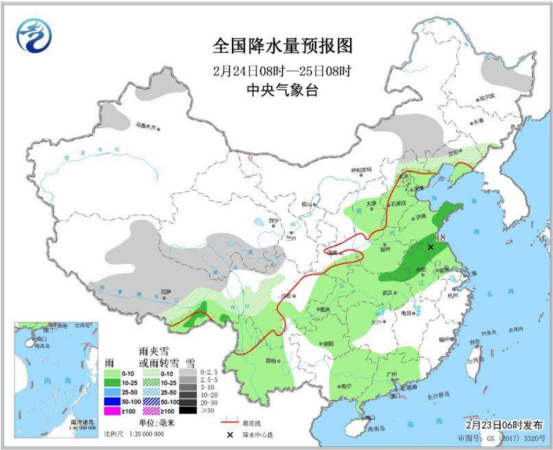
There was light snow or sleet in parts of northern Xinjiang, eastern Inner Mongolia, southern Qinghai, and central and eastern Tibet from 8:00 on February 24th to 8:00 on the 25th. There was light rain in parts of eastern and central and southern China, Huanghuai, most of Jianghan, eastern southwestern China, central and western Yunnan, and most of southern China, and moderate rain in parts of southern Huanghuai. In parts of western Inner Mongolia and other places, there are 4 to 5 winds (see Figure 2).
Figure 2 National Precipitation Forecast Maps (08: 00-25 February 08:00)
From 08:00 on February 25th to 08:00 on 26th, there were light to moderate snow or sleet in some parts of Xinjiang along the Tianshan region, the central and eastern part of the Qinghai-Tibet Plateau, eastern Inner Mongolia, and the southeast of Northeast China. There was light rain in most areas of Jianghan, east of the southwest, Jianghuai, northern and western Jiangnan, and most of southern China. Among them, there were moderate to heavy rain in parts of southern Hubei, southern Anhui, northern Hunan, and northwestern Jiangxi (see image 3).
Figure 3 National Precipitation Forecast Map (February 25th, 08h-26th, 08h)