
- DANA: Fourth mortal victim trapped in a car submerged in Jámula, Granada
- Red alert.The Segura river overflows and floods the entire region of the Vega Baja of Alicante
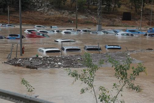
- Alicante.Angustia in Orihuela after the overflow of the Segura: "There is already a meter of water in some points of the center"
- Cold drop.DANA: The destruction of torrential rains in images
The Spanish Levante is currently suffering the consequences of an atmospheric phenomenon that leaves rivers overflowing, reservoirs on the edge of its maximum capacity, flooded towns, roads cut and a balance, for the moment, of four fatalities. It is a DANA , the acronym for Isolated Depression in High Levels and what we commonly know as cold drop. At 5,000 meters high, a mass of cold air, in contrast to the warm Mediterranean temperatures, has generated storms and heavy rains that keep the southeast and southern coast of our country on red alert .
DANAS are common at this time of year. They are usually generated in the Mediterranean area at the beginning of autumn , during the months of September and October. "As such it is a phenomenon that has a certain recurrence and that is not strange to us in the Mediterranean area. It is not seasonally adjusted. It has not happened out of season," Beatriz Hervella , a member of the Department of Meteorological and Climatological Information, told EL MUNDO from the State Meteorological Agency (Aemet).
However, its magnitude may vary according to the atmospheric conditions of the moment and exceed the historical records. The images of its passage are devastating, but we still cannot " say that this is the most intense DANA we have ever had, " Hervella said, since we are still in it and the next data could go around the registry. "There are no statistics to know how it is usual. To take stock of your activity you will have to wait for it to end," he said.
High intensity
According to Aemet, DANA is still in full activity, so the data changes and increases continuously. The most important are precipitation measures. In the last 48 hours , 452.4 liters per square meter (l / m2) have been accumulated in Beniarrés , 425.4 l / m2 in Orihuela (both in Alicante) and 339.2 l / m2 in Ontinyent (Valencia).
"The truth is that this Thursday there have been historical records or records of precipitation, " said Hervella. Specifically, there are two figures that beat a record not seen so far. While 99.3 liters per square meter (l / m2) were accumulated at the Almeria airport yesterday, in 169 they reached 169 l / m2. These amounts refer to the maximum daily rainfall and have exceeded those that occurred in 1968 (historical milestone to the date of Almeria) and in 1984, in the case of Murcia. Hervella has warned that these data could even be refuted tomorrow , but that until this Friday those records already represent an ephemeris.
To get an idea of what such amounts mean we could look at the airport of San Javier (Murcia), where in just two hours (between five and seven in the morning) 144.3 l / m2 have been registered. "If the climatic averages of what happens in this season are analyzed, what usually falls on average in a whole year is 313 l / m2. This means that, approximately, in two hours almost half of what has fallen usually falls in a whole year, "said Hervella.
This is how DANA will evolve
The DANA, now located in the Strait area, has been moving westward as planned. Throughout the night you will find yourself in the peninsular southwest. The area of Valencia and Alicante are kept in red warning by rain, where they could accumulate between 90 liters / m2 or more in an hour at 180 liters / m2 or more in twelve hours. "Friday is a red threshold, but it rains very wet, since the 400 liters that have already fallen are located in these areas. In Valencia, this midnight, we will be very active and very outstanding," said Hervella. In addition, around these red warning areas there are orange and yellow alert zones towards their periphery.
In the following days, from Aemet they believe that the episode will evolve towards the north, losing virulence, reason why the risk will go lowering its threshold in a situation that tends to cover less adversity. " With the DANA movement, rains tend to spread and lose a lot of intensity, " Hervella said. For this reason, after 24 hours, there will no longer be a torrential intensity, although a greater number of areas will be affected with yellow risk.
Wind warnings will tend to descend and only rains and storms will occur. For this reason, it is unlikely to rain in Galicia, Asturias, Cantabria and the Basque Country . In the rest of the Peninsula the most intense and yellow warning showers would affect Castilla La Mancha, the Community of Madrid, high areas of southern Ávila, mountainous areas of northern and eastern Cáceres. In addition, the center of the province of Valencia, the northern part of Murcia, northern Almeria, Mallorca, the coast of Malaga, Cordoba, Seville and Huelva will remain active.
In 48 hours, the DANA will be consumed and can leave intermittent rains at any point of the Peninsula, keeping the yellow warnings due to rain but of lesser extent. This will only affect the Community of Madrid , the Pyrenees of Huesca and Lleida, northeast of Castilla La Mancha and east of Teruel. "What is clear is that the episode will be losing entity, " said Hervella. For the following week, the probability of precipitation is somewhat higher in the northern third, but without anomalies and "with the season's own time in terms of temperature and precipitation, it has concluded.
According to the criteria of The Trust Project
Know more- Science and Health
- science
- Murcia
- Alicante
- Valencia
- Madrid
- Huesca
- Castilla la Mancha
Spain Torrential rains and storms in the Valencian Community, Balearic Islands and Murcia
Health The largest research center hires the head of Human Resources 'finger'
Health Sanitary alert for botulinum toxin in tuna in Dia sunflower oil: the 4 affected are from the same family