
The country is exposed to a cold air mass that raises dusty winds
15 degrees, a sudden drop in temperature until Saturday
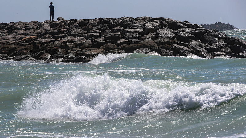
The Meteorological Department warned against going to the sea and engaging in marine activities.
archival
The National Center of Meteorology stated that the country is witnessing a sudden drop in temperatures, ranging from 10 to 15 degrees Celsius, as of tomorrow afternoon, Wednesday, as a result of the effects of a cold air mass accompanied by northwesterly winds that raise dust and dust, which leads to the sea turning into turbulent and extremely turbulent. And that is until the end of next Saturday, after which the temperatures will return to normal levels for this time of year.
In detail, the National Center of Meteorology informed "Emirates Today" that the country will be exposed, as of tomorrow afternoon, to the effects of a cold air mass, resulting from an air depression coming from the north of the Arabian Peninsula, accompanied by northwesterly winds that raise dust and dust, which leads to a decrease of approximately 15 One degree Celsius of the expected temperatures in the Al Dhafra region, while it drops by about 12 degrees Celsius in Abu Dhabi, and from 10 to 12 degrees Celsius in the rest of the emirates of the country.
The center stated that the dust-inducing winds will gradually advance from the western regions of the country towards the interior, with which temperatures will shift from high to relatively low on Wednesday afternoon, provided that winds will permeate most regions of the country as of next Thursday, so that the temperature will decrease by about 12 degrees Celsius, while the sea will change. To turbulent in the Arabian Gulf and the Sea of Oman.
The center expected the effects of the cold air mass to continue until next Sunday, explaining that the effects will begin tomorrow with active and strong winds, which will continue at the same rates until next Friday, while they gradually reduce as of Saturday, so that the weather becomes moderate, provided that the temperature returns to its normal rates at this time of the year. From next Sunday.
The center warned against going to the sea and practicing marine activities during the next three days, in the Arabian Gulf and the Sea of Oman, due to the turbulence of the waves, calling on motorists to take precautions and caution when driving on highways, due to the low range of horizontal visibility, especially in the Al Dhafra region, and some areas in Abu Dhabi.
The center stated that the weather tomorrow will remain clear to partly cloudy at times in some areas, becoming humid at night until Thursday morning, with the possibility of light fog forming over some eastern interior areas, while the winds will become southwesterly light to moderate in speed, turning in the afternoon to northwesterly active. Speed and strong sometimes, especially on the sea to be dusty and laden with dust, which leads to a decrease in the horizontal visibility on some open areas, and its speed ranges from 15 to 25 km / h, and reaches 55 km / h on the sea, which is light to medium waves, It becomes turbulent in the afternoon, and very turbulent at night in the Arabian Gulf, and light to medium waves in the Sea of Oman.
He stated that Thursday's weather will be dusty and partly cloudy in general, with a noticeable decrease in temperatures, while the winds will be northwesterly active to strong speed.
He indicated that the weather next Friday will remain dusty and partly cloudy in general, while the winds will be northwesterly active to strong speed, especially on the sea.
spring season
The National Center of Meteorology confirmed that the spring season will begin geographically next Monday, with the sun perpendicular to the equator, then it will appear northward towards the Tropic of Cancer, pointing out that temperatures begin to rise during this period.
He stated that the country is affected during this month by the passage of surface and upper depressions heading from west to east, and in some cases the depressions deepen in the upper layers of the atmosphere over the region, which leads to the formation of cumulus clouds accompanied by rain and active winds that raise dust and dust, especially over open areas.
Follow our latest local and sports news and the latest political and economic developments via Google news